Scrutiny Grows Over Mandatory vs. Voluntary Evacuation Orders
Mudslides Breached Highway 192 Line and Raced Through Voluntary Zones

Three days after a violent rainstorm dislodged entire hillsides of Montecito’s fire-wracked front country, killing 18 people and triggering searches for five more, all available rescue resources, including more than 1,500 boots on the ground, 10 helicopters in the air, and an army of support personnel, remain entirely and justifiably devoted to search efforts while hope remains more survivors could be found.
Authorities say it’s premature to begin scrutinizing public safety preparations, which were largely thorough and robust, made in part by the County of Santa Barbara and the Sheriff’s Office ahead of Tuesday’s record-breaking storm. “There will be an appropriate time when everything will be assessed, and we will take a look at what happened,” Sheriff Bill Brown said Thursday. “Now is really not the appropriate time to do that.”
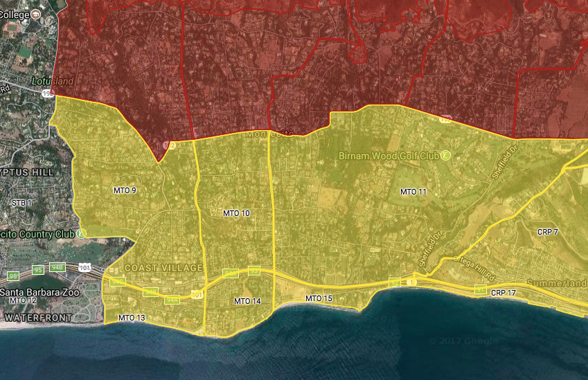
Still, many have been unable to stop themselves from questioning the adequacy of the evacuation orders and warnings issued Sunday afternoon by the Sheriff’s Office. While a large portion of Montecito was placed under a mandatory evacuation order ― neighborhoods populated with 7,000 residents along the northern edge of town, closest to the Thomas Fire burn scar ― the rest of the community was issued a voluntary evacuation warning. Approximately 23,000 people lived in the voluntary area.

In disaster situations, mandatory evacuation orders inform residents of imminent, life-threatening danger. They’re told in no uncertain terms to leave the area straightaway. Voluntary evacuation warnings advise residents to pack their belongings, stay on high alert, and be ready to evacuate at a moment’s notice. Many homes were destroyed and a number of people were killed by debris flows in the voluntary zone. Exact figures are not yet available.
On Friday, January 5, four days before rain clouds came barrelling into the South Coast, county officials held a press conference to warn the public of a major storm event on the way that was expected to deliver biblical volumes of rain and cause flooding in and below the Thomas Fire burn scar between Montecito and Carpinteria. The storm was forecast to hit sometime Monday night or early Tuesday morning.
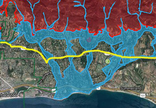
County Public Works Deputy Director Tom Fayram presented a map that highlighted the predicted flood zones, which ran down downhill along Montecito, Oak, San Ysidro, and Romero creeks, reaching all the way to the ocean and pooling between Fernald Point to the east and Butterfly Beach to the west. Fayram explained during the media gathering, which was covered by the Santa Barbara Independent and other area news outlets, that the potential for flash floods in the burn area was 10 times greater than a normal year because the Thomas Fire has burned off the top layer of soil that normally acts as a sponge during rainstorms. “[Flooding] is a significant risk to our community,” said Fayram, adding that crews were wrapping up weeks of work cleaning out 11 debris basins in the area of concern. “And it isn’t just about this storm. It will be about this season and next season.”
On the afternoon of Sunday, January 7, the evacuation advisories were announced, broadcast far and wide by the County’s Office of Emergency Management via media alerts, emails, website notices, and social media posts. Although Fayram’s flood map appeared to predict danger areas that reached all the way from the mountains through Montecito to the ocean, mandatory orders stopped at Highway 192, then turned to voluntary warnings.

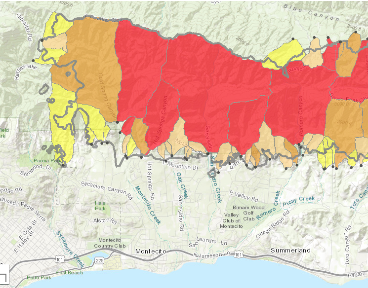
The next day, Monday, January 8, the United States Geological Survey (USGS) published its own map that estimated the likelihood of debris flows throughout the Thomas Fire burn scar area. The USGS predicted there was a 60-80 percent chance of mudslides originating directly above Montecito. Sheriff’s deputies went door-to-door in the mandatory zone that day, imploring people to leave. A mere 15-20 percent complied, the rest either too fatigued by the recent Thomas Fire evacuations to leave again, or too confident in their ability to weather the storm.
The Santa Barbara Sheriff’s Office is the county agency tasked with creating and enforcing evacuation areas. The exact method it uses to draw boundaries, including what information is used, which experts are consulted and when, and so on, was not available for full explanation Friday as the department remains concentrated on search and rescue. Sheriff Bill Brown did say during a press conference Tuesday afternoon that both types of zones were developed based on predictions supplied by meteorologists, Cal Fire and Forest Service personnel, and flood district staff.
“This isn’t an exact science in terms of defining where [a mudslide] is going to happen,” Brown said. “A lot depends on Mother Nature. This was their best guess estimate of where things were going to occur, and as it turns out, they were exactly right.” Brown said it was impossible to predict to “a house or a block or a neighborhood what the impact was going to be.”
An incident command spokesperson said Thursday that Brown would offer more insight on the mapping process during that afternoon’s press conference. He did not, and he was not available for questions after. Fayram declined to comment on why the mandatory zone stopped at Highway 192 while the flooding map predicted stormwater accumulating south of the line. He referred all questions to Brown, as did all the agency officials contacted for comment.
Authorities say it’s impossible to describe what areas of Montecito have been most impacted. The devastation is sweeping. “There’s not one general area,” said County Fire Captain Dave Zaniboni. “It’s spread out. There are no areas worse than others.”

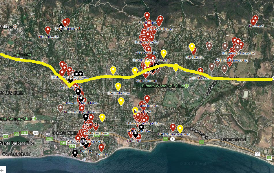
A publicly sourced Google map created by citizens curious and concerned about their individual homes and neighborhoods pinpoints where houses have been damaged and destroyed, as well as where bodies have been recovered. It highlights concentrations of devastation south of Highway 192, especially along Montecito Creek. The map utilizes information gleaned from news reports, eyewitnesses accounts, emergency radio chatter, and social media posts. While the Independent cannot verify the absolute accuracy of the map, much of it has been confirmed by corroborating reporting.
The Independent is also in the process of creating its own comprehensive survey of the damage zone. That map-in-process is published here.


