[Update: Jan. 8, 4 p.m.] Meteorologists with the National Weather Service in Oxnard have updated their rainfall predictions for the current storm. They have forecasted that coastal areas will receive two to four inches of rain, while mountainous areas get four to seven inches. Also, south-facing slopes could receive as much as nine inches.
The county added a voluntary evacuation warning this afternoon for parts of Tepusquet Canyon below this past summer’s Alamo Fire burn zone. The warning area is outlined in yellow on the evac map at countyofsb.org
[Update: Jan. 8, 8 a.m.] El Capitan Canyon was added to the mandatory evacuation order this morning. The Red Cross evacuation center is at the cafeteria at Santa Barbara City College (721 Cliff Dr.). For animals, large ones go to Earl Warren Showgrounds (3400 Calle Real). Small animal can be taken to the Santa Barbara Humane Society (5399 Overpass Rd.).
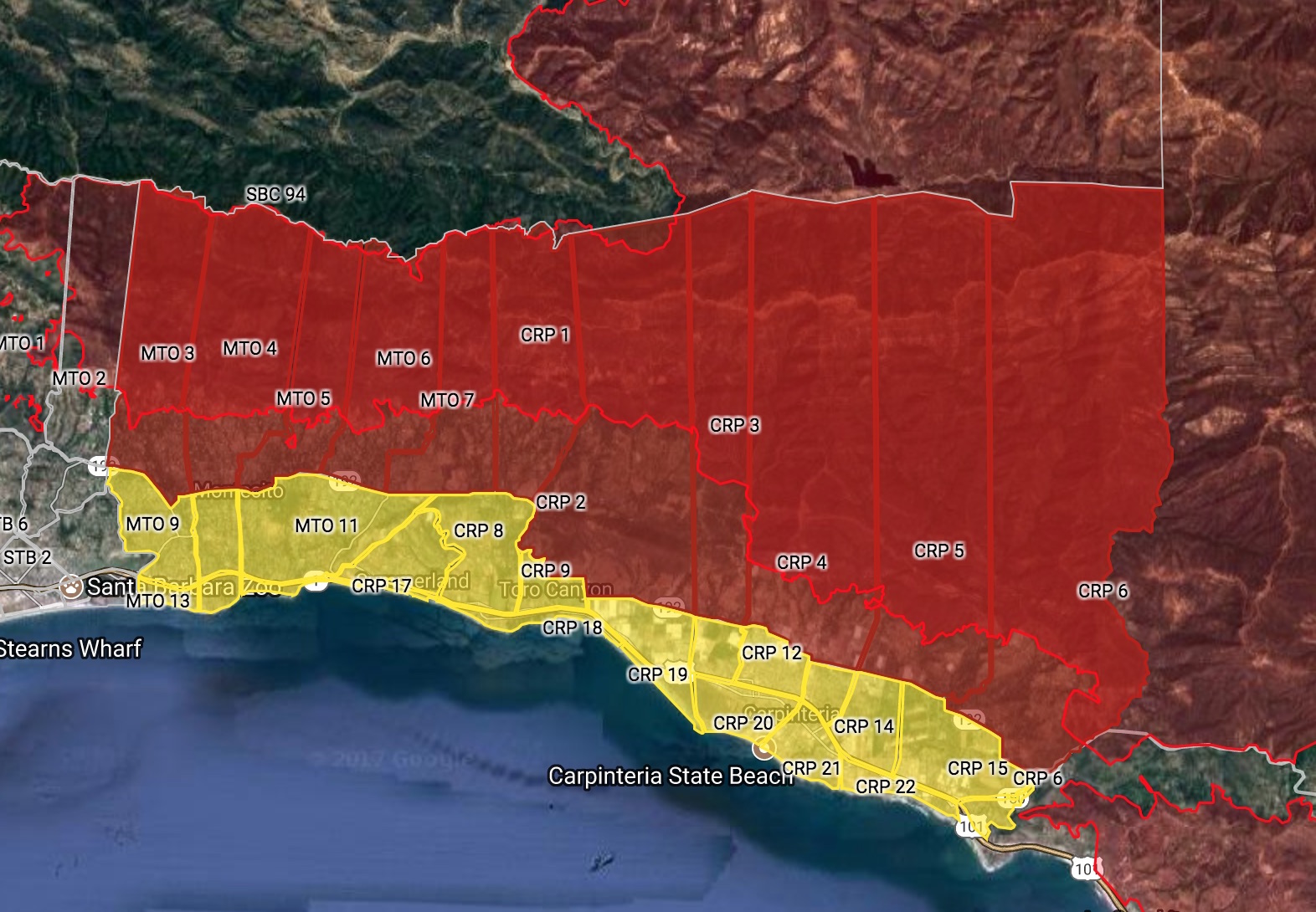
The county will be adding information about the canyons west of Goleta to the interactive map throughout the morning. The map currently is interactive only for highly populated areas under the Thomas Fire. The need for evacuations unfolded rapidly Sunday afternoon, said Rob Lewin, head of the county emergency office, when the federal Burn Area Emergency Response (BAER) team updated its criteria for critical areas. The National Weather Service flood warning was issued Sunday evening.
[Original Story: Jan. 7, 9:34 p.m.] Parts of Santa Barbara County will be back under a mandatory evacuation order as of noon on Monday, again caused by the Thomas Fire, but this time for flash floods and mudflows expected with the coming storm. The approaching heavy rains and high winds are expected to last Monday through Tuesday and create a grave danger of water and debris flows for areas affected not only by Thomas but also Whittier, Sherpa, and Rey fires, the County Executive Office announced Sunday night. The county has cancelled the storm meeting scheduled for Monday evening to keep people off the roads.
Tumbling rock and mud could block roads and delay emergency access should people remain behind, the county stated, emphasizing the need to evacuate before noon on Monday. The mandatory order extends above (north of) Highway 192/Foothill Road, from the county line to Cold Springs Road. This includes areas of Carpinteria, Summerland, and Montecito.
The mandatory evacuation order also includes Whittier Fire areas near Goleta and Tecolote, Eagle, Dos Pueblos, and Gato canyons, according to the county alert.
The county’s interactive flood risk map identifies the evacuation areas and can be found at countyofsb.org. The public information line, 2-1-1, can help those without internet access, and has been under heavy use since the alert went out, said county spokesperson Gina DePinto. People can also call (800) 400-1572.
A voluntary evacuation warning extends south of 192 from the county line to Hot Springs/Olive Mill roads. The county advises staying alert to the storm conditions and being prepared to leave.
To receive the county’s emergency notifications, sign up at awareandprepare.org
An evacuation center will be announced Monday morning. Earl Warren Showgrounds will accept large animals. For small animals, call Animal Services at (805) 681-4332.