
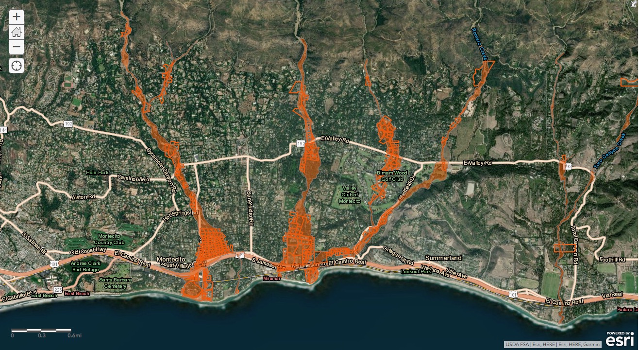
Today, county officials will release an updated map that pinpoints Montecito properties at risk of flooding or debris flows during heavy rainstorms. The new map, called the Interactive Storm Impact Consideration Map and available at ReadySBC.org, dramatically reduces the number of previously identified “red zone” parcels along and below waterways — from 1,472 down to 517. Areas around the Hedgerow, Birnam Wood, and Westmont neighborhoods were all removed.
The reduction is mainly thanks to a healthy 80 percent regrowth of vegetation in the mountains above Montecito that were scorched during the Thomas Fire. Six new ring nets, a lower volume of movable soil and rock, and fully cleared debris basins have also mitigated the threat. “The risk is significantly less from recent years,” said Montecito Fire Chief Kevin Taylor.

Whereas the 1/9 Debris Flow was categorized as a “catastrophic debris flow,” and the one in 1969 following the Coyote Fire was called a “classic debris flow,” there now exists the potential for downgraded but still dangerous “debris-laden flooding” and “clear flooding,” Taylor explained. What Montecito experienced this February, when a strong storm sent rocks rolling into creek channels and water spilling onto Highway 101, falls in the “debris-laden flooding” category. Authorities will remain on the lookout for “high-intensity” storms (those that drop one or more inches of rain per hour) but will also now monitor for “saturation events” (10 or more inches of rain in 3-5 days). Previously, the burnt soil was so water-resistant that saturation wasn’t a concern.
Compared to previous versions, the new map is not an evacuation map, Taylor emphasized, and the 0.8 inches/hour rain threshold that had triggered evacuations earlier this year is no longer in effect. Rather, a combination of factors will determine when authorities tell the community to clear out, including the status of the flood control system and creek choke points, as well as the capacity of basins and nets. “It’s no longer a black-and-white determination,” Taylor said. Future evacuations, he went on, may include just one section of Montecito, all of the red zones, or the entire community, “because we’re still in uncharted territory. … No one has forecasted a potential debris flow from a fire scar three years after an event like 1/9.”

Taylor and a team of scientists, public safety officials, and flood experts will present this information, and much more, at a community meeting starting at 5:30 p.m. on Thursday at Montecito Union School. The meeting will also be streamed live on Channel 20 and on YouTube.


You must be logged in to post a comment.