
Santa Barbara officials are wrapping up the first round of public comment on a new Community Wildfire Protection Plan (CWPP), the playbook by which the city protects itself from the ever-present and, as the climate changes, the ever-growing threat of wildfires. The last plan was created in 2004, and the current effort is being funded by a $310,000 state grant.
While the 2004 plan accomplished a lot ― it set codes and standards for vegetation management, reduced the response times of engine companies, reevaluated the city’s warning system, identified high-risk areas, and so on ― the intervening years inevitably brought up new and different factors to consider.
The updated CWPP, still in draft form, takes into account how, when, and where fires burned over the last decade and a half, and recommends more current methods of fuel reduction. It also incorporates fresh research on “structural ignitability,” or how likely a building is to burn during a fire, which will help homeowners in the wildland-urban interface better protect their properties. The 2004 guidebook did little beyond addressing defensible space.
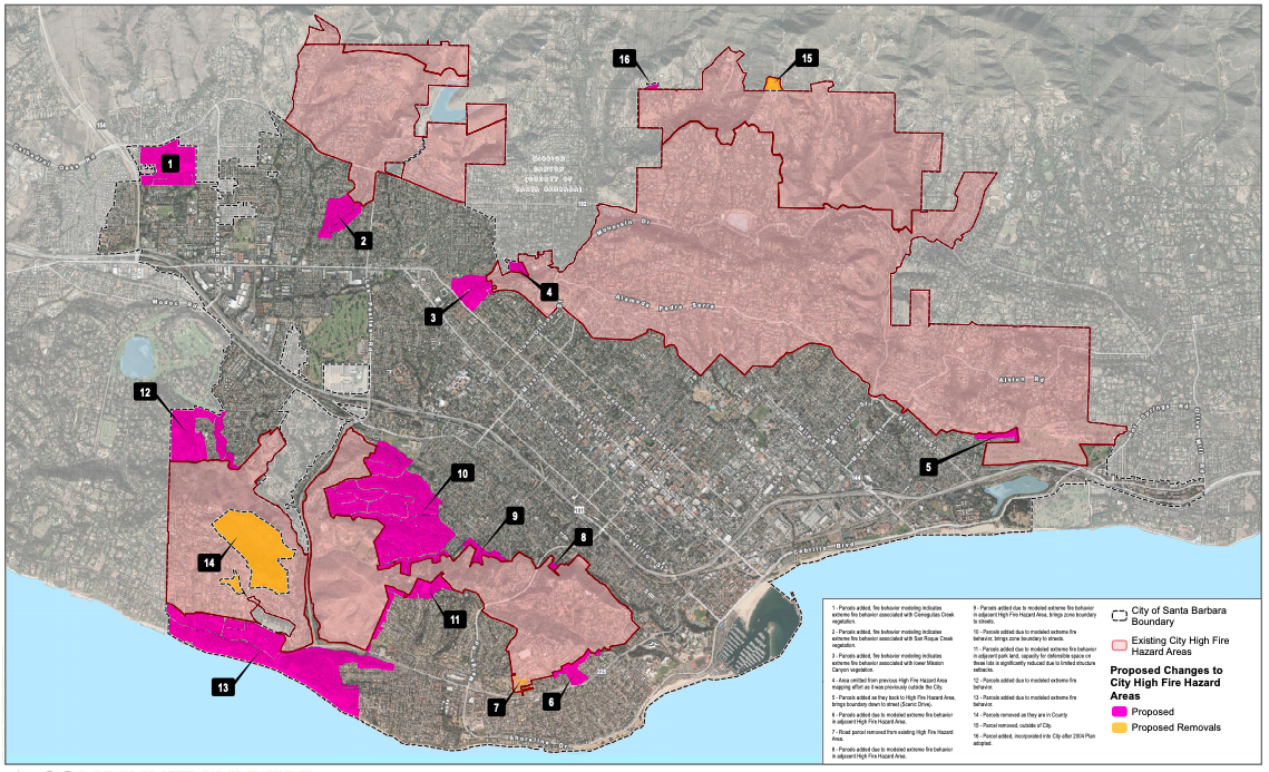
Perhaps most significantly, the draft CWPP recommends expanding what are deemed Santa Barbara’s high fire hazard areas, which could increase insurance rates for residents living in those areas. The proposals are based on modeling that predicts fire behavior by factoring in topography, fuel density, and tree canopy cover during extreme weather conditions, when moisture levels are critically low and sundowners are howling off the mountains at 60 mph.
The potentially expanded areas, highlighted in pink in the map above, include the Bel Air neighborhood below Elings Park, parcels of the Alta Mesa area, a large swath of oceanfront residents west of Hendry’s Beach in Hope Ranch, a section of Mission Canyon that runs down to State Street, parts of San Roque Creek where vegetation has grown, and a chunk of land around the interaction of highways 154 and 192, among a handful of other locations.
The entire CWPP, as well as a helpful FAQ section and recordings of the two public meetings held on the topic, can be found here. The city is accepting public comments until 5 p.m. on Friday, June 5. The deadline was extended in consideration of the coronavirus pandemic. More public input will be taken once the draft plan is completed. That’s expected to happen later this year, with it then going to the Planning Commission and City Council for approval sometime in 2021.
At the Santa Barbara Independent, our staff continues to cover every aspect of the COVID-19 pandemic. Support the important work we do by making a <https://pico.link/sbindependent/">direct contribution.


