
The Heritage Ridge housing project in Goleta hit an unexpected speed bump just hours before its second session at the city’s Planning Commission. Earlier that Monday, the city received a 17-page letter from state Fish & Wildlife regarding four issues on the site: among them a potential “taking” of habitat for a fully protected species — the white-tailed kite — and the need for a wildlife corridor possibly the width of the entire development. On the face of it, both could be deal-killers for a development that includes much-needed affordable housing.
Formerly known as Willow Springs North, the project occupies 17 acres below the corner of Highway 101 and Los Carneros Road. There, Red Tail Multifamily Land Development intends to build 332 apartments, 104 of them to be priced for low and very low-income households, twice the amount required by the city for the development. It’s the third part of the larger Willow Springs project, originally planned in the early 2000s by the late Michael Towbes, who bought the property in the 1980s. Before his death in 2017, Towbes, the founder of Montecito Bank & Trust, was a giant in housing and philanthropy in Santa Barbara County.
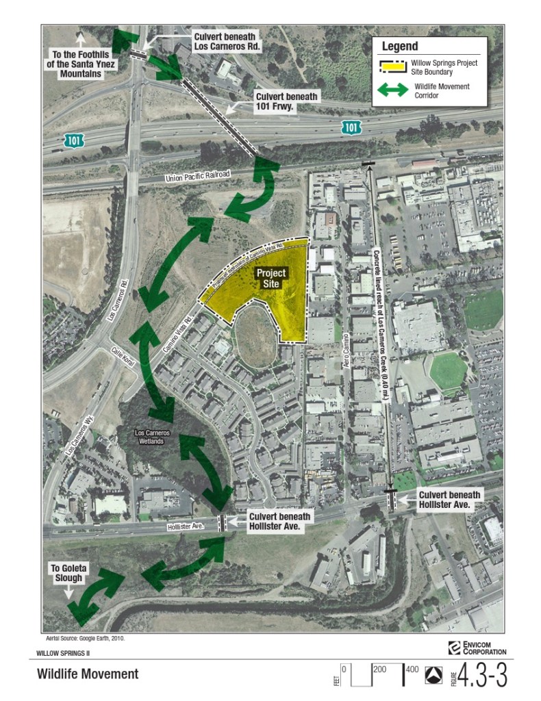
Willow Springs I holds 235 homes, and Willow Springs II has 100. With Heritage Ridge, the three properties fit into the land between Highway 101 and Hollister Avenue. Union Pacific railroad tracks, highway lanes, and Calle Real separate it from Lake Los Carneros to the north. A wildlife corridor is shown to pass through the center of the Heritage Ridge property, then the Los Carneros Wetlands adjacent to Willow Springs I, through a culvert under Hollister Avenue, and into the Goleta Slough around the Santa Barbara Municipal Airport, in the environmental impact report for Willow Springs II.
All of which is to say that the development might have built itself into a corner.
At the project’s earlier meeting in late March before the planning commissioners, the largest disagreement was over six feet of creek setback for Los Carneros Creek and whether the vegetation on the site should be classified as environmentally sensitive. By Monday evening’s meeting, the developer had given up another six feet in the building nearest the creek — about the ninth change the team had made to achieve the creek setback — and the Environmental Defense Center was only calling on the city to note the change in the environmental document.
Sign up for Indy Today to receive fresh news from Independent.com, in your inbox, every morning.
However, the Fish & Wildlife letter points out that the project’s wildlife corridor — 24 to 40 feet wide between a sound wall and South Los Carneros Road — would “result in increased death” among animals known to cross the land, some as large as bobcat and coyote. The alternative was to consider “redesigning the development,” Fish & Wildlife recommended, and possibly increase the corridor to 400 feet, the width of the project property at its narrowest point.
The scientifically accepted minimum width for a wildlife corridor is 1,000 feet “from any human disturbance or uses,” the Fish & Wildlife letter notes. A too-narrow corridor allows interference from road noise and vibration to animals’ detriment in detecting prey and avoiding predators; as well, the development would introduce domestic pets as predators, artificial lighting could disturb nocturnal animals, and the new set of commuters living at Heritage Ridge would be active in the early morning and late evening hours when most wildlife-vehicle collisions occur — all of which contributed to the corridor becoming a “population sink,” or a place where the animal population would decline.
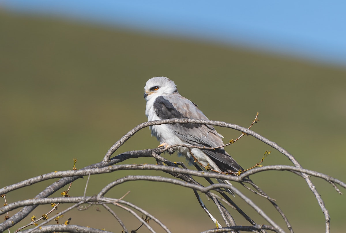
“The [Heritage Ridge] Project site is the only undeveloped site in the immediate area and the only north/south wildlife corridor between the Los Carneros Wetlands and two creeks to the Goleta Slough,” the Fish & Wildlife letter states, a corridor that extends up into the Santa Ynez Mountains. It’s known to be hunting grounds for the white-tailed kite, which nests near Los Carneros Lake to the north and more numerously at More Mesa three miles away. The letter offers possible mitigations for the bird of prey in “setting aside replacement habitat to be protected in perpetuity” as well as an endowment to manage that land.
The two other issues addressed in the letter — locally sensitive vegetation communities and effects on Los Carneros Creek — are also able to be mitigated, the letter states, but studies were necessary, either before the project or after. Regarding all its concerns, which had been expressed previously in a 13-page letter in 2021, Fish & Wildlife disagreed with the environmental report’s findings that they were each “less than significant.”
Asked by Commissioner Katie Maynard what the effect of the Fish & Wildlife letter would be, the city’s environmental consultant, Nicole West of Rincon Consultants, replied that the agency had permit authority over the project concurrent with the city’s on these issues. As the letter was still being digested, those concerns would be their focus in coming days, West said. A date has not yet been set for the third Planning Commission meeting on Heritage Ridge.
Support the Santa Barbara Independent through a long-term or a single contribution.


You must be logged in to post a comment.