
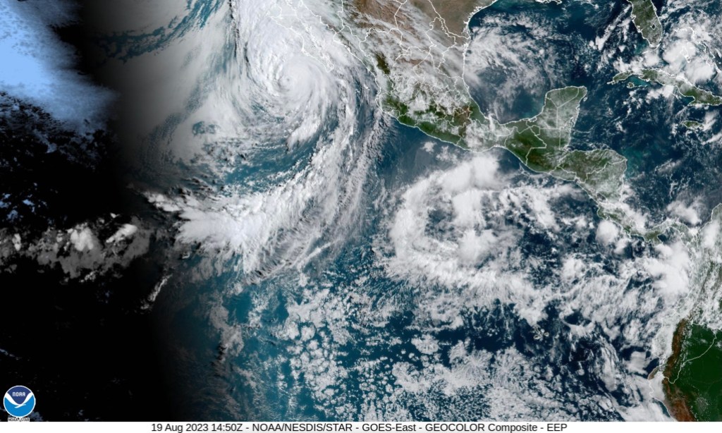
[Update: Aug 20, 2023, 10 a.m.] Just before dawn on Sunday, Hurricane Hilary passed over Isla Cedros onto mainland Baja California, losing its growth potential from the 80 degree Eastern Pacific waters and becoming classified as a tropical storm. Even so, heavy rain and close to 70mph winds are coming from Hilary as the storm heads for Ensenada.
The National Weather Service maps show the storm track following State Route 395 through California’s San Joaquin Valley, up through Bishop, and on to Tonopah, Nevada. Currently moving at about 25mph, Hilary’s effects extend about 240 miles from its center.
The rain and wind will likely find the eastern side of Santa Barbara County, but precipitation is expected to be in the half-inch to inch range Sunday afternoon through early Monday morning. Big ocean swells from Hilary are hitting shore with high surf and rip currents, expected to last through Monday.
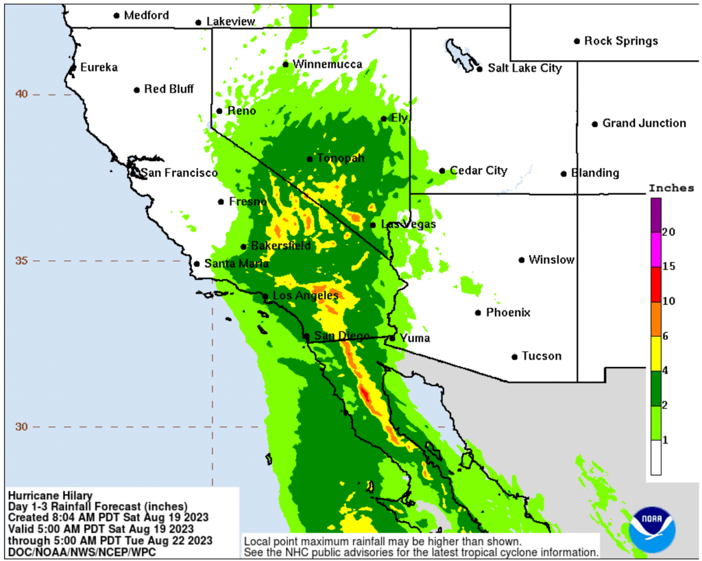
The greatest concern is for the Antelope Valley and the desert communities in Hilary’s path. A storm warning is in place for Los Angeles and Ventura counties for the flooding expected from as much as 10 inches as the very large storm system passes through.
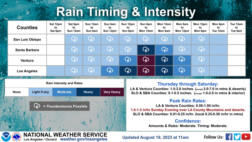
[Update: Aug. 19, 2023, 4 p.m.] The National Weather Service produced this rainfall chart that shows the heaviest rain falling on Sunday 6 p.m. to midnight for Santa Barbara County.
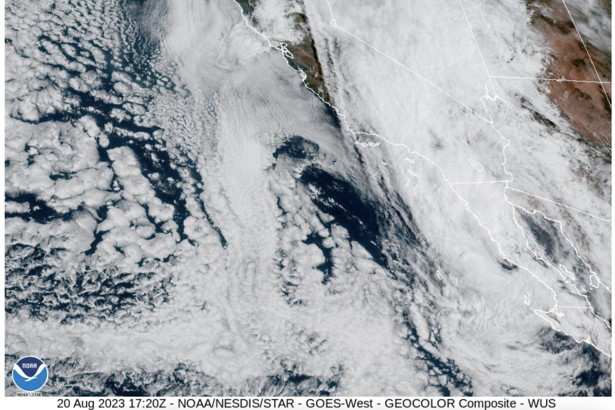
[Original Story] Santa Barbara continues to flirt with tropical weather as the Category 4 hurricane assaulting Baja California sends high humidity, streaks of clouds, and hot temperatures across the county. Areas of Baja are expected to experience heavy rain and mudslides as Hurricane Hilary heads northward. As of Saturday morning, the eye of the storm was several hundred miles west of Cabo San Lucas. For Santa Barbara County, showers may start as early as Saturday night with the heaviest rainfall Sunday night into Monday morning.
The most recent National Weather Service forecast sees the hurricane turning “to the right,” speeding its passage as it moves into colder waters and into drier air over land, and reducing in intensity. The eye of Tropical Storm Hilary currently looks like it will be near San Diego on Sunday evening and head east of Los Angeles on Sunday night, with the storm track ultimately bringing rain to Nevada.
Air Force Hurricane Hunters captured 130 mph winds in the northern portion of Hilary on Friday — which places it as a Category 4 storm. Category 3 starts at over 110 mph, and a tropical storm is between 39 to 73 mph.
Whirling ahead of the center of the storm will be widespread miles of rain and winds gusting to 60mph in mountain areas. As of Saturday morning, Los Angeles and parts of Ventura counties are under a Tropical Storm Warning. Flooding is expected to occur from the 2-4 inches of rain predicted for coastal areas. The San Gabriel Mountains could get as much as seven inches. The approaching cloud cover will also knock about 2-4 degrees off the temperature on Saturday.
“Then it will be game on,” the National Weather Service states. The greatest wind and rain will be south of Santa Barbara, though the eastern Santa Ynez Range could see 3 inches of rain starting Sunday night into Monday morning. A flood watch in Los Angeles, Ventura, and the eastern Santa Ynez Mountains runs from 4 p.m. on Sunday through 11 p.m. on Monday. Lingering thunderstorms and cooler temperatures will be what’s left of the storm after day breaks on Monday.
A tropical storm hasn’t made landfall in California since 1939 when Long Beach flooded under El Cordonazo de San Francisco, according to the Victorville Daily Press, and 93 people drowned. Hilary will bring with her strong winds and even stronger gusts — more than 30 mph in Santa Barbara County — that will come from the northeast, like a wet Santa Ana wind, as the storm is spinning in a counterclockwise direction. Downed trees and power lines are likely.
In anticipation of the wind and rain, Vandenberg Space Force Base moved a launch scheduled for yesterday to next Monday, according to area media reports.
On Friday, the City of Goleta decided to hold its annual Dam Dinner set for Saturday, saying the National Weather Service was “calling for a nice day tomorrow.” The bring-your-own picnic and cutlery fest — to minimize trash — takes place atop the Lake Los Carneros dam, along with a catering truck and music by the Salt Martians from 4-7 p.m.
At the Santa Barbara Harbor, boats parked in the anchorage have been invited into visitor slips for the duration, said Jeanette Prusinski, who took over harbor operations when Erik Engebretson retired last Friday. “Also, vessels that happen to be transiting through are tucking into slips here in order to wait out the weather before continuing onto their destination,” Prusinski said.
Visitors to Los Padres National Forest are warned to postpone their picnic, camp out, or hike until after the storm passes for the flood potential. As much as 6 inches is expected in Los Angeles and Ventura mountain regions and lesser amounts in Santa Barbara. In a heavy downpour, the runoff downstream can quickly form a flash flood.
If the anticipated storm track is off by as little as 20 miles, forecasts will change. To remain updated, several sources to consult are Santa Barbara County’s readysbc.org August 2023 storms webpage, which contains information about sandbag stations and emergency housing; the National Weather Service’s Hilary page; and the National Hurricane Center for the eastern Pacific. Register at ReadySBC.org to receive emergency alerts.


You must be logged in to post a comment.