
[Updated: Sun., Feb. 4, 2024, 3pm]
Santa Barbara County is being hit with persistent rain and wind early Sunday, as a “very strong storm system” made its approach on Saturday night, triggering a flash flood warning and evacuation orders for several parts of South County and bringing what the National Weather Service (NWS) calls “one of the most dramatic weather days in recent memory.”
And while the storm has shifted — with the biggest change being that the heaviest rain has moved eastward over the Los Angeles area — the National Weather Service still predicts “a high risk of dangerous flooding” for southern Santa Barbara County, where evacuation orders remain in effect for properties along waterways in the Thomas, Cave, and Alisal burn scar areas; properties near Sycamore Creek, from Stanwood Drive down to parts of Niños Drive, in the City of Santa Barbara; and all state campgrounds, including Gaviota, Refugio, El Capitan, and Carpinteria. (Residents are encouraged to register for emergency updates on ReadySBC.org, and can use the county’s interactive incident map to check whether they are in an evacuation zone.)
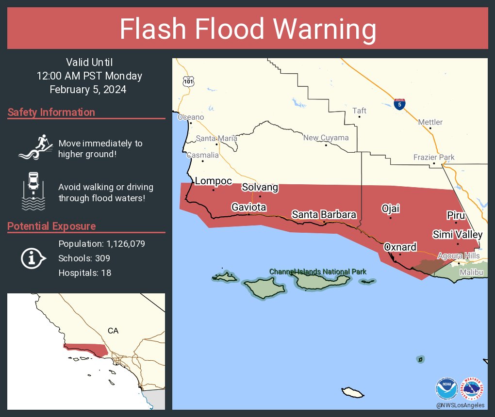
At 2:40 p.m., the NWS issued a flash flood warning for southern Santa Barbara County effective until midnight, stating that flash flooding and debris flows are occurring and will worsen tonight. The warning covers areas ranging from Rincon Point in Carpinteria northwest to Lompoc and Point Conception, where 1-3 inches of rain have fallen and an additional 1-4 inches are possible through the night. Anticipated impacts include “flash flooding of small creaks and streams, urban areas, highways, streets and underpasses as well as other poor drainage and low-lying areas,” the NWS warns, with the potential for “debris flows consisting of rock and mud slides.” A flash flood warning for the Santa Maria, Orcutt, and Arroyo Grande areas also remains in effect until midnight, according to the NWS.

The county has already seen the effects of the rains within the first few hours of Sunday morning. In the past 12 hours, sensors at Point Conception have registered the highest amount of rainfall in Santa Barbara County, with nearly an inch and a half, while most of the sensors within the city limits are registering between a quarter-inch and half-inch from midnight to noon on Sunday.
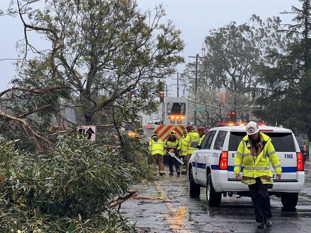
Several incidents have been reported early Sunday morning due to the strong winds, with Santa Barbara County Fire responding to two incidents of downed trees in Goleta and Highway 166 being closed due to a downed power pole near New Cuyama.
County Fire Captain Scott Safechuck reported that a 70-foot-tall tree fell on two units at a condo complex near Ellwood in Goleta shortly after 4 a.m., crashing through the roof and forcing the four residents (and one dog) of both the upstairs and downstairs units to be displaced after both were red-tagged by county officials.
Just a few hours later around 7 a.m., a power pole fell along Highway 166 five miles east of New Cuyama, forcing a closure of the highway while California Highway Patrol and Caltrans responded to the scene.
Then around 11 a.m. another large tree fell across Storke Road in Goleta near Fire Station 11, forcing a closure of Storke Road along both directions at Santa Felicia and Phelps roads while the City of Goleta worked on clearing the area.
Santa Barbara Police were also reporting fallen trees around Santa Barbara, including a tree that took down a power line on Nopal Street before landing on a residential building across the street Sunday afternoon. In a social media post showing the damage from the fallen tree, police asked that residents stay away from downed power lines and report them to 9-1-1. Shortly after that post, at around 2:30 p.m., police announced over social media that Loma Alta Drive between Cliff Drive and Shoreline Drive is closed to all vehicles and pedestrians due to a downed tree on the Santa Barbara City College campus.
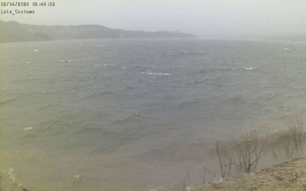
At Lake Cachuma, all four floodgates have been opened as of 10 a.m., with the reservoir’s capacity reported at 89 percent on Sunday morning — down from a high of 93 percent on Friday — and heavier rains expected throughout the rest of the day.
The storm has also forced many local businesses and public transportation to adjust their hours of operation. Santa Barbara MTD announced that on Monday, February 5, it would be operating on “Sunday schedule,” while the county also announced that all Coastal Express bus routes between Ventura and Santa Barbara are canceled for Sunday and likely Monday, and Clean Air Express routes between North and South County have been canceled for Monday.
While no major flood or landslides have been reported yet, county officials are on full alert, and the Weather Service reiterated that this is a “dangerous system with major risks to life and property.”
According to the NWS Sunday forecast: “Many roads and freeways will flood or shut down. Canyon roads will experience significant rockslides. Low-lying neighborhoods will see waters over curbs with a foot or two of water into vulnerable homes and businesses. Many parked cars will be damaged. Mudslides will occur over vulnerable areas. Recent burn scars will experience deep debris flows. Several creeks and the Ventura River will overflow their banks. Strong flows in all creeks and rivers will pose a risk for drowning for anyone in the channels, including the unhoused and anyone camping. Many trees will fall, including in urban areas. Power outages could occur anywhere.”
At La Conchita, an advisory was issued for all residents due to the recent saturation — the area has seen more than four inches of rain and is expected to see another three to five inches in the next five days — with Ventura county officials warning that the upcoming rains “will likely cause the soil to become saturated and result in landslides or debris flows.” The town experienced major landslides following heavy rain in 1995 and 2005, with 10 people confirmed killed in the most recent landslide.
Northern Santa Barbara County is expected to see two to four inches of rain, while the mountains and foothills of Southern Santa Barbara County are projected to see anywhere from four to eight inches, with wind gusts more than 50 miles per hour.
Anybody needing assistance can call the County Call Center at (833) 688-5551. Those seeking shelter can go to the evacuation center at the SBCC Wake Campus on 300 North Turnpike Road. For more information, visit readysbc.org.
Related Posts


Premier Events

Sun, Jun 07
All day
Santa Barbara
SEIMANDI & LEPRIEUR – Hunt Slonem Exhibition Now – June 7
Sat, May 30
12:00 PM
Los Olivos
90’s Unplugged at Firestone Winery

Sun, May 31
1:00 PM
Santa Barbara
Courtyard by Marriott Santa Barbara Presents Sunday Soundwaves

Sun, May 31
6:00 PM
Santa Barbara, CA
Blue Full Moon Ceremony

Sun, May 31
7:30 PM
Santa Barbara
Herman Matthews Presents: Phatback, Earl & Me! SOhO

Tue, Jun 02
5:00 PM
Santa Barbara
UCSB Media Arts & Technology End of Year Show (EoYS): “re:agency”

Tue, Jun 02
7:30 PM
Santa Barbra
Adelfos Ensemble presents: Enlightened Harmonies

Wed, Jun 03
11:40 AM
Santa Barbara
Women’s Prosperity Partners S.B. LEADS Club Virtual Meeting- Female Entrepreneurs

Wed, Jun 03
6:00 PM
Santa Barbara
Chaucer’s Book Talk – Greg Orfalea

Wed, Jun 03
6:00 PM
Santa Barbara
Bingo for Bottles at Carr Winery

Wed, Jun 03
7:30 PM
Santa Barbara
Ensemble Theatre Company Presents “Every Brilliant Thing”
Sun, Jun 07 All day
Santa Barbara
SEIMANDI & LEPRIEUR – Hunt Slonem Exhibition Now – June 7
Sat, May 30 12:00 PM
Los Olivos
90’s Unplugged at Firestone Winery
Sun, May 31 1:00 PM
Santa Barbara
Courtyard by Marriott Santa Barbara Presents Sunday Soundwaves
Sun, May 31 6:00 PM
Santa Barbara, CA
Blue Full Moon Ceremony
Sun, May 31 7:30 PM
Santa Barbara
Herman Matthews Presents: Phatback, Earl & Me! SOhO
Tue, Jun 02 5:00 PM
Santa Barbara
UCSB Media Arts & Technology End of Year Show (EoYS): “re:agency”
Tue, Jun 02 7:30 PM
Santa Barbra
Adelfos Ensemble presents: Enlightened Harmonies
Wed, Jun 03 11:40 AM
Santa Barbara
Women’s Prosperity Partners S.B. LEADS Club Virtual Meeting- Female Entrepreneurs
Wed, Jun 03 6:00 PM
Santa Barbara
Chaucer’s Book Talk – Greg Orfalea
Wed, Jun 03 6:00 PM
Santa Barbara
Bingo for Bottles at Carr Winery
Wed, Jun 03 7:30 PM
Santa Barbara

You must be logged in to post a comment.