
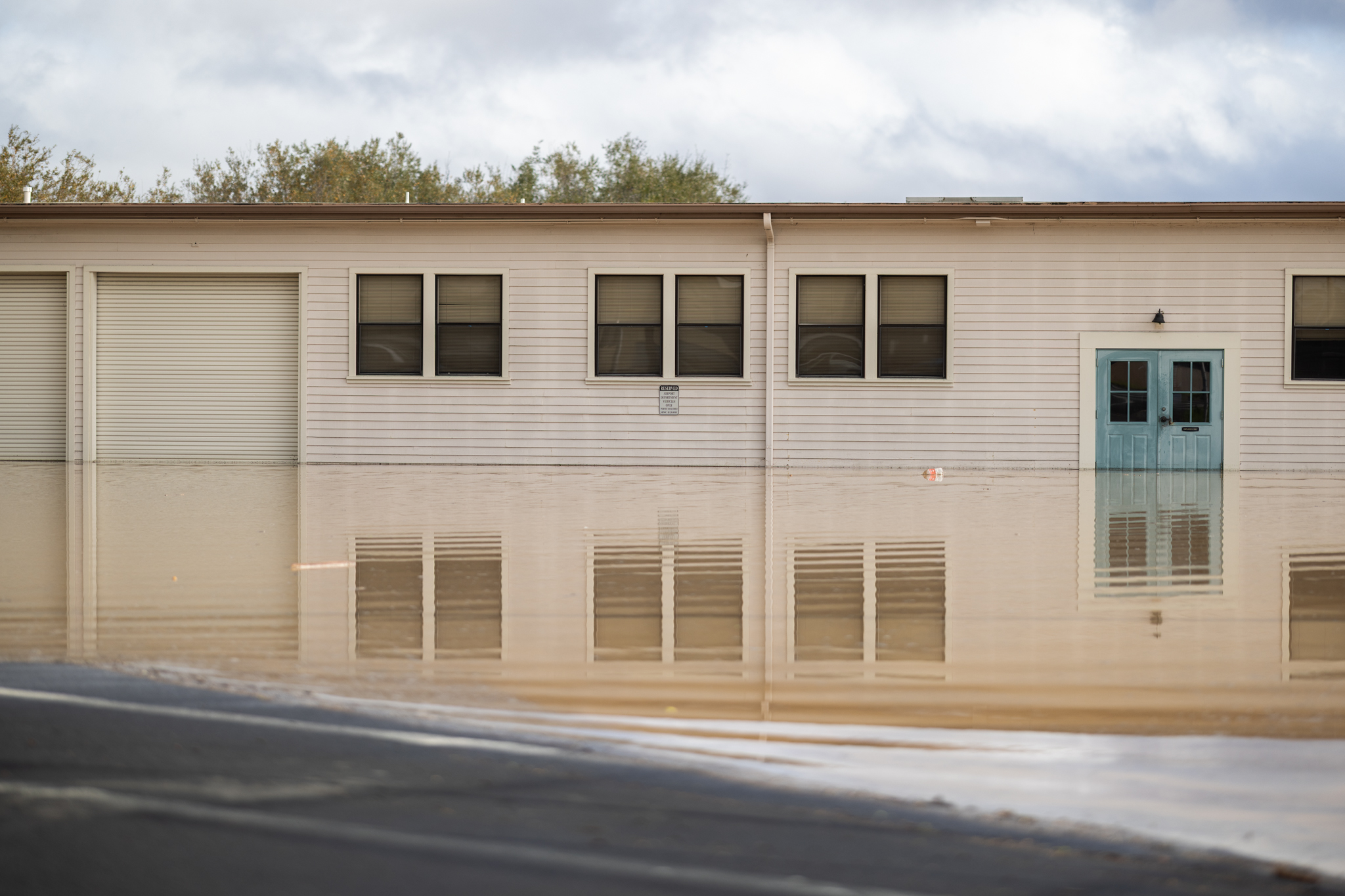
During the heavy rains this December and January, the Santa Barbara Airport’s (SBA) tarmac turned into a lake.
Flooding closed the airport three times, canceling daily flights and stranding passengers. As these airport-shuttering levels of rainfall only increase in frequency, officials are trying to get ahead of the problem before runways are permanently submerged.
When intense storms hit, nearby creeks and wetlands overflow. With nowhere else to go, the water spills into the airport. Once it starts, trying to control it is hopeless.
On December 24, 2025, Airport Director Christopher Hastert saw this for himself. Even after the rains had stopped, the water just kept coming “for hours and hours,” he said.
The airport started the process of addressing future flooding in 2023, thinking that sea-level rise would be their main opponent. The main terminal’s highest point is only 14 feet above sea level — “so we’re flat,” noted Airport Planner Jessica Metzger.
But it soon became clear that their most immediate concern was not rising out of the sea, but falling out of the sky. More rainfall due to climate change means more common and severe flood events that Santa Barbara and its older facilities were not built to handle. Compounded by sea-level rise, higher risk of flooding puts airport infrastructure, facilities, and operations at risk.
Short of relocating the entire 950-acre airport — which is a real possibility — a plan is being developed to weather rising sea levels and worsening storms.

Bathtub Overflowing
The airport sits right next to the Goleta Slough, a large salt marsh. When it rains, watersheds from the Santa Ynez Mountains act as a faucet, emptying into the slough as if it were a bathtub. When it gets too full, it overflows, leaking into the airport.
Airport staff use pumps to remove water from the runways, but recent rains were too much. The airport must close and ground flights when water reaches runways to prevent planes from hydroplaning.
“Not just the rain is falling on the airport, but all of that sediment and sand comes down from those mountains above us,” Metzger said. “It covers our runways and our taxiways. So we’re mucking out debris long past the rain … it takes longer than the general public thinks.”
That’s exactly what happened this past December and January. It was one storm after another. January flooding affected multiple buildings, and resident companies like Easy Lift were temporarily displaced from their offices. Full cleanup will take months — racking up about $2 million in emergency repair work and counting. Closures also canceled about half of the airport’s 23 daily flights.
“Rainfall events that we’ve gotten over the past five years are stronger and harder,” said Metzger, an experienced planner who’s been with the airport for three years. “More than we have been used to in the past.”
“These holiday storms were not unique to Santa Barbara by any means,” she added. “Harbors and piers and other airports up and down the coast were having the same issues we have.”
But that’s just a peek of what is to come.
Flooding Past and Future

Flooding during major storms dates back to when the airport first opened in 1936. It was built in a coastal wetland at the convergence of five major streams. It’s flooded about 16 times since opening, including twice in 2024, twice in 2025, and once already in 2026.
But inundated runways are becoming more common. Severe storms that cause airport closures — about 7.5 inches of rain — used to happen once every 20 years on average. But in the future, it is expected to be as common as every five years. This increase in rainfall will double or even triple the chance of flooding, according to official estimates.
Sea-level rise, which has already begun along the California coast and could, in a worst case scenario, reach up to 6.6 inches, will only exacerbate the issue.
Annual flooding-related costs will increase until the airport is flat-out inoperable, which could occur with between 2.5 and 3.3 feet of sea level rise (2068 to 2108), according to city documents. Total losses from storms, depending on severity, could reach up to $158 million through 2076. When the airport shuts down, it loses about $120,000 in revenue per day.
Passengers are expected to bear 71 percent of the losses, primarily from delays and cancellations.
Thus the need for a plan to adapt. The airport’s Climate Adaptation Plan (CAP) is meant to identify ways to prevent flooding and keep the airport open in the face of rising sea levels and intensifying storms, “balancing nature-based solutions and infrastructure improvements.”

Phase one involved a vulnerability assessment to inform phase two, which is identifying flood-reduction strategies and habitat restoration for the Goleta Slough. Continual flooding, Metzger noted, would gradually change the habitat of the endangered species that call the Goleta Slough home.
Phase one listed everything they needed to protect, and phase two is “How do we protect it?” she said.
“We’re keeping in mind not just the airport being open, but also being good land stewards of this very unique habitat that we have on city property,” she added.
The CAP builds on past plans — including the city’s Sea Level Rise Adaptation Plan (2021) and the Goleta Slough Area Sea Level Rise and Management Plan (2015) — as well as several ongoing and planned flood adaptation measures.
“We have been looking at fixing this problem before it became an immediate problem last month, and we’re still going forward with the permanent permits for that,” Metzger said.
In simple terms, they are considering wetland and creek restoration so these channels can capture and divert water away from the airport, as well as flood-proofing infrastructure upgrades.
Ongoing measures include sediment management in nearby creeks to increase flood capacity. They are also maintaining a temporary flood barrier (or K-rail) along Carneros Creek and another inflatable tube barrier (tiger dam) along the Firestone Channel. But while these dams are good at keeping debris at bay, they are not always successful when it comes to water, Metzger said.


Taxiway flooding and a flooded aircraft tie-down area at Santa Barbara Airport in 2023. | Credit: Courtesy
Planned improvements in the near-term include dredging Carneros Creek and storm drain improvements outlined in the airport’s Drainage Master Plan from 2024 — which could include storm drainage systems, drainage structures, erosion control measures, and detention basins.
Immediate strategies detail replacing the temporary K-rail with a permanent flood berm, potentially expanding the Carneros Creek and restoring floodplain habitat, and constructing a stormwater detention facility. Later strategies could include tidal habitat restoration and flood storage improvements, dredging the Goleta Slough, and utility upgrades.
Long-term planning revolves around the costs and impacts of protecting the airport in place, a regional flood control system, and elevating airport infrastructure. It also considers the possibility of relocating the airport, which would be a complicated last resort.

Next Steps
The beginning of 2026 has seen two public meetings on the airport’s Climate Adaptation Plan to protect the airport from future flight-grounding deluges, which was met with support from the Airport Commission and Sustainability Committee.
Next steps include completing phase two. The city is planning to estimate costs of immediate adaptation measures and implementing the Drainage Master Plan. They want to figure out the quickest solution to keep the airport open, while making sure it doesn’t make the problem worse elsewhere.
“That is our main purpose, is making sure the airport stays open. We don’t want to detrimentally affect our community by having a closed major Regional Transportation Center here,” Hastert said.
They are also collaborating with the Goleta Creeks Department and their neighbors, such as UC Santa Barbara, to restore creeks and improve flood management.
“We all have sea-level rise, we all have these creeks, so we’re working collaboratively,” Metzger said. “We’re not an island airport.”
They plan to prepare a draft CAP by April, which will be released to the public by July. Phase three will involve SBA updating its Coastal Land Use Plan to incorporate adaptation policies, aligning with the latest state and local guidance on sea-level rise and resource protection.
The CAP is funded through the Airport Budget ($255,000) and two separate grants from the California Coastal Commission ($245,000 and $243,000).
Related Posts


Premier Events

Mon, Mar 09
6:00 PM
Santa Barbara
ART 4 GRIEF Support Group

Sat, Mar 14
7:00 PM
Santa Barbara
Red, White, & Blues II: The American Songbook
Sun, Mar 15
3:00 PM
Santa Barbara
Red, White, & Blues II: The American Songbook

Thu, Mar 12
6:00 PM
Santa Barbara
Poetry, Typewriters, and Collage Workshop

Thu, Mar 12
6:30 PM
Santa Barbara
An Evening of Wild Hope: PBS Film Screenings

Thu, Mar 12
7:00 PM
Santa Barbara
Lights Up! Presents: “The Addams Family”

Thu, Mar 12
7:30 PM
Santa Barbara
UCSB Music of India Winter Concert

Fri, Mar 13
6:00 PM
Santa Barbara
GLOW X: A High-Definition Neon Experience

Fri, Mar 13
7:00 PM
Goleta
Folk Orchestra of Santa Barbara Celtic Concert

Fri, Mar 13
7:00 PM
Goleta
Peace Event

Sat, Mar 14
1:00 PM
Santa Barbara
St. Patrick’s Day Irish Firedance

Sat, Mar 14
1:00 PM
SANTA BARBARA
SBCC’s Science Discovery Day

Sat, Mar 14
3:00 PM
435 State St, Santa Barbara, CA 93101
☘️ Santa Barbara St Patrick’s Day Bar Crawl & Block Party
Mon, Mar 09 6:00 PM
Santa Barbara
ART 4 GRIEF Support Group
Sat, Mar 14 7:00 PM
Santa Barbara
Red, White, & Blues II: The American Songbook
Sun, Mar 15 3:00 PM
Santa Barbara
Red, White, & Blues II: The American Songbook
Thu, Mar 12 6:00 PM
Santa Barbara
Poetry, Typewriters, and Collage Workshop
Thu, Mar 12 6:30 PM
Santa Barbara
An Evening of Wild Hope: PBS Film Screenings
Thu, Mar 12 7:00 PM
Santa Barbara
Lights Up! Presents: “The Addams Family”
Thu, Mar 12 7:30 PM
Santa Barbara
UCSB Music of India Winter Concert
Fri, Mar 13 6:00 PM
Santa Barbara
GLOW X: A High-Definition Neon Experience
Fri, Mar 13 7:00 PM
Goleta
Folk Orchestra of Santa Barbara Celtic Concert
Fri, Mar 13 7:00 PM
Goleta
Peace Event
Sat, Mar 14 1:00 PM
Santa Barbara
St. Patrick’s Day Irish Firedance
Sat, Mar 14 1:00 PM
SANTA BARBARA
SBCC’s Science Discovery Day
Sat, Mar 14 3:00 PM
435 State St, Santa Barbara, CA 93101

You must be logged in to post a comment.