

It’s been less than two months since flames raced through the Santa Barbara backcountry, burning more than 240,000 acres in a fire that took nearly two months and more than $120 million to put out. For a blaze that turned out to be historic in proportions-it was the county’s largest and the state’s second largest, at least in recorded history-it is remarkable how quickly the Zaca Fire has faded from our consciousness. But while the fire’s smoke plumes and emergency alerts may be forgotten, its aftereffects will be with us for years.
It’s hard to get a handle on a fire that chews up 375 square miles of the rugged and remote Los Padres National Forest. Part of this is because so much of the burned area is way out of sight. There wasn’t much you could see when the wildfire was attacking its 100-mile perimeter and there’s even less now, save for a small section close to Highway 33. So despite the terror it repeatedly sparked in foothill residents and the nightly headlines it made, the Zaca Fire remained largely invisible-and its true impacts will continue to be unknown for quite a while.
The county’s water resources chief Tom Fayram has called the post-Zaca situation a sleeping giant: It may be quiet out in those hundreds of acres of watershed right now, but when the first big winter storms come ashore, we may be in for an extremely rude awakening.
First Look at Scorched Earth
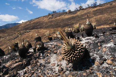
My friend Otis Calef and I are driving on a narrow dirt road up toward Big Pine Mountain for a firsthand look at the damage. We’ve heard various accounts, with some saying most of the high-country pines are dead. Others report that things aren’t as bad as they look, that the Coulter pines, incense cedar, big cone spruce, and ponderosa will come back. “They’re adapted to fire,” one biologist explained. “The bark is thick enough, so most of them will survive.” These trees are important because they provide vital habitat for the California spotted owl, which prefer large, old trees. Big Pine is one of the few places in the county where the trees fit their needs.
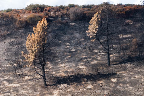
Soon, we start getting glimpses of the fire’s impact. In the areas where crews torched the chaparral as part of the backfiring, there is an uneven pattern to the burn, what fire officials call a “mosaic”-islands of unburned chaparral spotted with charred black earth. Done right, a mosaic leads to healthier habitats while at the same time creating a buffer against the next major wildfire.
On the way to the top of the Sierra Madre Mountains, I start feeling confident that the fire may not have been as destructive as I’d feared. “The fire may have been a blessing in disguise,” says Otis, echoing my thoughts. “I’m seeing a lot more vegetation than I thought I’d see.”
But as we climb higher, my confidence fades. We’ve been looking at the north-facing slopes, which have less sun exposure, more moisture, and better burn resistance. As we go deeper, we start seeing the south-facing slopes-some are completely burned out, with no vegetation left. This north-south pattern repeats itself over and over again. “It’s kind of weird,” Otis says. “You look one way and you see lots of unburned chaparral. You look the other direction and it looks like hell burned over.”
At Madulce Ridge, one of the Sierra Madre’s high points, we walk along a sharp ridgeline on a trail that dips down into the Dick Smith Wilderness. Otis checks out the visitor log and finds the pages burned to a crisp. Below us, the entire hillside is burned out. But down in Alamar Canyon, the sycamore, willows, and a cottonwood or two peek their heads out of the creek. It’s the same way in almost all of the canyon. While the hills burned to a crisp, the riparian vegetation survived. This will undoubtedly be a great help to wildlife.
In Spanish, madulce means “bittersweet,” which describes the taste of the high-country strawberries found nearby. It’s as apt a word as any for my feelings. I’m in a madulce sort of mood as we head down the trail. Intellectually, I know the fire is needed, but it still hurts to see so much of the wilderness turned to toast.
Overgrowth Gone, Trails Too
Together, the San Rafael and Dick Smith wildernesses, which endured the brunt of the Zaca Fire, encompass more than 260,000 acres and feature some of the finest places to explore in all of Southern California: deep canyons, high mountains, thick chaparral, and isolated regions where one’s company is made up strictly of forest creatures. Over the past 30 years, I’ve hiked most of the several hundred miles of trails here, and done so during every kind of weather, from blazing sunshine to snow-filled days. It’s tough country that you learn to love over time, but once the bug bites you, it never goes away.
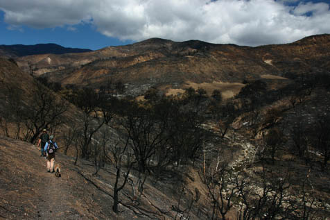
This is also country that’s been getting harder to explore every year. Without wildfires to thin things out, the chaparral’s grown thicker and choked out the trails. Much of the Dick Smith Wilderness, for example, is almost impassable by foot-or, at least, it was just a few months ago.
Today, many hikers are salivating at the idea that the Zaca Fire may have opened up their favorite but overgrown trails. They can’t wait for the forest to reopen. My guess is that they’ll have to wait until the end of winter, but some, like my backpacking friend Paul, already have a list of routes prepared: Hurricane Deck, Fall Canyon, Don Victor, the Mono Alamar Trail, Indian Creek. “Be careful what you wish for,” wrote an Orange County hiker in response to one of my Zaca Fire articles for Independent.com. “Once you get a taste of how a fire impacts the trails, you may wish all you had to deal with was the brush.”
Two weeks ago, I traveled with a group to the top of Little Pine Mountain and checked out parts of the Santa Cruz Trail. Without any vegetation above the trail, gravity alone is enough to cause the gravel and loose soil to slide down the hill-imagine when it starts raining. One of those who hiked down from Little Pine to the Santa Cruz Guard Station wasn’t sure he would make it. “There are whole sections of the trail that are completely covered,” Jasonn Beckstrand told us when he finally reached us down below. “There were times I felt like I’d keep on sliding all the way down the hill. There really wasn’t anything to stop you from going a long ways down.”
The Forest Service’s Kerry Kellogg, who’s in charge of wilderness recreation in the Los Padres Santa Barbara District, put it bluntly. “We could lose the whole trail. After the first big storm, we might not even be able to find it.” Though Kellogg has rehabilitation dollars ready, he’s not sure whether rebuilding the trail would do any good. “I’d planned on reinforcing the waterbars along the trail,” Kellogg explained. “But once I saw how much rock was coming down the hillsides, it didn’t make much sense to do a lot of work and then have it get covered up.”
What About the Wildlife?
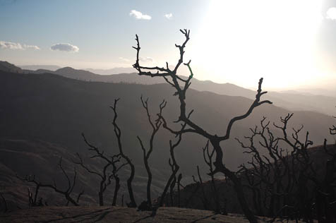
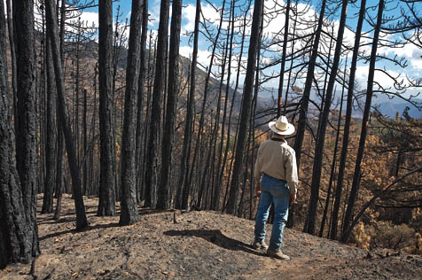
Back on Big Pine Mountain, Otis and I head down from Madulce Ridge to Alamar Saddle, the site of a former Forest Service station, long since removed. An old picnic table survived the fire nicely, but not the trees; the once stately green pines are standing like thin, black sentinels of the night, their needles and limbs entirely consumed by the Zaca Fire. The firestorm that raged here-up from the Sisquoc River, over this saddle, and across the face of Madulce-must have been intense. If there is a good side to this story, it appears the flames moved through so fast that it left the higher and more north-facing side almost untouched.
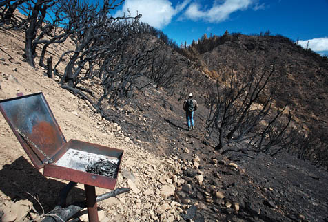
We meander through the pines, savoring the incense smells while driving toward the road’s summit before plunging a steep 2,500 feet down the front face of Big Pine. Just a few feet into the drop, everything changes and neither Otis nor I are prepared. We’ve not only left the pine forests, but we’re entering a moonscape-that is, if the moon were black.
When we finally stop, the 1,000-foot cliffs above us are barren, every vestige of life removed by the fire. Jumbles of rock jut out of the low ridges, totally devoid of covering. The wind is blowing and, beneath us, dust storms kick up. But there is none of the usual sound to it, no leaves to rattle in the breeze, no trees to sway back and forth, no sound of birds chirping from their hidden places in the bushes.
Down below me, Otis sits on a solitary rock to survey the damage. I take a quick picture, then look around. There is nothing green, nothing alive-thousands of acres with no vegetation anywhere, just black, black, black.
“We’re screwed,” I think to myself. “I’m tired of this,” says Otis, breaking the silence. “I want the chaparral back.” I never thought I’d hear him say that. Four months ago, we were nearby, removing brush from one of the impassable trails and cursing it with every cut.
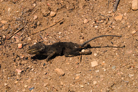
Despite the destruction, I was particularly impressed by one thing I didn’t see: dead critters. During the fire, one of my more popular stories was about a mother bear and her three cubs, which reminded me that issues relating to wildlife hit home the hardest. The Forest Service employee who’s supposed to worry about that is biologist Kevin Cooper, and he’s more upbeat than most. His concern is the loss of habitat more than the loss of life. “The spotted owl populations are fairly mobile,” Cooper explained “They can move several hundred miles pretty easily, though it may be years before we can determine how well they’ll come back.” Judging from what we’ve seen on Big Pine, they may do just fine.
Cooper explained that the bears, mountain lions, and deer are also fast enough to escape. “Ironically, the deer populations really have been well below normal because of the overgrowth,” he said. “They’ll respond really well once the new growth begins to sprout. In five to 10 years, their numbers could be 50 percent higher than they are now.”
The bear and mountain lion won’t be so fortunate. Both are highly territorial and they may need to fight to get established in the places they move to. “They can’t just walk into another’s territory and set up shop,” Cooper explained. “The competition could be very violent.”
Though the bear and mountain lion may face tough times for several years, they will start rebounding once the deer population comes back. “We could see even higher populations of both within the next five years,” Cooper suggested. “At first, they won’t be breeding, they’ll be focusing on survival. But once the deer are plentiful enough, they’ll thrive. Though individual animals may not make it, the species should do well.”
Cooper’s real concern is the impact in the riparian zones. “That’s where most of the T&E live, steelhead, too,” he explained, referring to threatened and endangered species. “Most of the upper Sisquoc River drainage was burned severely and sedimentation will be a big problem. Because it’s in the wilderness, there really isn’t anything we can do but monitor the populations until the hillsides become more stable.”
Burn + Rain = Lots o’ Mud
It’s tough to look out over this vast country from the top of Big Pine and think of something other than magnificent wilderness, but this wild landscape has what others may consider a more practical value: It produces the water you and I use every day. Originally, the Los Padres National Forest was created as the Zaca Lake & Pine Mountain Reserve, not to protect the land, save the wildlife, or keep it for recreational purposes, but to protect vital sources of water. Without a healthy set of watersheds, we’re all in trouble.
Perched at 6,700 feet near the middle of the backcountry, many of the county’s main watersheds originate on Big Pine Mountain’s massive flanks: Mono and Indian creeks on the east and south, Santa Cruz Creek on the southwest, the Sisquoc River on the northwest, and a portion of the Cuyama River drainage on the northeast. Both Gibraltar Reservoir and Cachuma Lake are downstream from Big Pine Mountain and will be immediately affected by any soil erosion that takes place. In the long run, the real impact of the fire may not be its size or cost, but its impact on these watersheds.
I’m especially concerned because I know there’s little the Forest Service can do to protect them. A few weeks ago, I spent time with the Forest Service’s Burned Area Emergency Response (BAER) Team, a group of multi-disciplinary specialists that responds to any forest fire larger than 300 acres. Their mission is to reduce watershed damage from flooding or landslides on recently burned Forest Service land. I was hopeful they’d provide the help we’d need to mitigate the watershed issues.
When I arrived at their makeshift headquarters at the South Coast Inn in Goleta, team commander Rick Weaver gave me an overview of their work. “We’ve got people looking at watershed issues, hydrology, soils, recreation, archaeology, wildlife issues-almost anything that might have been impacted by the fire,” he explained. “One of the key things we do right away is to build a map that shows us the burn severity. We’re using satellite imagery : to help us pinpoint what burned and how badly.” Looking at before and after maps of the area, the BAER team develops a “burn severity” profile-the low, moderate, and high classifications translate roughly to burned lightly, burned a lot, and burned everything.
BAER’s depth of expertise and swiftly assembled information was encouraging, but it became apparent pretty quickly that we had a big-time problem and few solutions. The statistics relating to the Santa Cruz Creek drainage were particularly disturbing since whatever flows down the creek goes directly into Lake Cachuma. Of the 47,800 acres within the watershed (roughly 75 square miles), Weaver explained that 25,600 of the acres had been burned either moderately or severely.
“That’s more than half of the watershed that got hit pretty badly,” Weaver explained. “What’s even tougher is that there really isn’t a lot we can do. Realistically, we can either treat the hillsides or do some form of channel control. Most of the hillsides that burned are too steep to treat and we haven’t found that channel structures, such as debris dams, work that well.”
And for any watershed-salvaging program to be effective, Weaver explained that at least 50 percent of the watershed would have to be treated. “In Santa Cruz Canyon, you’ve got 7,500 acres with no vegetation on it at all and another 18,000 acres that were burned quite a bit,” he said. “Where do you begin?”
From my perch near Big Pine Mountain, the impact is both immediate and startling, an emotional jolt you don’t get sitting in town and discussing statistics. “What’s going to hold those hillsides in place?” I thought. “There’s nothing here.” I realize that when it comes to post-Zaca Fire watersheds, there will be no winners, only big losers and really, really big losers.
To Dam, or Not to Dam
The biggest loser of all could be Santa Barbara, which gets its water mainly from Lake Cachuma and the Gibraltar Reservoir. Cachuma, as explained above, may be harmed by the 25,000-plus acres of scorched earth in the Santa Cruz drainage. Gibraltar has it even worse, relying on the Mono, Indian, and Agua Caliente watersheds, which have more than 65,000 acres of moderate or severe burns. That’s a lot of loose soil.
“It’s a disaster waiting to happen,” agreed Cathy Taylor, the city’s water systems manager. It’s her job to make sure the water keeps running. “If it’s an average year, we could lose half our storage capacity in Gibraltar,” she explained. “And with a lot of rain, we could lose Gibraltar.”
Two weeks ago, I joined Taylor, several city water engineers, and a number of Forest Service personnel on a trip into the upper Gibraltar watershed to look at what options the city has. As we trudged up to the top of the Mono Debris Dam, everyone’s minds were focused on finding a solution that could be put in place quickly, wouldn’t disrupt the habitat too much, and would work for all of the parties.
The city is in an extremely difficult position. It owns parts of certain watersheds, but the lands surrounding those drainages are owned by the Forest Service, so regulations from both the state’s California Environmental Quality Act (CEQA) and the federal government’s National Environmental Protection Act (NEPA) apply. Both regulatory processes are lengthy and onerous, which means that getting anything done before the first storms hit may be impossible.
“Because the governor declared the fire a state emergency, we have some leeway in how we deal with CEQA,” Taylor explained, “but with the forest lands, there’s none.” She’s looking into possible congressional help to ease through NEPA, but that doesn’t look promising.
There is also the issue of dealing with the “T&E”-threatened and endangered species such as the California red-legged frog, least Bell’s vireo, or arroyo toad. Ironically, much of the habitat they use was created as a result of building Gibraltar Dam in the early 1920s and the Mono Debris Dam in the mid-1930s.
With such stumbling blocks, the city’s options appear quite limited, and Taylor is frustrated by the lack of federal help. She was “extremely disappointed in the BAER report,” especially because she heard team members discussing things that never made it into the survey. “It’s kind of like being in a bad car accident,” said Taylor, “and when you get taken to the hospital, they tell you, ‘Too bad, there’s nothing we can do’ and send you home.”
But, said Taylor, “we’ve got to do something. The hydrologists are telling us that in an average year, we’ll get about two tons of sediment per acre coming down-canyon. This year, they’re estimating the numbers will be more like 75 tons per acre.” To deal with the increase, Taylor sees three options: raise the Mono Debris Dam 10 to 15 feet, raise the debris dam in Agua Caliente Canyon, or dredge out some of the upper Gibraltar Reservoir. “Anything that will keep the debris and sediment out of Gibraltar will be good,” said Taylor.
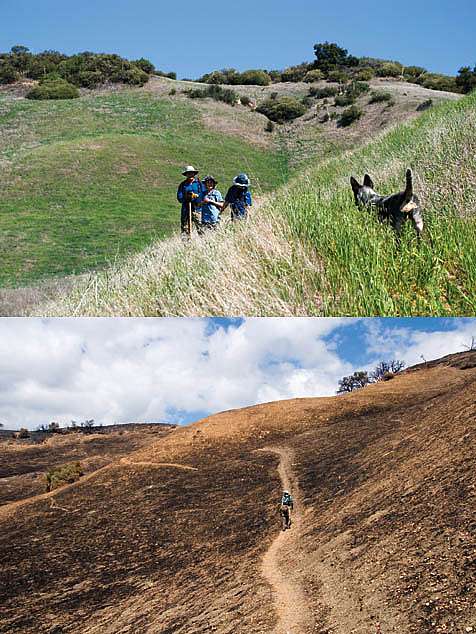
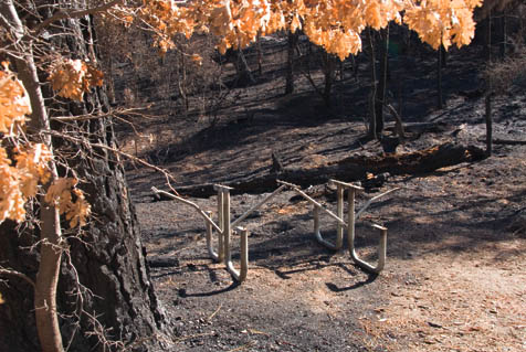
This photo was taken last April during a trail maintenance project.
Below: Post-burn, the same general area of the Santa Cruz Trail is now bare soil.
Whether any of these options are viable is anyone’s guess. Forest Service officials say they will do everything they can to cooperate, but they need to be convinced the work can be done in a way that doesn’t impact the T&E.
Of course it won’t be the end of the world if Gibraltar silts in-it will just hurt a lot. For most of the year, Cachuma can handle Santa Barbara’s water needs. But though Tecolote Tunnel, the link between Cachuma and the South Coast, can handle up to 100 million gallons of water each day, the pipe that takes the water to the filtration plants can only pump 43 million gallons of water per day. That sounds like a lot until you learn demand reaches beyond 50 million gallons on hot summer days. On a day like that, something will have to give. For the first time, we may have to start rationing because we got too much rain.
A Winter Wish
By the end of our first day checking out the Zaca Fire’s aftermath, both Otis and I are thoroughly weary. A long day will do that, but bad news never helps. I know the wilderness will recover and, perhaps in a decade or so, it will be doing just fine. The Los Padres sprang back healthy after 1932’s Matilija Fire, whose impact to the wilderness was similar to the Zaca Fire’s.
But the water woes are a different story, because back then, no one thought much about wildlife issues when repairing watersheds. Engineers solved the problem by building debris dams in Mono and Agua Caliente creeks. Though they filled with sediment within two years of completion, the dams had done their jobs, and Gibraltar Reservoir was protected.
It will not be so easy to do this time. Even if the city is allowed to raise a dam or dredge the upper reservoir, it probably won’t be enough. “We’ll do whatever we can,” promised Cathy Taylor. “Every bit of debris or sediment we stop upstream is a bit that doesn’t make it into the reservoir.”
Though I know we need the rain, here’s wishing us a mellow and mild winter season.


