• CREATE AN ACCOUNT
  • LOG.IN
  • CONTENTS
  • CLASSIFIEDS
  • ARCHIVE
  • INFO | ADVERTISING | CONTACT US

  • Home
  • News
    • News Main Page
    • NewsFlash
  • A&E
    • A&E Main Page
    • Movie Times
    • TV Listings
    • A&E Blog
    • Art Galleries
    • Best Bets
  • Opinion
    • Opinion Main Page
    • Endorsements
    • Blogs
    • Columns
    • Voices
    • Letters
    • In Memoriam
    • Obituaries
  • Events
    • Today
    • Search
    • Submit
    • Best Bets
  • Living
    • Living Main Page
    • Outdoors
    • Travel
    • Sports
    • Peeps
  • Food & Drink
    • Food & Drink Main Page
    • All Restaurants
    • Delivery
    • All Bars & Clubs
    • Drink Specials
    • Open Now
  • Sports
  • Outdoors
    • Outdoors Main Page
    • Outside Insider
    • Spotlight On
    • Features
  • Classifieds
    • Real Estate
    • Jobs
    • Autos
  • Obits

Kira Jones

Jesusita Fire Rages “Out of Control”

Afternoon Winds Blow Wildfire Toward Mission Canyon and East; Evac Orders and Warnings Expanded Dramatically


Wednesday, May 6, 2009
By Matt Kettmann (Contact), Chris Meagher (Contact)
Article Tools
Print friendly
E-mail story
Contact an Editor
iPod friendly
Comments
Bookmark This
del.icio.us. del.icio.us.
Digg! Digg!
furl furl
google google
newsvine newsvine
reddit reddit
technorati technorati
Facebook Facebook
Yahoo! My Web 2.0 Yahoo!

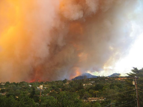
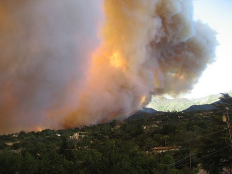
After morning optimism, the afternoon has turned to disaster in the mountains above Santa Barbara, as the Jesusita Fire has reached explosive proportions.

“This thing is way out of control,” said city fire spokesperson John Ahlman at about 4:15 p.m. “All we can do now is try to save some homes.” It’s not far from Mission Canyon, explained Ahlman, and the wind is blowing south-southeast, in that direction, with gusts approaching 60 miles per hour. Spotting of fires, in which flames travel distances and ignite new areas, is occurring rapidly, and eyewitness reports say that homes are already burning, though that has yet to be confirmed. The air attacks have also been cut due to the high winds.

Kira Jones

In response to the fanned flames, the mandatory evacuation has been extended dramatically. Authorities are now ordering residents to leave all homes located east of Alamar Avenue, from Foothill Road south to State Street, State Street to Constance Avenue, Constance to Los Olivos Street, Los Olivos to Alameda Padre Serra, APS to Sycamore Canyon Road, north on Sycamore Canyon to Highway 192 at El Cielito. The evacuation warning has been expanded to include La Cumbre Road to State Street, State to De La Vina Street, DLV to Anapamu Street, Anapamu to Anacapa Street, Anacapa to Del La Guerra Street, DLG to Milpas Street, Milpas to Montecito Street, and Montecito Street to APS. Traffic on the streets and highways of Santa Barbara are reportedly deadlocked, so residents are urged to leave as soon as possible, because it may take some time to get to a safe area.


View Jesusita Fire map in a larger format (current as of 9pm, May 10)
Click on icons or colored areas to get further info

At about 4 p.m., Ray Ford called from his post with firefighters atop Inspiration Peak. He said he was surrounded by fire on all sides, but that he was safe in an already burned area. Ford had seen spotting reach all the way east toward Montecito, and feared that fires may be starting there. Rattlesnake Canyon now seems to also be engulfed in flames.

Another report said that the fire had reached where the asphalt ends at Tunnel Road and the Edison Trail.

Kira Jones

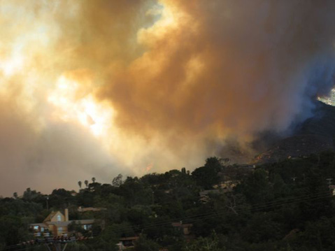
Flames were visible from downtown by about 3 p.m., and smoke clouded the skies. The power went out sporadically in various neighborhoods. Temperatures were breaching 95 degrees and humidity was dropping precipitously.

Meanwhile, the mobile home fire — caused by exploding propane and gas tanks — near the intersection of State Street and 101 was properly extinguished, after a thick black cloud of smoke emerged from burning tires. It burned about 20 feet of brush, according to

For more info, see independent.com/jesusita or tune into KCSB 91.9 FM. Readers are encouraged to submit their own stories and photographs to fire@independent.com.

Related Links

  • More Jesusita Fire coverage
Story Help (Click-ability)
Double-clicking on any word or phrase in this story will open a reference window with definitions and links to other reference material.

Comments

Discussion Guidelines

What about Westmont? Fire is right up next to buildings, last I heard (20 minutes ago). -----
---------------------------
PLEASE NOTE:

** Westmont is not at this time threatened by the fire; it is 2 or 3 miles away. ***
--WebAdmin

james516 (anonymous profile)
May 6, 2009 at 4:45 p.m. (Suggest removal)

Oh my

CGerlach (anonymous profile)
May 6, 2009 at 4:49 p.m. (Suggest removal)

It's really hard to tell from your description where the evacuation area really is. How about a map?

bisonfilms (anonymous profile)
May 6, 2009 at 4:59 p.m. (Suggest removal)

Map here: http://maps.google.com/maps/ms?ie=UTF8&l...

RobbyR (Robby Robbins)
May 6, 2009 at 5:13 p.m. (Suggest removal)

Yeah, I don't like the descriptions either -- not very helpful. I found this map from the SB County's information page:

http://maps.google.com/maps/ms?ie=UTF8&a...

More info here:
http://www.countyofsb.org/ceo/oes0.aspx?...

jasonsteel (anonymous profile)
May 6, 2009 at 5:19 p.m. (Suggest removal)

I am at Westmont sitting in my room. The flames are not near to us, at least not near enough for us to be evacuated.

I wouldn't be surprised if we are evacuated soon. We are waiting to hear from the phone/text message system whether or not the fire is close enough for us to be concerned.

For now "Campus is operating normally<br><br>We are under no evacuation warning<br><br>All services are operating normally <br><br>In addition finals scheduled for tonight and tomorrow are still on."

Haley

hdevinney (anonymous profile)
May 6, 2009 at 5:33 p.m. (Suggest removal)

Kcoy.com shows live streaming of burning houses; unfortunately, they do not explain the streets.

GoletaResident (anonymous profile)
May 6, 2009 at 5:35 p.m. (Suggest removal)

I am glad to hear that the fire was not as close as I was led to believe. Please keep us updated! Thank you.

james516 (anonymous profile)
May 6, 2009 at 6:40 p.m. (Suggest removal)

the google map doesn't show the burn area...anyone know where that is?

Akimbo (anonymous profile)
May 6, 2009 at 6:57 p.m. (Suggest removal)

We have gathered our belongings in the light of our firing ways.

Gaea, please be kind to the springtime birds who have yet grown wings to fly!

Create a fire break that protects, but does not burn too deep into our shared skin.

Please protect us Gaea; protect the innocent Others and children of the Sun;

...boiling over river, fire poppy, horned ones, and winds of ash.

Let us pass without too much of your flurry and flame to blacken and block our broken path.

Let us pass into the River, to heal and restore, to form a great circle that you can embrace.

Let us pass deep into your canyon and rejoice in a chorus of song and dance once again.

Fire and water unite. A common archetype in this springtime fire. Let us find comfort in the sundowner that lies ahead!

0071 (anonymous profile)
May 6, 2009 at 6:58 p.m. (Suggest removal)

James-

I just drove on E. Mountain above Westmont to see where the fire was, it's just over the big bowl that was burned in the Tea Fire. It's probably only a mile or two total from campus, but there's nothing to burn in its path. It's still possible for it to reach campus, of course, but it would have to travel around the already scarred area and run parallel with 192 for a while. Wind was almost completely dead up there.

JohnO (anonymous profile)
May 6, 2009 at 9:39 p.m. (Suggest removal)

I'm not sure which is worse, the Jesusita fire or that poem.

rodney_x (anonymous profile)
May 6, 2009 at 10:30 p.m. (Suggest removal)

agreed, i wish someone would pls delete that babble. this is too serious for such stuff.

CGerlach (anonymous profile)
May 7, 2009 at 1:58 p.m. (Suggest removal)

Scary thing is I think the poster was serious.

SithSnoopy (anonymous profile)
May 7, 2009 at 5:48 p.m. (Suggest removal)

We live just south of State Street in San Roque. Got a reverse 911 evacuation warning at 2:40 AM. Just a warning at this point. I wish there were more helicopters and water bombers out there. Pilots are a LOT cheaper than firemen, they could be employed seasonally, and there are hundreds of old but still useable helicopters in the arizona desert. The firemen can't put out fires from the ground when the fires are in the back country, and they're not willing or able to keep it from the homes up in the hills. So far the fire is winning about 75-10.

helobubba (anonymous profile)
May 8, 2009 at 3:18 a.m. (Suggest removal)

Post a comment

Username:
Password: (Forgotten your password?)

Comment:

Independent Interactive:

  • Jesusita Fire - Evacuation Area Map
  • Sign-up for IndyAlert for Jesusita Fire Updates
  • Send us your Tips, News, or Photos & Video

Public Resources

  • The Jesusita Fire Call Center
    (805) 681-5197
  • County of Santa Barbara
  • City of Santa Barbara
  • Santa Barbara County Fire Department

    Phone Numbers:
  • Public Information Hotline
    (805) 681-5197
  • Reverse 911 sign-up (If you don't already have a house phone, and want to add your wireless device to be contacted for emergencies)
    (805) 681-4100 or http://www.sbsheriff.org/reverse911.html
  • Forest Service Tip Line
    (805) 961-5710
  • Animal Shelter Hotline
    (805) 681-4332

    Websites:
  • SB County Fire Department
  • Santa Barbara County Air Pollution Control District
  • Smoke Information from County Health
  • Wildfire Smoke Impact
  • Prepare Your Family Disaster Plan

    Radio Stations:
  • AM Stations: KTMS-990; KZSB-1290; San Marcos Pass Radio-1040; KUHL-1410 and KINF-1440;
  • FM Stations: KCSB-91.9; KTYD-99.9; KSYV-96.7; KSBL-101.7; KRAZ-105.9;
  • (Spanish); KSPE-94.5 and KIST-107.7;

    TV:
  • Santa Barbara County's Channel 20
  • City of Santa Barbara, Channel 18
  • City of Goleta at Channel 19

    Additional Info:
  • In the event of a possible evacuation due to the Jesusita Fire the Public Health Department wants to identify individuals with special needs who may be unable to evacuate without help and those who need medical equipment that require electricity. please call (805) 968-0462 between the hours of 8 a.m. and 8 p.m.
  • The Red Cross Evacuation center is Dos Pueblos High School at 7266 Alameda Avenue in Goleta, CA.
  • The cause of Jesusita Fire is currently under investigation. If you have information about the fire, please call the anonymous tip hotline 805-686-5074.

EVENT CALENDAR

Previous Month | Next Month

Today's Events Best Bets Submit an Event

Local Weather

Currently:
Clear Sky
Temperature:
64.0°
Wind:
7 SSE

Surf Report
  • Specials
  • InPrint
  • Top Emails
  • Best Of 2009
  • 2009 Election Coverage
  • Wedding Guide 2009
  • Blue Green Guide 2009
  • SBIFF 2009
  • Tea Fire 2008
  • Local Heroes 2008
  • Calendar of Fundraisers
  • Local Bands
  • Within the Syuxtun Story Circle
  • Camellia Sasanqua
  • Whole New Ballgame
  • Gratuitous Gore on Highway 154
  • Saul Williams Brings Afro-Punk Tour to Velvet Jones
  • Where There’s a Dill, There’s a Way
  1. Travis Armstrong Is Outta There
  2. S.B. Bank & Trust's Rocky Year
  3. UC Campuses Dominate Rankings
  4. What buildings did architect Julia Morgan design in Santa Barbara?
  5. Giving Back in the Giving Season
  6. Rattlesnake and San Roque Side of Jesusita Trails to Re-Open Friday
  • CREATE AN ACCOUNT
  • LOG.IN
  • CONTENTS
  • CLASSIFIEDS
  • ARCHIVE
  • INFO | ADVERTISING | CONTACT US
Google
 
Independent.com Web
Copyright ©2009 Santa Barbara Independent, Inc. Reproduction of material from any Independent.com pages without written permission is strictly prohibited. If you believe an Independent.com user or any material appearing on Independent.com is copyrighted material used without proper permission, please click here.
This is our Privacy Policy.