

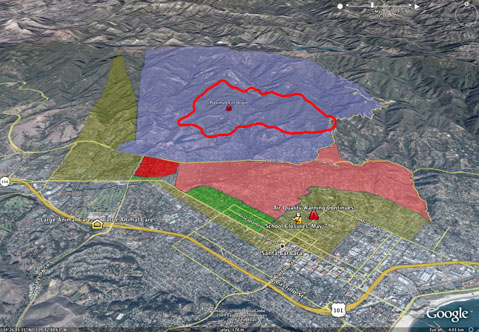
MANDATORY EVACUATION:At 8 p.m., the mandatory evacuation order was extended west, to all residents north of Foothill Road and east of Highway 154. That includes such roads as Cieneguitas, Northridge, and Cocopah.
Although the scary weather promised today does not seem to have landed yet, the Jesusita Fire is continuing its stomp up the Santa Ynez Mountains behind Santa Barbara, and may soon become a problem for residents of Goleta as well. That’s the word from Independent reporters Ray Ford and Chris Meagher, who are currently watching the fire from as close as safely possible. Ford is atop La Cumbre Peak, while Meagher is down near the end of Ontare Road, and both are reporting that firefighters are fearing the Jesusita could get crazy again tonight, after a relatively mild day.
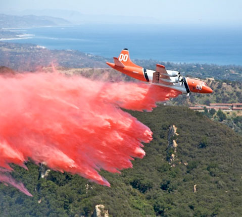
At about 6 p.m., Meagher called from a horse stable on Santa Teresita Drive, where a load of engines suddenly brushed by him on the road, and all eyes were on the fire’s mountaintop spread. Helicopters reloading at Lauro Reservoir were “just killing it,” many engines were still stationed in driveways, ready for another stand against the flames. The fear was that the entire upper Ontare Road neighborhood could be in danger if there’s any southern shift in wind direction. Said one Sheriff’s deputy, “If the wind changes, it would only be a matter of minutes.”
Ford, overlooking the entire fire from the highest peak around, was even more dire in his prediction: “It looks like bad things are happening.”
Ford said that the fire had been moving up the west fork of San Roque Creek all day, where the San Roque Ranch sits and historic Arroyo Burro Trail traverses. From his perspective, it appeared that the Jesusita could cut across the mountain in a westward direction and into Barger Canyon, and perhaps even further into San Antonio Creek Canyon. “It’s really heavy, heavy fire,” said Ford, describing 50- and 60-foot flames. If it got into San Antonio Creek, Ford said that it would reach the Windy Gap fuel break. With fire spread across the top of the mountains like that, any downward shift in wind could expose homes on Northridge Road, Barger Canyon, and perhaps all the way to San Antonio Creek, if it hopped Highway 154. “It is now becoming a Goleta fire as well as a Santa Barbara fire,” said Ford.
As for the Santa Barbara side of things, Ford said that the flames have reached the rocky outcrops he calls the Rock Garden, also known by some as Rocky Pine Ridge, where the pines are already burning. Cathedral Peak, already toasted, was once again burning with 15-foot flames. Yesterday, the fire went through the top of Mission Canyon along the power lines and into Rattlesnake Canyon below Tin Can Flats, where it continued to Gibraltar Road and was stopped. Ford thinks that may be happening again, albeit much higher up the mountain, closer to Mission Falls near the top of Tunnel Trail. He doubts it will re-enter Mission Canyon – although the fire wasn’t a clean burn, so there is more fuel there – but fears it may be moving sideways into upper Rattlesnake.
As such, there is a large contingent of engines at Skofield Park, ready to handle a surge back toward Santa Barbara. Above Skofield, the terrain is charred, and was smoldering around 4 p.m. But firefighters were there watching and ready.
Somewhat complicating matters was a vehicle fire at Highway 154 and East Camino Cielo a couple hours ago. A radiator hose blew, the vehicle ignited, and thanks to so many nearby fire folks, it was quickly put out.
UPDATE: Ford called at 7:25 p.m. to report that the fire is “definitely” in the east fork of the San Antonio Creek drainage and continues to “push pretty strong” toward the crest of East Camino Cielo. It’s about half an air-mile from the crest, Ford said, while coughing a bit. The fire continues to move west toward Goleta.
Meagher just left the Ontare Road neighborhood at 7:30 p.m., because he was fearful that the fire was coming too close too fast. “It’s coming down close to road a little further west,” he said, meaning the Northridge Road area. The wind and smoke were blowing every which way, he said, making it unclear where the escape route would be. Even firefighters seemed to be re-dispersing, somewhat bewildered. “It’s just getting crazy,” said Meagher, with a mix of fear and confusion in his voice. “It’s impossible to tell what it’s doing.”
But David Sadecki, the County Fire spokesperson, said at 7:20 p.m. that the mandatory evacuation area has not been expanded to the west, as of yet. “We have plans in place if we have to expand the mandatory evacuations,” said Sadecki. “But as far as right now, no trigger has been pulled. The one thing we have to remember is the difference between last night and tonight: this is a light wind out here right now. We are experiencing a wind shift [to the southeast], but the velocity is not like last night.”
At 8 p.m., however, the mandatory evacuation order was extended west, to all residents north of Foothill Road and east of Highway 154. That includes such roads as Cieneguitas, Northridge, and Cocopah.


