

PLEASE NOTE: Due to damage caused by the recent fire, Jesusita Trail is still closed on the Mission Canyon side. The trail is open from Cater Filtration Plant up to Inspiration Point. Please refrain from using it until it re-opens.
TRAIL INFORMATION
Distance-4 .5 miles
Elevation Gain-100′ to end of canyon; 1225′ to Inspiration Point
Difficulty– very easy to moderately strenuous depending on the distance
Topo– Santa Barbara
View Photo Gallery
HIGHLIGHTS
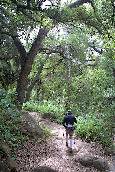
Jesusita Trail wanders through a beautiful oak-filled canyon, whose combination of picturesque scenery and easy hiking is perfect for children. The hike to Inspiration Point provides views that make the ascent worthwhile. Along the way you will find a cutoff trail leading up to the historic Arroyo Burro Trail. Stevens Park is at the lower trailhead, making this a perfect place to go for an afternoon picnic, game of volleyball, or canyon hike.
DIRECTIONS
From the freeway drive 2 miles north on Las Positas to the posted trailhead, which is just beyond the Cater Filtration Plant. The trail begins .5 miles above Foothill Road.
SETTING THE SCENE
The San Roque area has known the tread of all of those who have come before: the Chumash Indians whose camps dotted the open grasslands; the Franciscan padres who sought to convert them to a pastoral way of life; the Mexican rancheros which supplanted the Chumash when this disastrous experiment was ended in the 1820s; and the soldiers of John C. Fremont who “liberated” Santa Barbara from Mexico in the 1840s.
Today there are large homes jutting out on either sides of San Roque Canyon and what is left of the pastoral life is comprised mainly of avocado ranching. But as you enter the canyon and begin to walk along the creek’s edge the feeling of being in a very special place still remains.
THE HIKE
Unlike the other foothill trails, which begin in the lower canyons and then extend upward through the chaparral to East Camino Cielo or Gibraltar Road, Jesusita Trail is a loop of sorts, connecting San Roque and Mission Canyons via Inspiration Point and its awe-inspiring panoramas.
The Jesusita isn’t a historic trail but was built in 1964 as part of an $8,000 project financed by the State Division of Beaches and Parks after an exchange of easements between the County and the Marion Moreno family, who owned most of the upper canyon.
The first section of the trail drops down into the canyon and follows a lazy course along the right side of the creek with one small exception-there is a steep knoll which you will need to go up over. This detour was created when the main trail washed out in the 1995 floods. There is a creek crossing or two along the way, which the kids will like and lots of Sycamore trees and huge old oaks to shade you. Look for the old picnic table along the way which was buried by silt in 1995.
In a half mile the trail turns right, heads up onto a long plateau covered with annual grasses then retreats back into the canyon. You should be a trail sign under a large oak. The left fork leads up to the Arroyo Burro Trail and the right one up to the grass plateau.
A half mile of hiking takes you in and out of a series of oak forests and back and forth across the creek several times to the Moreno Ranch, marked by a horse corral. This is the end of the lower canyon section of the trail.
The upper chaparral section begins just above the point where the creek branches. Turn right just beyond the fenced corral and follow the dirt past a gate into the east fork of the canyon. Just as you cross the creek you will spot a trail sign and the well-worn trail. The owners would be extremely grateful if you would stay to the trail rather than meandering onto their property.
The first several hundred yards leads along the creek through an oak forest and grassy openings then begins to climb much more rapidly as you make your way through a thin but spectacular layer of Vaqueros Sandstone. The sandstone marks your final exit from the canyon vegetation and the start of the hard chaparral.
This area is dominated by chamise, ceanothus, holly-leaf cherry, and manzanita. The trail winds back and forth up a set of switchbacks and then levels somewhat, turns east, and continues along the Sespe redbeds before widening to become a power line road. This signals the start of another section of bedrock-the Coldwater Sandstone. Towering overhead are the precipitous Mission Crags. The toothlike shape of Cathedral Peak can be seen a thousand feet above.
At the base of the 300-foot-tall spire is an enormous cave, almost 60 feet in length and more than 30 feet deep, which, according to legend, harbored stolen horses during the early 1800s. It is seldom visited now because of the thick chaparral. In 1966, two years after the Coyote Fire, News-Press writer Dick Smith, made the trek when the more open landscape made it possible. “The view from Cathedral Peak is truly sensational, much closer and equally as high as that from La Cumbre Peak,” he noted.” One can look down on the entire city, unobstructed by any foreground ridge.
“Getting to take a look at this fabulous view is not an easy task,” he mused afterwards. “In fact it took…nearly two hours of rock hopping to gain the end of the ridge….There’s no trail. You must pick your way across the brush.” Today, thanks to the efforts of climbers and other trail enthusiasts who have carved routes through the chaparral up to Cathedral Peak, it is possible to gain the summits Dick Smith once sat upon.
Another few hundred yards along Jesusita Trail leads to Inspiration Point, which is actually not at the highest point but rather at the east end of the knoll where the power line road ends. To find it, rather than dropping down into Mission Canyon on the trail, walk east on the dirt road and look for a small trail that leads to a series of boulders that marks the view point. You’ll know you are there if you spy the initials carved a half century ago in the bedrock.
From Inspiration Point, Jesusita Trail continues another three-fourths mile, winding down into the west fork of Mission Creek and the beginning of Tunnel Trail. For a refreshing dip before the hike back, Seven Falls is but a half-mile up the creek.


