

Tuesday, July 1: Thick Brush, Big Flames
When Rocky Siegel of the Painted Cave Volunteer Fire Department arrived at an old shooting range on West Camino Cielo at 6 p.m. on July 1, he knew this was going to be a bad fire.
The call reporting what was to become the Gap Fire, which as of press time had consumed more than 10,000 acres, came at 5:32 p.m. The Santa Barbara County Fire Department said that a vegetation fire had just started near Windy Gap. At fire headquarters, an expanded dispatch was sent out immediately calling the incident the Gap Fire, though it quickly became clear that the location was much further west and near the top of the Santa Ynez Mountains.
At 5:44 p.m., the first county fire helicopter arrived dropping water, followed by a Cal Fire air tanker from Paso Robles with retardant. At 6:55 p.m., a second tanker made another drop. But by this time, the fire was burning intensely, moving away from the road down a gully toward Goleta.
Soon, a wildland fire crew of seasoned hotshots from the Lake Cachuma county fire station were on the scene, chainsaws at the ready. In a blaze such as this, firefighters begin by establishing an initial attack, during which they establish a safe anchor zone where they can retreat, if necessary. Then the crew begins to build a containment line around each side of the fire, flanking it so the perimeter can’t expand laterally. If successful, the next step would be to begin pinching off the head of the fire in the direction it is moving until the perimeter is fully enclosed.
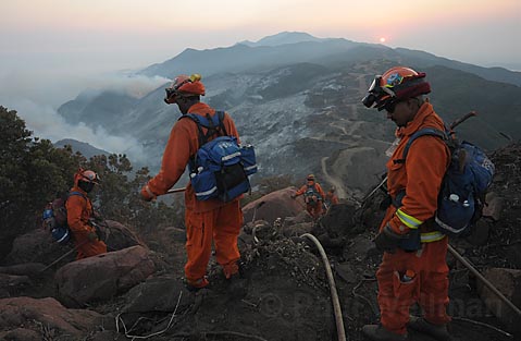
The crew’s supervisor, Mark Linane, quickly saw there was no chance of that. With only a few hours of daylight left, the fire had now fully established itself several hundred yards off the road, heading down into 15-foot-tall brush and rocky terrain with no potential for safe retreat for his crew should the wind shift uphill.
By 8 p.m., two bulldozers arrived to build a 40-foot-wide line straight from the point of origin. Several hundred yards into the brush clearing, the dozers ran into rocky ledges, forcing them to back out but leaving enough space for hotshots to continue cutting the containment line by hand.
Shortly after midnight, the fire settled into the rocky ledges and began moving slowly east and west on the outcroppings, firmly establishing itself at a point where it was extremely unsafe to work. By 3 a.m., the powerful smoke and flames forced the hand crews back up to the road.
Wednesday, July 2: Getting Hotter, Losing Power
At 6:30 a.m. on Wednesday morning on the top of West Camino Cielo, I followed several hand crews as they headed down the dozer line to continue cutting the line. With the sun up, crews could move about more safely. By 7 a.m., the helicopters were in the air, followed by spotter planes checking out the terrain to guide the bombers to their targets. Unfortunately, by then it was also 86 degrees, the humidity was dropping, and the wind was beginning to shift to a downhill mode.
A common misconception is that helicopters and fixed-wing aircraft can put out a fire from the air. With few exceptions, what air support provides is the ability to cool the fire down and, with retardant, coat the vegetation with a thick layer of what looks like sticky red mud to inhibit burning. In brush this thick, neither water nor retardant can snuff out fire, but used together they can slow it down enough for hand lines to be built and the perimeter to be flanked.
Wednesday’s goal was to force the fire into a straight downhill run toward the ranches. Although seemingly counterintuitive, it made perfect sense because there is a mile or so of ranchland buffer between the mountains and homes where grazing has kept the dry fuel down to a manageable level. While the hand crews worked on flanking the east side of the fire line, crews from El Centro, Ventura, and San Luis Obispo were stationed to the west of where I stood. Large attack planes began flying in, dropping load after load of retardant straight downhill.
By 11 a.m., the fire had spread far enough downhill that it was safe for me to peak up over the rock ledges. It was a dismaying sight. The ridgeline directly below was completely burned and the fire was now in the canyons on either side. By 1 p.m., it looked as if the crews had lost this battle.
During the 2 p.m. press conference at Dos Pueblos High School, I could see flames beginning to appear just a thousand feet above the power lines in upper Glen Annie Canyon. In just one hour, the fire had spread west at least a mile and was also moving east almost directly above Fairview Avenue. Ironically, one of the politicos talked about the importance of developing a Family Emergency Plan, but the power grid was barely discussed and no one even glanced backward toward the fire line that was marching toward Goleta. How would Reverse 911 calls, evacuation orders, or other information get to the public in a blackout?
Rather than heading downhill to the ranches, where the forces amassing along Cathedral Oaks Road could deal with it, the flames followed lateral channels east and west along saddles formed by erosion of softer rock materials, turning what was a half-mile-wide fire into a raging three- to-four-mile-wide front.
In the Ellwood area, rancher Ken Doty, his son, and son-in-law spent the night building dozer lines to protect his property from the advancing flames. Four miles east, at the top of the Fairview area, neighbors wandered out into the street, dumbstruck by the huge flames they could see on the hills immediately above them.
Shortly after this, the first flames began to appear near power lines in the Glen Annie area. Then the power went out. Goleta started shutting down. Phones reliant on the power grid were dead. Other than the freeway, every light from La Cumbre to the far western end of Goleta was out. Thousands of residents lined Cathedral Oaks watching the fire burn across the hills, a horrific light show that few will ever forget.
In just 24 hours, the community went from preparing for the Fourth of July to facing a disaster.
Thursday, July 3: The Makings of a Catastrophe
On Thursday morning, the community woke wondering if Goleta was still there. Frankly, I was amazed that no houses were lost. The ranches did their job in creating an almost perfect buffer between the urban buildings and the wilderness above. Shortly after noon, I visited the Doty ranch. From a high point we could see that most of the upper canyons above his orchards had burned to mineral soil.
Dozers were moving in and engine crews from San Luis Obispo were backfiring uphill toward the burn area to build a buffer between the fire and lower Ellwood and Winchester canyons. Though the fire was still spreading to the west, the feeling was that the crews should be able to follow along with the fire and build enough line to keep it out of the Rancho Embarcadero and Eagle Canyon areas as well. With the Ellwood area now secure, all attention shifted to the east end of the fire in the North Patterson area.
Just after 5 p.m., I left the Doty ranch and followed Cathedral Oaks to Fairview. It soon became clear that the main fire activity was a ridge where wind was carrying the flames southeast down a side canyon toward the North Patterson area. Even worse, as I drove further east on Cathedral Oaks, I could see flames beginning to jump canyons, heading into the San Jose Creek area. The San Marcos Trout Club would be in danger within a few hours, and if the fire kept moving, Painted Cave as well.
The power went out for a second straight night. The thick smoke and ash were causing the power lines to arc. Automated equipment further along the lines switched off power also. Though the towers and lines weren’t damaged by the fire, they could not be re-energized until the fire moved away from them. Then, at 8 p.m., for the first time since the fire began, a major sundowner kicked in. Suddenly what had been a relatively quiet day now had the makings of a major catastrophe.
At the bottom of Old San Marcos Pass Road and Cathedral Oaks, the winds were gusting to 50 mph. In the dust and smoke, I could see cars streaming down Old San Marcos and forming chaotic congestion as dozens of other homeowners frantically tried to get up the hill past roadblocks to retrieve valuables, pets, and family members. The Sheriff’s deputy directing traffic had the unhappy job of denying access. It was heartbreaking to listen to their pleas, but with no other choice, they parked along Cathedral Oaks and trekked up to their homes to carry out whatever they could.
Up on Old San Marcos Pass, the wind was fierce. While most of the fire activity was still on the Goleta side of San Jose Creek, the fire was spewing coals at a furious rate and the canyon was lighting up like a Christmas tree. The advancing flames were headed directly for homes at the top of West Camino Cielo. Further west, I could see that another large firestorm had almost reached the crest near Windermere Ranch. Behind that sits Kinevan Ranch, which is atop the canyon that leads directly down to Cold Spring Tavern. It looked like it wouldn’t be long before these areas would be burning.
Almost miraculously, the winds began to shift at about 9 p.m., and the smoke shifted to a downhill flow. One community’s good fortune, however, began to look ominous for another. The houses below became the risk, and, moreover, winds act in mysterious ways. “The winds might be heading down the hill right now,” said one firefighter that night, “but whether it is tonight or tomorrow, they’ll shift again, and there will still be plenty of coals left for another uphill run.”
Friday, July 4: Hellfire Holiday
Though no one knew it at the time, Fourth of July would become the Gap Fire’s turning point. At the morning briefing, the Forest Service’s incident commander Jim Smith told the assembled firefighters that today would be a critical day, with one of the main focuses being to seal off Old San Marcos Pass Road. “We are still the number-one priority in the state,” he reminded them.
I visited the western portion of West Camino Cielo, extremely steep country, filled with thick brush that had not burned since the Refugio Fire in 1955. There, California Department of Forestry crew leaders huddled over maps with Forest Service District Ranger John Bridgewater trying to find anchor points where fire crews and dozer operators could begin building a line. The objective was to keep the fire from spreading west of Dos Pueblos Canyon or north of Camino Cielo. Pointing to the almost vertical 1,000-foot headwall that leads out of Tecolote Canyon up to Condor Point, Bridgewater explained that if the fire crossed the creek, it would probably take less than an hour for it to burn up to the summit. “You really don’t want to be up there,” he warned.
Thus far, winds had favored firefighting efforts. “It turned out we got the perfect wind conditions,” said Los Padres District Ranger Cindy Chojnacky. “They were strong enough on top to push it back downhill but weak enough that they didn’t overrun the houses.”
Along the eastern edge of the fire line, the winds continued to favor firefighters, with ridge top flows of 15-20 mph that kept the advancing flames from continuing uphill toward the Haney Tract or into the Trout Club area.
From the deck of one of the homes, I watched as plane after plane swooped down, each pouring thousands of gallons of the bright red retardant on the chaparral. Not too far away, a pod of five huge helicopters swarmed over the edge of San Jose Creek, dampening the eastern edge of the fire line and catching spot fires as they started in the canyon itself. By evening, both the Trout Club and the Haney Tract had been spared.
Saturday, July 5-Wednesday, July 9: Getting Better All the Time
For the most part, firefighters working Saturday through Tuesday have been conducting mop-up operations thanks to favorable winds that push the smoke and ash toward town. Though irritating for residents, this makes it possible for the firefighters to hold West Camino Cielo, backfire the most stubborn parts of the north flank, and attack the head of the fire in upper Winchester Canyon.
While it is possible for conditions to change, there is a growing sense that firefighters now have the upper hand. Containment lines are increasing dramatically each day, fire activity is not nearly as intense as several days ago, and additional crews are on their way to reinforce the efforts to hold the ridge above Winchester Canyon and keep the fire east of Eagle Canyon.


