

I’d finished off my last water bottle a while ago. The Sisquoc River was in my rearview mirror, and the sweeping Salisbury Potrero beckoned, its rolling meadows and sandstone pinnacles a dreamscape among the living. I was in the midst of connecting the Los Padres National Forest to the last of California’s grasslands on the Carrizo Plain National Monument — two mountain ranges down and one to go.
But I desperately needed water, and the available springs weren’t proving fruitful. Fortunately, it snowed recently atop the Sierra Madre Ridge, so while I walked west toward the Montgomery Potrero, I found some shade along with patches of crunchy snow.
No-Name Trail
For years, I was curious about the squiggly line on the map available at the Goodwin Education Center in the Carrizo Plain. It marked a trail off Highway 166, heading northeast, but it quickly ran out toward the Caliente Mountains.
I tried the Forest Service but came up empty. I finally tracked someone down at the Bureau of Land Management (BLM) office in Bakersfield. “It’s an old BLM trail built in 1968,” said Ryan Cooper, outdoor recreation planner for the BLM in Bakersfield. “It hasn’t been maintained for a long time.”
This Caliente Access Trail, I learned, is part of the Chimineas-Carrizo Plains Ecological Reserve, where seasonal hunts of dove, quail, wild pigs, and rabbits are allowed. “The trailhead is difficult to see,” explained Cooper. “It’s not next to the highway. It’s tucked back in a draw.”
Santa Barbara to Carrizo Plain
My wife, Lori, dropped me at Nira in February, and I would meet her four days later on the breathtaking grasslands. Following the sounds of cool water spilling over rock along the Manzana Creek, it wasn’t long before I was up and over the San Rafael Mountains, where sandstone monoliths, pinnacles, and cliffs dominated the rugged landscape.
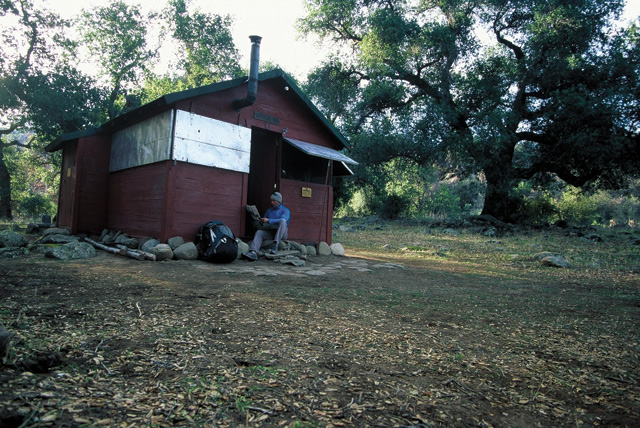
By nightfall I converged with the South Fork of the Sisquoc River, where the empty Forest Service cabin welcomed me inside. A wood-burning stove quelled the icy air. It was a nice pit stop to rest and warm up, eat, sleep, and recharge, the steady flow of the Sisquoc lulling me to sleep beneath sturdy oaks.
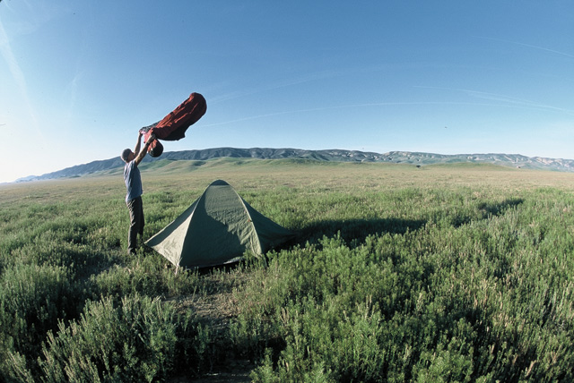
Before the sun beamed on the craggy ridgetops, I was awake and closing up the cozy cabin. After crossing the Sisquoc, I took the Sweetwater Trail, ascending the Sierra Madre Mountains. It felt like a long haul before reaching the potreros. It felt even longer when I couldn’t locate any water.
But that snow rejuvenated me. I scraped as much as I could into whatever I could and hauled it over near the Rocky Ridge Trail. It felt too hot for February. It was 70 degrees atop the Sierra Madre, and I needed more liquids. I went over to the Montgomery Spring, which has always been a trickle, and discovered a plastic jug full of water. I drank it down and positioned the jug to catch more spring-fed water ready by morning. When I returned the next morning, I discovered an animal had knocked the jug over. No water — again.
I packed up my gear and descended past Lion Canyon, the Rocky Ridge Trail my gateway to New Cuyama and sustenance.
Bucking the Odds
The Cuyama Buckhorn was experiencing a sort of rebirth as I rolled in with hurdling tumbleweeds. It wasn’t open for business while it endured an overhaul, but new owner Johnny Thomsen generously gave me one of the newly remodeled rooms. It ended up being a nice diversion after traversing two mountain ranges.
“I recently bought the motel and restaurant as well as the surrounding five acres,” said Thomsen, standing behind the bar in his rustic saloon. “Eventually I’m going to open this up to an RV park and music festivals.”
I felt a little guilty taking a shower, but by morning it was soon forgotten. I had a long 13-mile walk on Highway 166 to the Caliente Access Trail, where I soon returned to my filthy self. After about eight miles, I hitchhiked the remaining five miles to the trailhead.
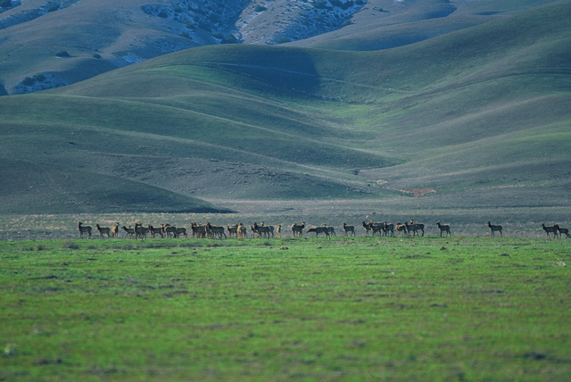
The Caliente Access Trail vanished after about 1.5 miles. Route finding wasn’t an issue, though — there’s no denying the roughness of the Caliente Mountains. I located a route that led to the ridgeline, and by sunset I chased shadows creeping across the stunning Carrizo Plain to the Temblor Mountains.
They were my reward following four days in the wilderness. A huge herd of tule elk enjoyed feeding on the Carrizo Plain, new growth grasses fueling an expanding herd of herbivores that roamed the eastside of the snow-covered Calientes. It was time to drop my pack and simply watch.


