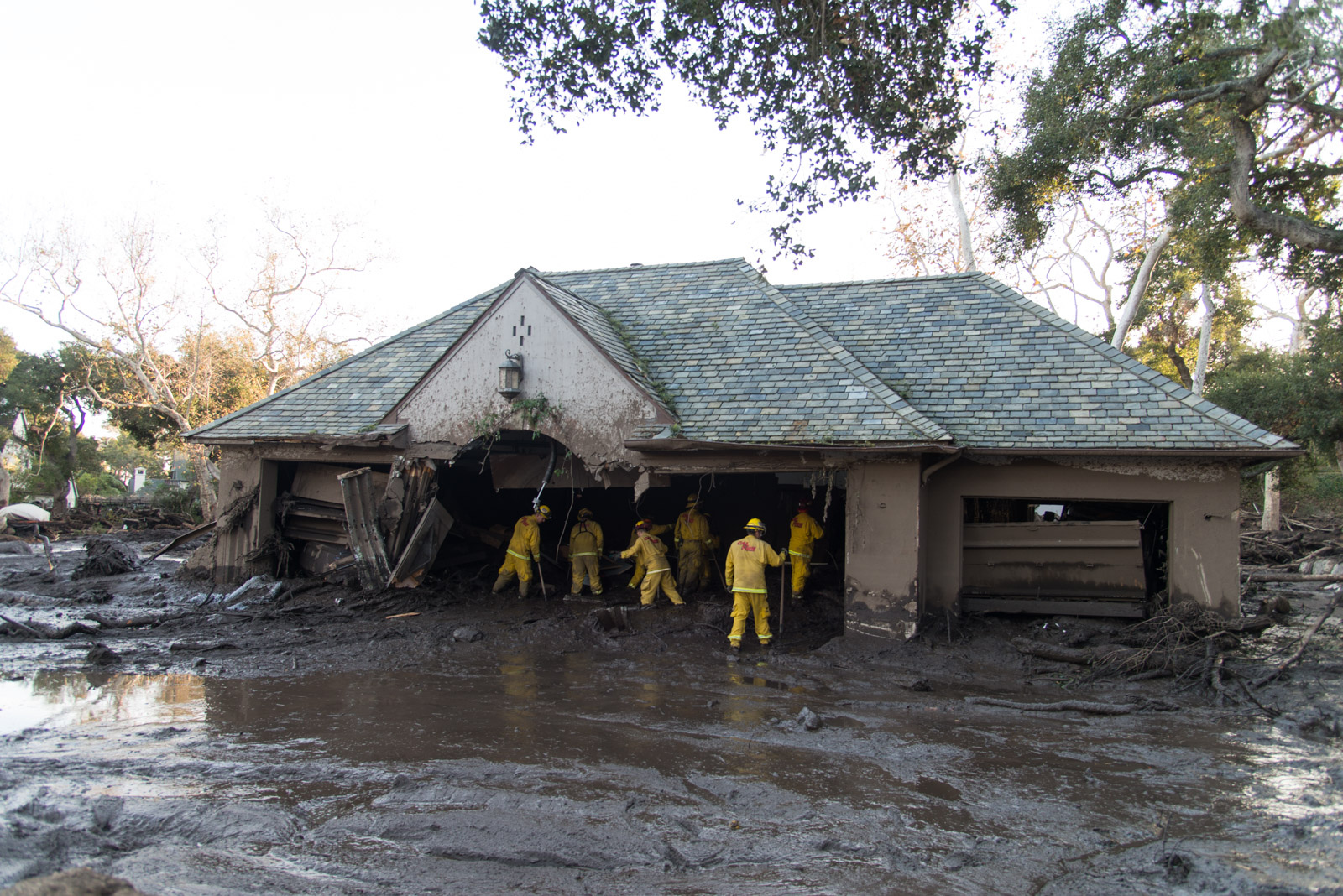
The surging river of mud and boulders that engulfed swaths of Montecito from the mountains to the sea last week, killing 20, was a rare disaster – so rare, geologists say, that it may happen only once in a few hundred to a thousand years at that location.
But that doesn’t mean it couldn’t happen again this winter, said Ed Keller, a professor of earth science at UC – Santa Barbara. All of the communities below the scorched slopes of the Thomas Fire are at risk, he said.
“These areas are very vulnerable in the next two years to debris flows,” Keller said. “We could get another one right down Montecito Creek this year, if we get another big rainfall, depending on how much debris is left up in the basin. It’s not impossible.”

The catastrophic debris flow of January 9 in Montecito is the deadliest disaster to hit the South Coast since a magnitude 6.8 earthquake struck Santa Barbara on the morning of June 29, 1925, leveling the downtown and killing 13.
Debris flows launch massive quantities of rocks, boulders, trees, and mud downhill. They are typically triggered after wildfires on steep mountainsides, when heavy rains wash away the soil.
“Big debris flows are relatively rare,” said Keller, who is applying for national funding to study the footprint and volume of the January 9 event. “They don’t occur after every fire in any one stream. The Thomas Fire was huge, and there are only a couple of places with really damaging debris flows. Montecito and San Ysidro creeks were primed for one.”
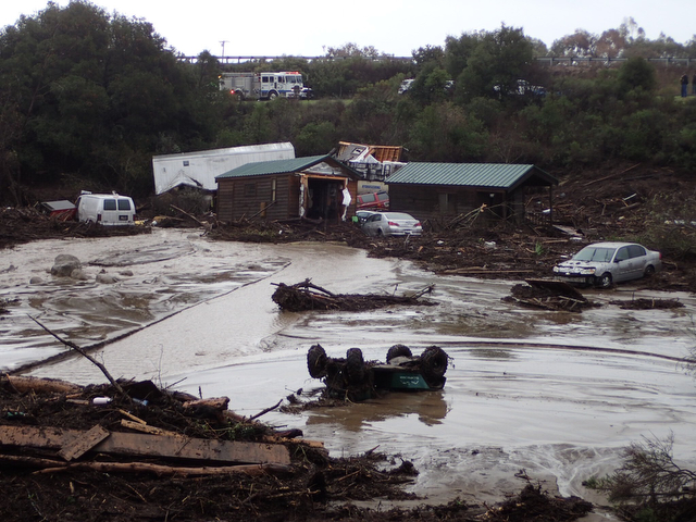
In catastrophic debris flows such as the one in Montecito, narrow canyons chock full of boulders start to flood and landslides may occur. Rocks and brush form temporary dams, then break through and roar downhill on thick slurries of mud. Car-sized boulders bob along like corks.
In Montecito, the wall of mud and debris was 15 feet high in some locations.
“You may get pulses of flows rushing out of canyons in the mountains,” said Larry Gurrola, a Ventura-based consulting geologist who is on Keller’s research team. “That material reaches the base of the foothills, chokes the streams, flows out over the banks and moves towards the ocean, dragging trees, brush, cars, utility poles and parts of homes along with it.”
Through the millennia, debris flows have shaped the terrain of the South Coast. Almost all of Montecito and most of Santa Barbara is built on top of flows that occurred here over the past 125,000 years, Keller said: just look at the boulder field at Rocky Nook Park. That’s evidence of a catastrophic flow out of Rattlesnake Canyon in prehistoric times, he said.
During the past 50 years, the South Coast has seen a few destructive but not catastrophic debris flows. Just last January, during heavy rain following the Sherpa Fire of June, 2016 in the mountains along the Gaviota Coast, a debris flow washed 22 vehicles and five cabins down El Capitan Creek and sent boulders into the surf. Emergency crews rescued two dozen campers.
This January 3, county emergency preparedness officials showed the Board of Supervisors photos of damage from the debris flows that followed the Coyote and Romero fires of 1964 and 1971, respectively. Both years, San Ysidro, Olive Mill, and Coast Village roads in Montecito were choked with mud.
This year, the stage was set for catastrophe after the Thomas Fire burned 440 square miles in December and January, largely in the backcountry of Ventura and Santa Barbara counties, becoming the largest fire in California history. It scorched the chaparral that anchors the soil to the bedrock and created a “hydrophobic” layer in the ground – a kind of crust that repels water like glass.
In an era of year-round fire seasons, the Thomas Fire had not been fully contained when the rainy season got underway in earnest.
“It was just kind of the perfect storm, when all the bad factors line up together,” said Jon Frye, Santa Barbara County engineering manager. “There was no time whatsoever between the fire and the winter.”
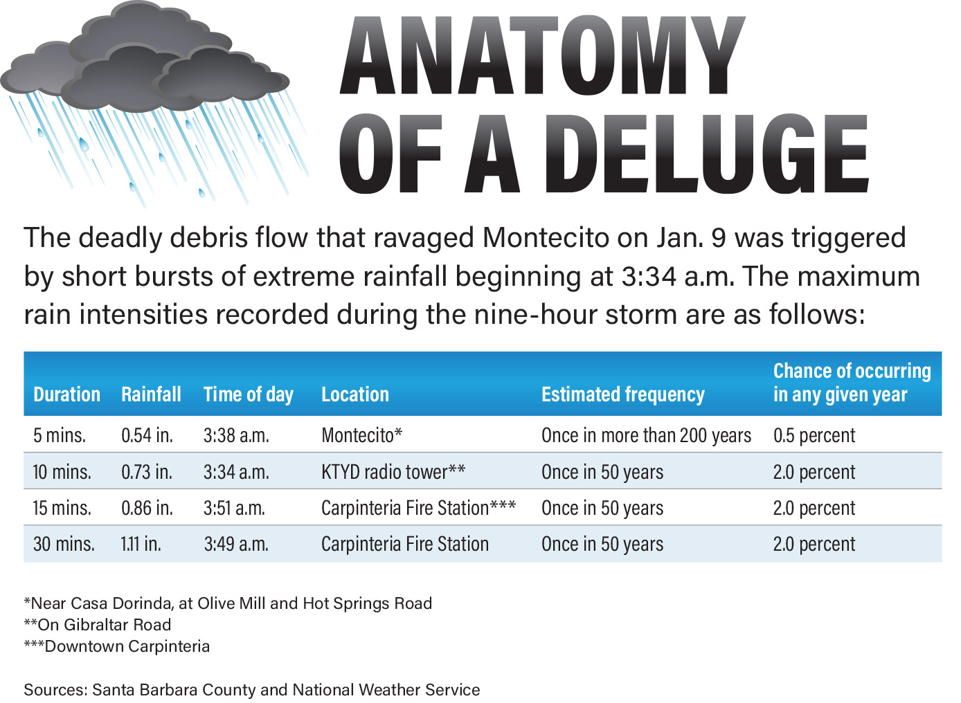
The trigger for the catastrophic debris flow in Montecito, geologists say, was several bursts of extreme rainfall, beginning at 3:34 a.m. One of these was a 200-year event – more than half an inch of rain falling in 5 minutes. That’s a quarter of the total amount of rain, 2.1 inches, that was recorded in Montecito during the nine-hour storm.
A U.S. Geological Survey (USGS) debris flow hazard map that was widely circulated before the January 9 storm showed the high probability of debris flows originating in the mountains above Mountain Drive in Montecito on the heels of the Thomas Fire. The slopes there are on a “hair trigger,” said Dennis Staley, a USGS research geologist who helped prepare the map. The harder the rainfall, the bigger the flow, he said.
“We knew that if it rained very hard, there could be very significant debris flows,” Staley said. “If you plug in the intensities that were received, our prediction aligns with what we saw.”
In any given year, there is only a half-percent chance that half an inch of rain will fall on Montecito in five minutes, said Jayme Laber, a senior hydrologist with the National Weather Service in Oxnard.
“It was a typical winter storm, but five-minute rainfall was extreme, something that you don’t see very often,” he said.
The 5-minute, half-inch downpour began at 3:38 a.m. near Casa Dorinda, at Olive Mill and Hot Spring roads, county records show. Between 3:34 a.m. and 3:51 a.m., three additional bursts of extreme rainfall – 50-year events with a 2 percent chance of occurring in any given year – were recorded on gauges near Gibraltar Peak and in downtown Carpinteria.
These were the heaviest short-term, high-intensity rainfalls recorded during the entire storm from Redding to San Diego, Laber said.
“It was horrible that it was right on top of the Thomas Fire burn area,” he said.
The first reports of the debris flow came in to the Weather Service shortly before 4 a.m.
Meanwhile, there was no major damage in Ventura County during the Jan. 9 storm. Ventura County took the brunt of the Thomas Fire, but was not pounded on Jan. 9 with the short-term, high-intensity deluge that overwhelmed Montecito, Laber said.
The historical record shows that previous debris flows on the South Coast closed Highway 101 and caused a lot of damage to property but did not kill anyone.
In 1964, a few months after the Coyote Fire burned 100 square miles above Santa Barbara, Montecito, Summerland, and Carpinteria, records show, a debris flow destroyed 12 homes and six bridges on Mission Creek in Santa Barbara. Eyewitness accounts told of “20-foot walls of water, mud, boulders, and trees moving down the channels at approximately 15 miles per hour.”
During heavy rains following the 1971 Romero Fire, which burned 20 square miles in the mountains behind Santa Barbara, Montecito, Summerland, and Carpinteria, Highway 101 was blocked for eight hours near Carpinteria. A wall of mud and water three feet high pushed across the freeway toward the ocean.
“Looking back, there is clear evidence that this type of thing happens in Santa Barbara with some regularity,” Staley, the USGS geologist, said.