
Sundowners. It’s a word that strikes fear in the hearts of all Santa Barbarans, especially on those warm summer nights when the light fades and dry air starts rolling down the mountains.
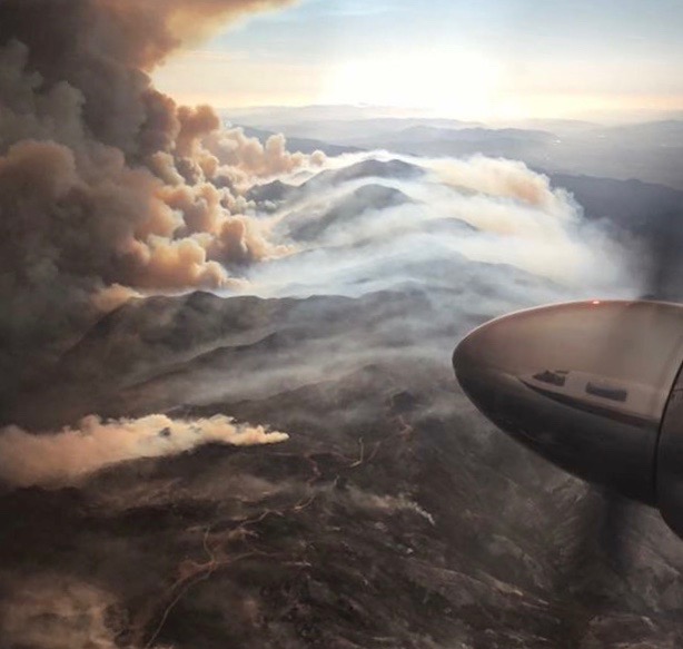
The South Coast–specific weather event has triggered nearly all of the region’s major wildfires, including the recent Sherpa, Whittier, and devastating Thomas, yet there’s been surprisingly little research done on the atmospheric dynamics that create such tinderbox conditions.
That’s about to change with a major $2.5 million grant given by the National Science Foundation (NSF) to a team of researchers from nine institutions headed by UCSB professors Leila Carvalho and Charles Jones. Their project — called the Sundowner Winds Experiment, or SWEX — will investigate how, why, and when sundowners form, which will in turn help forecasters and firefighters better protect the public during future fires.
Sundowners are a strange animal, explained Carvalho. While the better-known Santa Ana winds — which blow over the rest of coastal Southern California, from Ventura to the Baja border — typically kick up during the day from late fall through early spring, sundowners can strike any time of the year and tend to gather steam at night before losing their energy at daybreak. They hug the coastal slopes of the Santa Ynez Mountains, getting drier and heating up as they descend. They can shoot through the gaps, like the San Marcos Pass, but can also vary dramatically from one end of the range to the other. For example, Carvalho said, just this Monday, sundowners were blowing down the west end while the air in the east was still.
Carvalho, a meteorologist in UCSB’s Department of Geography and its Earth Research Institute, said it’s pretty well understood that the South Coast’s marine layer, Santa Ynez Valley weather, the valley’s physical shape, and the position of the San Rafael Mountains all play major roles in sundowner formation. But exactly how these factors interact is a mystery SWEX will help solve, she said. The study will take place next year from April 1 to May 15.
Carvalho said the grant will fund 15 temporary weather towers, a handful of LIDAR (Light Detection and Ranging, laser-based radar) systems, a truck traveling back and forth along Highway 101 getting measurements from the ground, and a research plane from Wyoming named King Air taking readings from above. King Air will also drop radiosondes, instruments carried by balloon that measure wind velocity, temperature, and humidity.
It took Carvalho three years of writing proposals and cajoling NSF officials to get the funding. Such big grants are extremely competitive, she said. Carvalho is excited to add to the scientific community’s understanding of unique weather events, but the work is personal, too. As a Santa Barbara–area resident who’s seen the devastation of fires up close, and felt the panic and heartbreak of friends who suffered close calls and lost homes, she wants to see the data help her hometown. Better information means faster, more accurate fire warnings for residents and safer planning for the firefighters in helicopters and planes who fly straight into the sundowners themselves.
The National Weather Service, the U.S. Forest Service, and the Santa Barbara County Fire Department are all helping with the study, Carvalho said. They’ve offered free rides through the mountains and access to their equipment. “Without them, this experiment would probably not happen,” she said.


