
Conflating the DIY (do-it-yourself) ethos and the Scouts’ motto to “be prepared,” the county released a new Cave Fire map to prepare residents as a rainstorm approached the Santa Barbara coast on Tuesday night. “The weather is always unpredictable, we tell people,” said county spokesperson Gina DePinto with a rueful laugh. “We thought Point Conception would shield us and the storm would blow away.” But as the clouds switched course and headed for Santa Barbara, a number of county departments and Los Padres National Forest officials gathered at the Office of Emergency Management to hammer out the map, De Pinto said, with input from the National Weather Service.
People have been asking for a map like this, she explained, as residents are very knowledgeable about debris flows and flooding since the Thomas Fire aftermath. And, after all, Santa Barbara is entering its rainy season. The interactive map enables residents to type in their address to learn if they are in an area that could be affected by flooding or debris from the Cave Fire watershed above them.
The amount of rain coming Tuesday night would not top flood or debris flow thresholds, DePinto said. Mark Jackson with the National Weather Service (NWS) called it a “well-behaved storm” that dropped relatively good amounts of water — 1.47 inches fell at the Goleta yard — but not in a deluge that would overtop the flood basins below the Cave Fire footprint.
His agency sent out a flash flood watch at 4 a.m., however, to areas below the Cave, Maria, and Easy fires, a broad swath that was warned of flooding potential. “The forecast for Santa Barbara County was a peak rainfall over an hour of one-third to two-thirds of an inch of rain,” Jackson said. “That might get a little soil moving, but not walls of mud.” The debris flow threshold for the NWS is 0.7 inches per hour. The flood watch ended at noon Wednesday.
The terminology for flash floods, Jackson explained, was that a “watch” means a flash flood was possible but not imminent or occurring. With harder rain, the NWS sends an “alert,” Jackson said, and to a much more narrowly targeted area. Should drivers at creek crossings get such an alert, he warned, “Turn around. Don’t drown,” a slogan often heard in deserts where flash flooding can be a deadly occurrence. In homes, people should head for the highest areas possible.
As after the Thomas Fire, Burn Area Emergency Response (BAER) and Watershed Emergency Response Team (WERT) personnel are traversing the Cave Fire burn scar for a better idea of the extent of the burn and which areas might be most vulnerable to heavy rain. They were hoping to give a preliminary report by the end of the week, DePinto said.
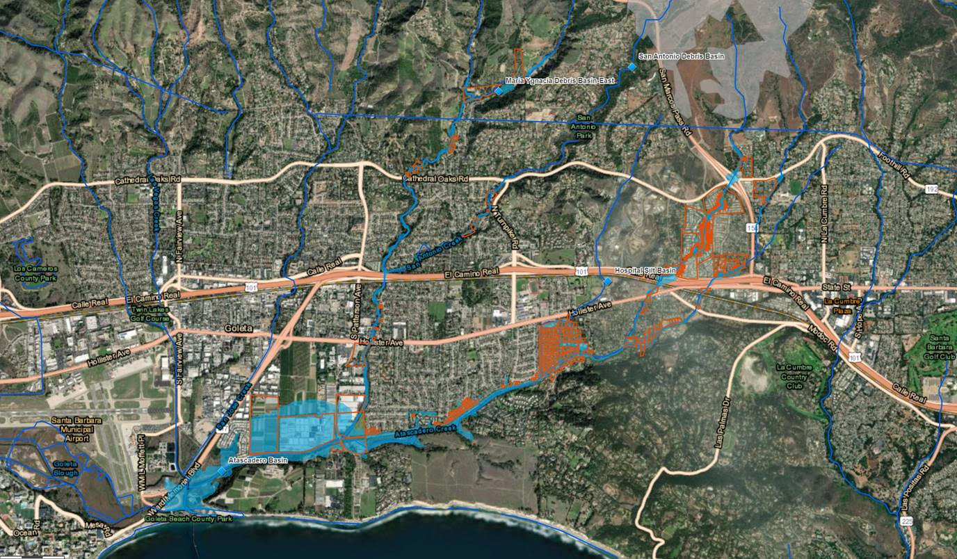
The new Cave Fire flood map shows a grey fire footprint and, in blue, the creeks as they course down the mountainside. The orange areas are “potentially impacted parcels,” according to the map’s legend, and large blue overlays show flood zones per Federal Emergency Management Agency mapping. The FEMA-mapped areas show 500-year flood zones, or areas with a 0.2 percent chance of flooding, explained Jon Frye with County Flood Control. It’s something of a roll of the dice, he acknowledged, and only reflects historic flood water data, not debris flows.
From there, said DePinto, residents should examine their location, determine whether they’re at risk of flood from the Cave Fire drainage, and consider how they’d evacuate if an emergency alert is sent. The next step is to prepare for a quick evacuation. Tips and strategies can be found at County Fire’s Ready Set Go program page. After that, it’s “situational awareness,” said DePinto, or staying abreast of weather conditions. Links to National Weather Service reports are at readysbc.org, she said, and the county’s 2-1-1 information line can also provide up-to-date information.
What was very important for people to know, DePinto emphasized, is that if they felt threatened but hadn’t received a warning, they should evacuate anyway. “We find that people wait to be told to leave,” she said. “You should never sit and wait. And when you get an alert that says, ‘Hey, something is happening,’ you should already be ready to go.”


