
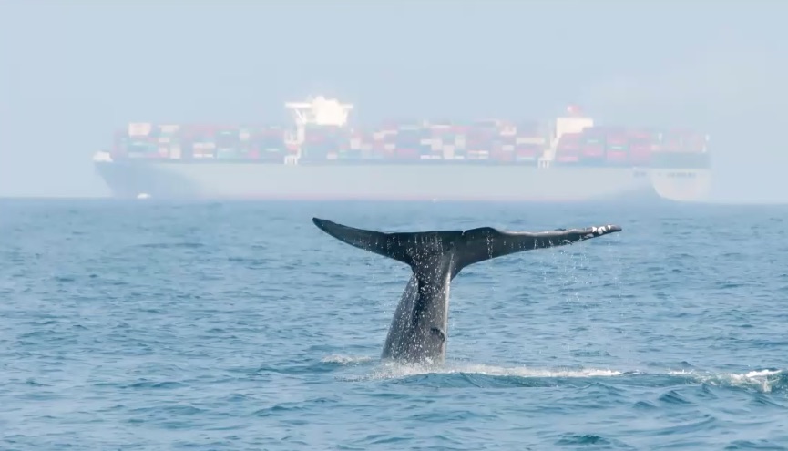
It’s tough to imagine an unarmed human making so much as a dent on a blue whale. As the largest animals in Earth’s history, these giants can grow to over 100 feet long and weigh up to 200 tons, with hearts the size of a car and tongues as heavy as an elephant. Put the human behind the wheel of a shipping vessel, however — many of which measure a thousand feet long and well over 300 tons — and a more gruesome story unfolds. Whales have gotten pummeled, literally and fatally, by shipping traffic as it has increased over time.
A team of scientists and oceanographers from around the country thinks it has a solution: Whale Safe, an online tool providing near-real-time data to detect endangered whales — chiefly blue whales, fin whales, and humpbacks — to anyone who wants it. And it’s debuting right here, in the Santa Barbara Channel.
“We received several requests … specifically regarding whale-ship collisions,” said Morgan Visalli at a recent press briefing, describing the public input that helped catalyze the development of Whale Safe three years ago. Visalli is a project scientist at Benioff Ocean Initiative, the UCSB-based collaboration of universities and oceanographic institutes that created the tool.
The need to protect whales from collisions with shipping vessels, she said, has long been apparent. Global marine shipping traffic has increased by 1,600 percent in the past 40 years, and whales following krill, their primary food source, into high-traffic areas frequently get struck and killed by massive boats moving at up to 25 knots (about 29 miles per hour).

Get the top stories in your inbox by signing up for our daily newsletter, Indy Today.
Calculating the exact death toll from collisions is difficult — mariners often don’t notice whale strikes, and most whale carcasses sink or wash offshore before they can be autopsied — but Visalli cited a 2017 study estimating at least 80 endangered whale deaths from collisions off the West Coast every year. For an animal as slow to reproduce as the endangered blue whale, that’s enough to push localized populations toward collapse.
The Benioff initiative has responded with Whale Safe. After three years of development, guided by input from scientists and shipping industry stakeholders, the team chose the Santa Barbara Channel as the launch point. Besides sitting close to Benioff’s base at UCSB, the channel provides a perfect testing ground: It’s both a hotspot of whale activity and a major shipping route for boats entering and leaving the ports of Los Angeles and Long Beach — the busiest ports in the Western Hemisphere, through which thousands of vessels pass each year.

The tool seeks to improve mariners’ awareness of whale presence by drawing from three major data sources. The first compares the locations of 100 satellite-tagged blue whales against three-dimensional data of ocean conditions in near-real-time, creating a model in which ocean conditions can predict the presence of blue whales in any given location. “We can think of this like a weather forecasting system that gives us a clue for what’s coming,” said Dr. Briana Abrahms, who led the modeling project. “Like the daily weather forecast, it doesn’t tell us if it’s raining right now, but it puts us on alert and it lets us plan ahead to bring a jacket.”
In addition, an underwater system of microphones record whale songs, allowing Benioff scientists to tell which species are present, while whale sightings reported by citizen scientists — chiefly through whale-watching tourism and the Whale Alert app — provide specific data points as a supplement to the model.
The end result is an interactive map of the south coast, with a color gradient showing the likelihood of whale presence and markers indicating whale sightings. Clicking a specific spot gives a whale presence rating, Visalli explained, “kind of similar to the Smokey the Bear fire-risk rating that gives you a low-to-high assessment of the possibility of fire today.”
Whale Safe rates more than whale presence, though: It also ranks shipping companies by their sensitivity to marine life. The U.S. Coast Guard and the National Oceanic and Atmospheric Administration advise vessels over 300 tons in the Santa Barbara Channel to move at 10 knots or slower — about 11 miles per hour — to reduce the frequency and fatality of whale strikes. Using data from vessels’ automatic identification systems, Whale Safe has identified which ships and companies tend to ignore that request and has publicly ranked them based on their behavior.
This public rating may well boost Whale Safe’s ultimate effectiveness. “We’ve actually begun some initial conversations with different retailers that use these shipping companies and take sustainability really important[ly],” Visalli said. Sharing that information, she hopes, may influence their choices about their supply chains. This would put pressure on shipping companies, who could use Whale Safe to know when to avoid certain areas or keep below 10 knots. In the long term, Visalli hopes, “maybe one day we’ll be able to have whale-safe products in the same way that we have dolphin-safe tuna, so we can connect this issue all the way down to the consumer.”

Benioff director Dr. Doug McCauley closed the press briefing by characterizing Whale Safe as a triple win. Reducing whale deaths is a win in itself, he explained, but doing so also helps mitigate climate change: Whales’ diving movements push nutrients to the ocean’s surface, feeding phytoplankton and marine plants that absorb carbon dioxide from the atmosphere as they photosynthesize. Nutrients in their excrement provide a similar effect. Slowing ships down, meanwhile, reduces not only their carbon emissions but their emissions of air pollutants like nitrogen oxides — thus making a win for public health as well.
Whale Safe may also constitute a win for the shipping industry, which now has a tool to reduce its impact without the burden of government regulation. “I think that mariners would agree that even one or two dead whales is too many. Nobody wants to hit or kill a whale,” said Visalli. “And they especially don’t want to come into port with a whale wrapped over the bow of a ship.”
Benioff Ocean Initiative will hold a public information webinar on Whale Safe on Friday, October 2 at 11 a.m. PST. RSVP by emailing boi-whalesafe@ucsb.edu.


You must be logged in to post a comment.