
[Update: January 5, 2023] All evacuation orders have been lifted for the Thomas, Alisal, and Cave fire burn areas in Santa Barbara County as of 9:30 a.m. Thursday, following the major storm that began Wednesday evening. For the latest story, click here.
[Original Story] A major storm sweeping through Santa Barbara County late Wednesday night through Thursday has county officials cautioning residents to understand the seriousness of the situation, take necessary safety measures, and follow mandatory evacuation orders, effective immediately for the entire Alisal Fire burn scar area and vulnerable sections of the Thomas and Cave Fire burn scar areas.
Recent burn scar areas in South County, primarily along waterways in Carpinteria, Summerland, and Montecito, are expected to be most affected by the storm, as well as parcels within the Alisal burn scar area along Refugio Canyon and the Gaviota Coast. The largest number of parcels of land to be evacuated are in the Thomas Fire burn scar area, followed by the Alisal burn scar area, and then the Cave Fire burn scar area.
The number of residences to be evacuated is in the hundreds, according to Kelsey Gerckens Buttitta, public information officer of the County Executive Office. An interactive evacuation map has been made available for residents in and around recent burn scar areas, and residents are encouraged to plug their address into the map to find out whether they are in an evacuation zone. Alerts will also be sent out to county residents through a wireless alert system, and sheriff’s deputies and sheriff’s search and rescue team members will be going door to door and patrolling in the areas where the evacuation orders have been issued.
County officials say that residents with any questions about what is happening should not call 9-1-1 unless they have an actual emergency. Instead, they can receive information by calling 2-1-1 or the Office of Emergency Management Call Center at (833) 688-5551. People can also receive information and instructions online and sign up for emergency notifications at readysbc.org.
South County residents needing to evacuate their homes can take shelter at the Wake Center (300 N. Turnpike Rd., Santa Barbara). See ReadySBC.org for evacuation center hours. Large animals can be sheltered at Earl Warren Showgrounds. For the latest animal evacuation information, call Santa Barbara County Animal Services at (805) 681-4332.
Expected across the county is an estimated four to eight inches of heavy rain, with some isolated regions of the county anticipated to reach 10 inches of rain, officials announced Wednesday. Strong winds of up to 50 to 60 miles per hour throughout the county and high surf are also expected. The National Weather Service has issued a Flash Flood Watch for Santa Barbara County from Wednesday late afternoon through Thursday morning, and warns flooding caused by excessive rainfall is possible within the entire watch area.
The most significant rain is expected to occur between 10 p.m. Wednesday and 5 a.m. Thursday, with the most intense period of rain likely occurring between midnight and 3 a.m.
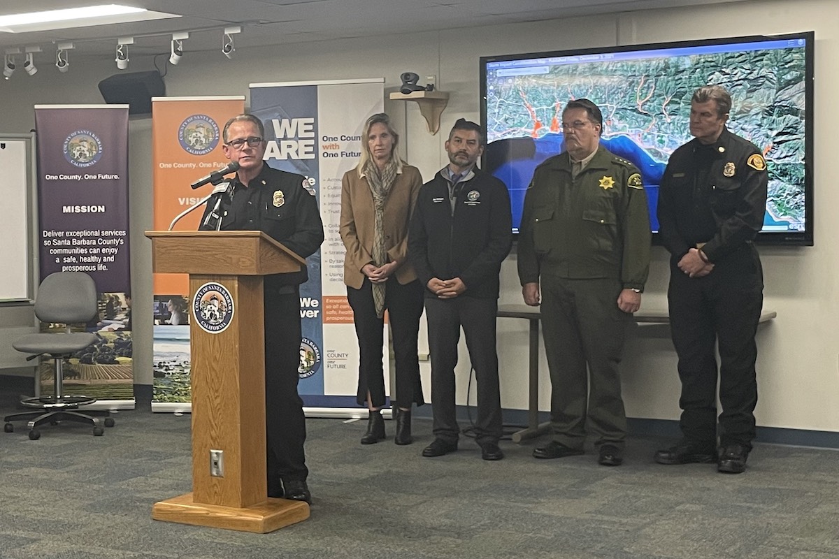
“With the saturation of the soil, the potential for trees coming down and the potential for increased rainfall in the Foothill communities is of major concern,” Santa Barbara County Sheriff Bill Brown warned at an emergency press conference Wednesday.
Ground saturation is of concern following the 8-13 inches of rain the county has received in the past 30 days, with the county watershed already in a saturated condition. Brown said residents should “please use caution” around trees and electrical poles Wednesday evening through Thursday morning.
Santa Barbara County public fire rescue and EMS providers are trained to work together “to assist each other not just in fires but, as we’re dealing with today, in potential floods and debris flows,” said Chief Mark Hartwig of the County Fire Department on Wednesday.
Sign up for Indy Today to receive fresh news from Independent.com, in your inbox, every morning.
Sixty responders, including fire engines, patrols, and rescue squads, will be stationed throughout the affected areas Wednesday evening with emergency vehicles and equipment ready to deal with situations such as those involving fallen trees and electrical lines.
“We’re prepared to deal with whatever happens,” Hartwig said. “We hope those resources aren’t needed. But we’ll be here if you need us.”
Montecito Fire Chief Kevin Taylor said this storm setup “looks very similar to what occurred in our community in 1969, five years following the 1964 Coyote Fire.”
“For those of you not aware of that history, the ’69 storm triggered debris flows and debris-laden floods in every watershed facing the Santa Barbara Channel in our community,” Taylor said. “There was significant damage and fatalities as a result.
“It was the result of a saturation event,” Taylor continued, adding that the National Weather Service defines a saturation event as 8-10 inches of rain in 24 to 48 hours. “We’re going to see that with this storm; therefore, we believe we’re at a saturation event. The areas at risk are very clearly identified as those red areas on the storm impact consideration map that was developed by a professional engineering firm that actually used modeling to evaluate our debris flow risk given the current status of the watershed.”
Taylor also acknowledged that Monday, January 9, is the five-year anniversary of the catastrophic 1/9 Debris Flow, also known as the Montecito Mudslides, which took the lives of 23 people in 2018. “While this storm is forecast to be less significant than what occurred on 1/9, it is still powerful and should be taken very seriously,” he said.
Supervisor Das Williams said his comments at the Wednesday press conference were aimed toward those being asked to evacuate. “I know, because I’ve been through the last five years with you, how dismaying this is,” Williams said. “A lot of people wanted to feel like this part of their life was over. But we live in this beautiful place. And there are some consequences of living in this beautiful place. And that is that we have this risk.”
“I am urging folks to comply with the evacuation if you live in that red zone,” Williams added. “The one thing we should have learned these past five years is it is better to play it safe and to evacuate, and to comply with the order. I know it’s hard to hear it. It’s a hassle. It’s dismaying, but it’s better to play it safe for your family, for your loved ones, for the future of the community.”
California Highway Patrol Captain Mike Logan said the CHP will be working proactively with Caltrans to ensure that the roadways remain open, and should roadways become closed due to events such as rock slide or flooding, they “will get that message out immediately.” The CHP will be working jointly with sheriff’s deputies to ensure residents’ safety, but Logan advised that people should not travel or use roadways “unless absolutely necessary,” and should “drive alert” and “slow down.”
In addition, Sheriff Brown said, “the sheriff’s deputies will be conducting high-visibility patrols of [evacuation areas] to discourage any criminal activity that some would exercise to take advantage of,” and deputies will be “vigilant in looking after those properties.”
Kelly Gordon, Santa Barbara Chief of Police, in response to concern about boats anchored in the harbor, said “Harbor Patrol is making every effort to make sure that all the boats are brought into the safe harbor area … Efforts are currently ongoing to make sure that none of those in the free marine area are left out there, and we also have the ability to respond if we do end up with those vessels on the beach.” High winds early Wednesday morning were strong enough to drag abandoned sailboat Norma Zane‘s anchor and fling her onto Santa Barbara’s East Beach.
Support the Santa Barbara Independent through a long-term or a single contribution.


