

TRAIL INFORMATION
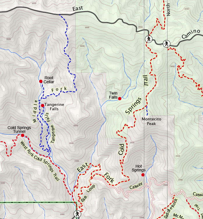
Distance-0.75 miles to the pools; 1.5 miles to the loop trail; 1.75 to the Montecito Overlook; 3.5 to Montecito Peak; 4.5 to Camino Cielo.
Elevation Gain-350 feet to pools; 1,100 feet to powerlines; 2,450 feet to top of Montecito Peak; 2,775 feet to the crest.
Difficulty-Moderate to very strenuous depending on the distance
Topo-Santa Barbara
HIGHLIGHTS
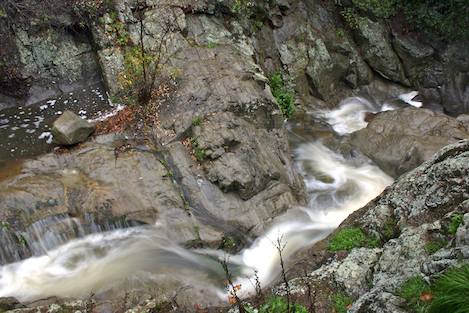
This is absolutely my very favorite trail. Within a few yards of your car the pools begin. Deep and shaded by alders, the perennial creek offers scores of places to spend an afternoon. Even the name suggests something special. Cold Springs represents the shortest distance you can travel to get the furthest away from Santa Barbara. Above the trailhead you will find bedrock pools and places to sunbathe, overlooks of the coastline and a route to the mountain crest, the one memorialized by Stewart Edward White in his epic book, The Mountains. Though no trail leads up into it, you’ll find a beautiful waterfall hidden deep in the watershed.
TRAIL CONDITIONS
The East Fork Trail has undergone extensive trail work in the past year. Under a flood grant obtained from the Forest Service, the Los Padres Forest Association Trail Crew completely rebuilt the trail from Mountain Drive up to the power lines, adding lots of erosion control, walls to make trail use safer for all users, and tread work in places to widen the trail and eliminate obstructions. While the trail is now much safer, due to its steep side slopes in the canyon section, there are still plenty of danger spots, especially for those on mountain bikes or horses. Please use the trail with care and be aware that hundreds of users are on the trail every week.
DIRECTIONS
Because Sycamore Canyon Road is currently closed to through traffic, Hot Springs Road in Montecito is the easiest route to the trailhead. From Highway 101, take the Hot Springs exit and follow this toward the mountains until you reach the Highway 192/Foothill Road. Turn left and follow this for a mile to Cold Spring Road. Turn right and continue up to Mountain Drive. Park near the point where the creek crosses the road.
SETTING THE SCENE
Cold Springs Trail was one of the first trails I hiked many years ago and it is still my favorite. This is a creek that drops sharply through Coldwater and Matilija sandstones, with clear springs originating high above the trailhead, accessible only by an arduous (but thrilling) hike past the trail’s end. Gushing forth from the shaley depths of the Juncal Formation, the creek runs cool and crisp year-round, flowing freely even on the hottest August day.
The canyon beauty begins at the road’s edge. Alders thickly covered with green leaves flutter in the breeze. Twenty yards upstream are the first pools. Even if you only have an hour, this is a place where you can enjoy a few precious minutes of quiet. With the canyon walls and alder boughs for privacy, sandstone boulders for resting spots, and the creek’s incessant babble for companionship, you’ll fall in love with it, too.
THE HIKE
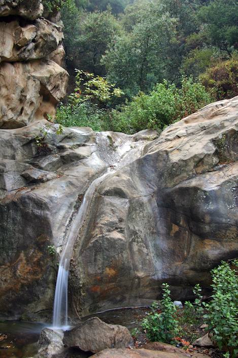
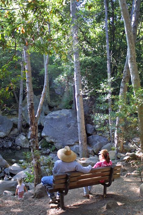
From the parking area the path follows the east side of the stream, gradually rising through a forest of live oak before returning back to the creek and a profusion of alders. A very beautiful twin-spouted waterfall and bench from which to enjoy it can be spotted near the side of the creek. In a thin opening, easily missed, you’ll find the turnoff to the West Fork trail.
Beyond here the East Fork trail heads away from the creek, switching back and forth several times to a point where there is a nice view of West Fork canyon. From there the trail is level. It is also is narrow and a bit dangerous unless you are careful; the mountainside falls away rather precipitously. After a half mile the trail rejoins the creek at a lovely grouping of alders, a small waterfall, and a pool.
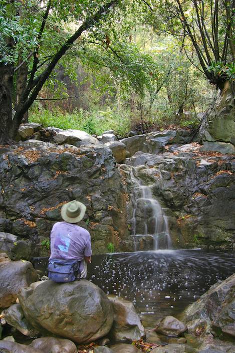
The trail then crosses the stream, heads left up into chaparral, then switches back to the right, bringing you to a bedrock canyon where there are a number of waterfalls and pools. The open sandstone ledges and sunning spots are very popular for afternoon lunches.
This also marks the end of the canyon section of the East Fork. A hundred yards beyond, the trail turns right, crosses the creek, and rises up a strike canyon into the chaparral. Continue up the creek if you like. Though it rises rather steeply, the hike up canyon is worthwhile. Many surprises await you if you have the energy to travel far enough. Even if you don’t get too far there are plenty of places to stop and have a place all to yourself.
The main trail follows the side canyon, which was formed by the weathering of the easily eroded Cozy Dell Shale. The path curves in a clockwise direction around the canyon then begins to switch back and forth up to a viewpoint where there are several power-line towers and very nice vistas. The dirt road built to service these towers leads into Hot Springs Canyon and eventually over to San Ysidro Canyon.
Just before the last switchback leading up to the towers you’ll notice a trail intersection. This marks the start of the Ridge Trail. You can loop back down this to Mountain Drive. This trail is actually a remnant of the original Forest Service trail which was built nearly 100 years ago when the Cold Springs Trail was rerouted from the Middle Fork here to the East Fork. Ironically, this trail was then abandoned in favor of the present-day route.
Thanks to several local residents, who believed the historic route should be re-opened, it is now possible to follow the Ridge route back down, creating a great loop hike. The trail isn’t quite as well developed as the main trail but it is very serviceable. Quickly you will find yourself surrounded with spectacular views out toward the coastline and up into the West Fork canyon. These continue all the way down to Mountain Drive.
TO THE CREST
If your intent is to continue toward the crest you will reach the power lines about a quarter mile beyond the loop intersection. Follow the dirt road 50 yards east and you’ll spot the start of the upper section of the Cold Springs Trail on the left. It rises quickly up into the Matilija Sandstone. The route curves around the east side of a large knoll, which you will appreciate very much if you are hiking up in the afternoon, because the knoll shades this section, which is steep.

As you round the final curve you’ll notice an intersection leading down into Hot Springs Canyon. There is a “No Trespassing” sign posted at the entrance and the trail hasn’t been maintained for quite awhile.
A mile further up, after a series of switchbacks, the solitary eucalyptus tree will tell you that Montecito Peak is not too far ahead. The trail crosses the western flank. If you want to hike to the top of the peak, continue on the trail until you are almost past it. The route leads very steeply up the north side of the 3,214-foot Montecito Peak. It is a 2,500-foot (a half mile!) climb from the trailhead to the top but what a feeling once you are there.
After this the trail continues upward along a ridgeline and then curves left into the upper end of Cold Spring Canyon. Gradually the steepness begins to lessen and the walking becomes easier as you enter the Juncal Formation. From there is it a half mile of much more pleasant walking to the crest.
From here you can continue on down the back side of the Santa Ynez Mountains, either to Forbush Flats or all the way to the river. Or you can turn right on Camino Cielo and walk east several hundred yards to the San Ysidro Trail and drop back down it.
Often, once I reach the road I head up off the trail and find a resting spot on top the cement water tank. Perhaps a more fitting way to say this is, I often head up to the top of the tank to collapse after the effort of getting here. These tanks have a very interesting design. Their wide tops are sloped gradually inward to an opening in their centers and are used to collect rain water for use during the fire seasons. For me they are great spots to kick back.
It is also a great place to reflect on the words that White authored 100 years ago: “It left you breathless, wonder-stricken, awed. You could do nothing but look, and look, and look again, tongue-tied by the impossibility of doing justice to what you felt. In a little … the change had come to you, a change definite and enduring, which left your inner processes forever different from what they had been.”
Perhaps you have felt these feelings. I know I have.


