
Santa Barbara County officials made great efforts to warn residents of the hazards to life and limb that could result from the predicted January 9 storm. They used exceptionally strong language for government employees — “significant threat,” “critical situation,” “clear and present danger” — to describe how the heavy rains that were forecast to pound the South Coast might trigger flash flooding and mudslides in the Thomas Fire burn scar. Emails, texts, and Facebook messages were sent. Phone calls were made. A press conference was organized.
In the end, only 15 percent of residents under mandatory evacuation orders actually left their homes, a startlingly low figure attributed alternately to Thomas Fire evacuation fatigue, a defiance of Mother Nature, or a more general misunderstanding of the awesome power of debris flows.
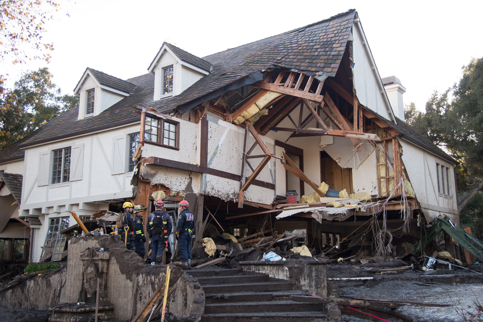
But as we learn more of the circumstances surrounding the deaths of the 21 people confirmed killed in one of the worst disasters in Santa Barbara history, the consistency and accuracy of the official warnings are coming under scrutiny. And as we discover mistakes in the information that authorities disseminated, questions are surfacing as to whether better decisions could have been made.
Robert Lewin, director of the county’s Office of Emergency Management (OEM), admitted this week that his department issued conflicting evacuation instructions at 7 p.m. on Sunday, January 7, approximately 30 hours before the storm hit. “Regrettably … I approved a press release and Facebook [post] that had discrepancies with the western boundary of our intended voluntary evacuation area,” he said in a prepared statement.
That press release described the voluntary boundaries as Highway 192 to the north, the ocean to the south, Olive Mill Road to the east, and Hot Springs Road to the west. News agencies reported the borders this way, and the Sheriff’s Office posted the same information on its website. However, a map published on the county’s own website included a larger voluntary evacuation zone that extended farther west to Summit Road.
The map was accurate, said Lewin; the written description was not. A correction was never issued, and county officials remained unaware of the discrepancy until this Sunday, when reporters inquired about the contradictory information.
Fifteen of the 21 Montecito residents who perished in the storm lived in this area — under voluntary evacuation orders, according to the map, but under no evacuation orders whatsoever, according to the county’s official written notification. Two more victims who are still missing and feared dead — 17-year-old Jack Cantin and 2-year-old Lydia Sutthithepa — also lived west of Hot Springs Road.
Two others lived in the voluntary area described in the January 7 press release. Only four fatalities had lived within the mandatory evacuation borders.
The east-west line of Highway 192, below the Thomas Fire burn scar, was used to divide Montecito into two distinct emergency notice regions: Mandatory evacuation orders were issued north of the boundary, and voluntary notices were made below the highway.
The 7,000 residents in the mandatory zone were told on January 7 to leave their homes immediately. Sheriff’s deputies went door-to-door the next day to repeat the order. The 23,000 people in the voluntary area were advised to pack their bags, load their cars, and be ready to flee at a moment’s notice. But by the time emergency alerts went out on the night of the storm, it was too late for many to escape the trains of mud and rock that came crashing through their neighborhoods.
The county had never before drawn a flood evacuation map for Montecito, and these evacuation zones were originally developed after the 2009 Jesusita Fire. The Sheriff’s Office, which is responsible for drawing and enforcing emergency-time boundaries, determined it needed a fast way to select easily identifiable areas and the intersections required to keep them closed. “The 192 is the only straight east-west arterial that there was,” said Sheriff Bill Brown in an earlier interview. “Everything else was a winding spaghetti of neighborhood streets.” As a result, the Montecito zones were not drawn to follow the downstream flow of creek channels.

In the same January 7 press release, however, Gaviota and Goleta residents living below the Whittier Fire burn scar, along creek channels and canyons, were given mandatory evacuation alerts. Tecolote, Eagle, Dos Pueblos, and Gato canyons were all in the mandatory zone. No voluntary warnings were issued.
Once again, there was a discrepancy between the written press release and the county’s official map for the Gaviota and Goleta area. This time, the wording was right and the map was wrong. Independent reporters alerted authorities to the error on the evening of January 7, and OEM officials corrected the map soon after.
While Gaviota and Goleta were spared the storm’s wrath, Montecito felt its full force. At a press conference this Sunday, January 21, Brown claimed that only six Montecito victims lived in the voluntary area, while 11 lived “right on the border,” as outlined on the January 9 map. Those 11 fatalities, however, had lived on the south side of the 192, which that same map clearly described as the voluntary zone.
The debris-flow devastation that ran downhill and blasted through the 192 was concentrated along Montecito, San Ysidro, and Romero creeks, with Montecito Creek hit hardest. The paths of destruction down to the ocean closely mirrored historical surveys of the same geological events and were nearly identical to FEMA’s current flood-zone charts, but the county did not use any of these to draft its evacuation map.
The north-south routes also followed the same drainage channels highlighted in another map presented by county flood-control managers during an earlier, January 5, press conference. Bold swatches of red (for the burn scar) and blue (for the flood routes) previewed the impacts of a 100- or 500-year storm. Thick blue lines stretched down from the mountains, then pooled together between Fernald Point and Butterfly Beach as hypothetical mudslides clogged bridges and overwhelmed catch basins, spilling debris into neighborhoods — the exact scenario that played out in the dreadful morning hours of January 9.
The flood map was published on January 5 on the county’s website. It allowed residents to enter their address and determine if they lived in a danger zone. But two days later, on January 7, the county’s OEM replaced that flood map with their evacuation map, which did not display predicted flood paths. Lewin said later he thought making both maps available would confuse residents.

In the days leading up to the storm, forecasters said the flood risk was 10 times greater than in a normal year. But they later said they could never have anticipated the record-breaking downpour or the massive size of the debris flows that followed. “The expectation was that rainfall of one inch per hour could kick something loose, but that it wouldn’t go very far,” said Kevin Cooper, a biologist with the U.S. Forest Service, who consulted on the evacuation map. “As slopes lessen, the debris drops out. For something to push all the way out to the ocean like it did, it had to be an extraordinary event.” By the end, Montecito received about 3.3 inches of rain. Of that, a half inch fell within five minutes. According to county records, it was a 200-year event.
Some of the victims were dragged more than a mile from their homes. Brown said recovery teams continue to comb the area for the remains of Cantin and Sutthithepa. “It’s very possible that they could be underneath a significant amount of mud that is drying and has to be removed,” he said. “It’s possible one or more of them could have been swept out to sea.”
In the days immediately following the disaster, Brown dismissed questions about the adequacy of the evacuation orders. He said trying to identify where in the evacuation zones victims lived and where the majority of the damage was concentrated was “splitting hairs” and a disservice to first responders, whose heroic efforts remain undisputed.
In the days before the storm arrived, Lewin continually stressed that all Montecito residents needed to take personal responsibility for their own safety. Sign up for the county’s alerts, he urged. Check the map. Make a plan. “But unfortunately, unlike in the fire, where we could merely say to evacuate ahead of time, sometimes evacuation isn’t the best choice,” he said during the January 5 press conference. “Sometimes the best thing for people to do is to go to their neighbor’s home that’s on high ground to get out of harm’s way. Sometimes the best action is to merely shelter in place.”
At 2:46 a.m. on the night of the storm, as the hills started to slide, OEM sent a flash-flood cell-phone alert to Montecito residents registered with the county’s digital emergency notification Aware & Prepare program, saying: “GO TO HIGH GROUND.”
Recipients have since complained the directive was unclear. While some interpreted it to mean run outside and head uphill, Eric Boldt, a National Weather Service warning coordination meteorologist in Oxnard, explained such messages in flash-flood situations actually mean stay put. “Go to the highest part of your house,” he said, “an attic or even a countertop.” It makes little sense to try and outrun a debris flow, he went on. “It’s better to evacuate before the storm starts.”
Records show that approximately 41,000 Santa Barbara County residents — or just above 10 percent of the total population — have opted into the Aware & Prepare program. Lewin couldn’t say how many of them lived in Montecito.


