
Nearly five months have passed since avalanches of rock and mud triggered by a ferocious winter storm ripped through Montecito and killed 23 people. For most, the 1/9 Debris Flow has faded from immediate memory, but for residents of the small seaside community, the tragedy remains etched in sharp relief across devastated neighborhoods and among brokenhearted families.
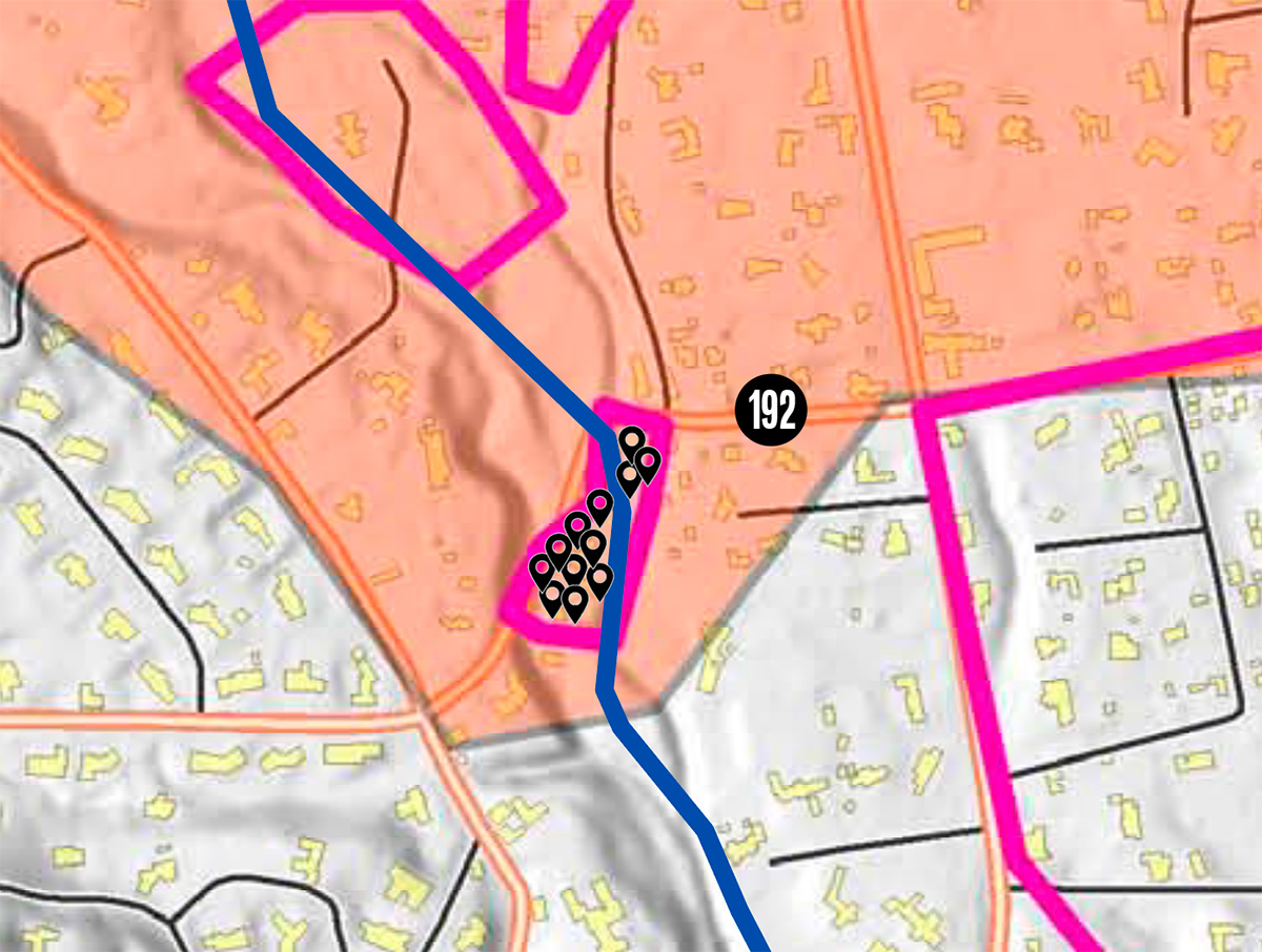
Since that terrible night, Santa Barbara County’s public-safety officials have stood firmly by the decisions they made to protect residents from disaster, arguing they did the best they could with the information they had as the clock ticked and the storm approached. Among survivors, however, deep concern remains about the adequacy of their public messaging and evacuation strategies. County managers chose to evacuate Montecito residents north of Highway 192 and issue only warnings south of the line. Nineteen victims died along creek channels south of the highway.
In an attempt to better understand the process by which officials made these decisions, the Santa Barbara Independent filed a California Public Records Act request with the County Executive Office. The paper asked for all reports and correspondence related to the creation of Montecito’s voluntary and mandatory evacuation zones ahead of the debris flow.
This story features the most illuminating information the county provided, mainly internal emails in the chronological order they were written. Interviews and analysis accompany some of the entries. While the messages answer many questions about what county officials were thinking and considering at the time, they also reveal a lingering mystery: why their evacuation tactics relied on an old grid system used during wildfires rather than a new, high-tech map that pinpointed areas of risk along Montecito’s waterways.
The great challenges that come with public communication in a time of crisis are highlighted, as well. It becomes clear that Santa Barbara authorities, already running on fumes after marathon management of the Thomas Fire through the holidays, worked diligently — and struggled mightily — to craft clear warning messages and then efficiently disseminate them. This challenge may help explain why so few chose to evacuate and why so many others became unwitting victims in Santa Barbara’s deadliest natural disaster.
Wednesday, December 27, 2:30 p.m. Rob Lewin, director of the Santa Barbara County Office of Emergency Management (OEM), emails Cal Fire and U.S. Forest Service officials about a topography-based “Thomas Fire Flood/Debris Flow Risk Areas” map his department is developing. “We have been working on an innovative GIS [geographic information system] method to identify evacuation areas in the debris and flood area,” Lewin writes. “Our intention is to surgically identify those residences that will be impacted and not alarm areas outside those areas.”
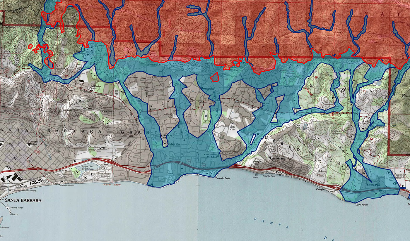
Monday, January 1, 6:43 p.m. Patrice Shepherd, a research specialist with the Riverside County Emergency Management Department contracted by Lewin to develop the interactive “Flood/Debris Flow Risk” map, emails him a final version of the map (see above). Its blue-shaded hazard areas include front-country debris-flow channels, a quarter-mile buffer zone around the Thomas Fire burn perimeter, and areas likely to be impacted by a 500-year flood event.
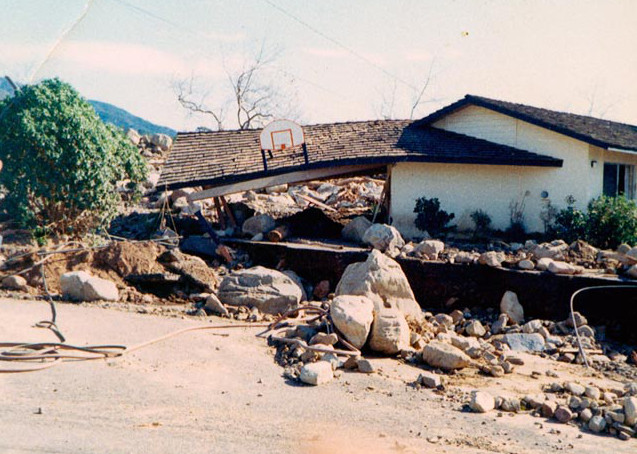
Monday, January 1, 7:46 p.m. Deputy Public Works Director Tom Fayram emails county officials with photographs of urban flooding and debris-flow damage triggered by heavy rainstorms that followed the 1964 Coyote Fire and the 1971 Romero Canyon Fire. More than 250 homes were destroyed in the 1964 flows. Jon Frye, a Flood Control engineer, responds: “Those roads act as the active channels. Saw the same even in ’95.”
Monday, January 1, 8:33 p.m. Fayram invites former director of County Flood Control Jim Stubchaer to lend his expertise. “I am wondering if you would be willing, and available to come to our County EOC [Emergency Operations Center] and talk about the Coyote Fire and Romero Fire and the floods that followed,” Fayram writes. “I think your unique perspective will help all of us, in particular your keen memory of specific issues.”
● ● ●
Stubchaer said he never received Fayram’s email. “I would have gladly met with Tom et al. had I known of the invitation,” he told the Independent. “I cannot explain the missing email.”
Tuesday, January 2. The OEM hosts a pre-storm strategy meeting with a large group of public-safety officials. They review the county’s Burn Area Contingency Plan, which highlights “areas of concern” along 17 canyons and creeks below the Thomas Fire burn scar. It states that more than 20,000 homes and businesses “could be in the path of either debris flows or flooding,” and it finalizes the mass notification language for evacuation warnings and orders. A handwritten note on a copy of the plan emphasizes: “Indiv. need to evaluate risk.”
Thursday, January 4, 9 p.m. Lewin emails Federal Emergency Management Agency (FEMA) administrators Dennis McKeown and Melissa Jensen a copy of the PowerPoint presentation he gave to the County Board of Supervisors at a January 3 special meeting. Lewin also includes a link to a blog published by former Montecito resident Chris Fenwick, who chronicled the near-destruction of his family’s Feather Hill Road home along Romero Creek during the 1969 debris flow.
Friday, January 5, 10:07 a.m. Sue Perry, a U.S. Geological Survey specialist who studies how public officials can more effectively communicate the dangers of impending disasters, reaches out via email to state and federal authorities monitoring the post–Thomas Fire situation. “After the Station Fire [the 2009 L.A. County wildfire], I interviewed debris flow evacuees and victims and have seen their misunderstandings play out during other SoCA debris flows,” she writes. Perry said these three points, among others, “couldn’t be stressed enough” in public messaging:
“Debris flows move as fast as 50 mph. If you wait to be certain a debris flow is coming your way, it will be too late to evacuate safely”; “Whether you will be safe to ‘shelter in place’ depends on how big the debris flow is and its exact path. Neither can be predicted”; and “You can’t use the weather where you are to know if it is raining up in the mountains where debris flows start.”
Perry also emails Lewin directly, offering to help. “Do let me know if my presence will assist,” she says. Jeremy Lancaster with the California Geological Survey (CGS) sends Lewin a similar message: “I’m hoping that County OEM and Flood Control will invite Dr. Suzanne Perry, Disaster Scientist, to the table in order to take advantage of her knowledge and experience in communicating post-fire hazards and risks to the public.”
● ● ●
Perry told the Independent that she didn’t meet with Lewin at that time but had “numerous interactions” with him “in the few weeks after 1/9.”
Perry said she initially reached out because she observed that “the official science-based web information all seemed to be wrong or misleading, and I wanted to try to correct some of the misperceptions.” Perry pointed to errors on ready.gov, the official website of the Department of Homeland Security, and “other FEMA products” the county was looking to for guidance.
The websites “describe storm problems that might occur at the same time — floods, mudslides, debris flows, flash floods — but don’t make clear that these are very different hazards, with different danger levels,” Perry said. The public is therefore left with the inaccurate impression that debris flows are similar to floods or mudslides, “more a nuisance than a killer.”
Friday, January 5, 2 p.m. Lewin’s “Flood/Debris Flow Risk” map is published on the OEM’s website and presented during a press conference on the imminent dangers of the approaching storm. Lewin urges residents to enter their home address into the interactive map to determine if they live in a danger zone. Other officials emphasize the unpredictability of the changing forecast and people’s responsibility for their own safety in the event of “mud and debris flows” or “flash flooding.”
Kevin Cooper with the U.S. Forest Service and Cal Fire’s Len Nielson both say it could take 15-20 minutes for a debris flow to travel from the mountains to the ocean. “So it’s very important to keep up your situational awareness of the weather,” Cooper says. “Understand your situation and make the correct decision yourself,” reiterates Sheriff’s Lieutenant Kelly Moore.
Lewin advises residents to register with the county’s emergency alert system. “But unfortunately,” he continues, “unlike in the fire, where we could merely say to evacuate ahead of time, sometimes evacuation isn’t the best choice. Sometimes the best thing for people to do is to go to their neighbor’s home that’s on high ground to get out of harm’s way. Sometimes the best action is to merely shelter in place.”
● ● ●
Survivors later complained Lewin and others gave mixed messages on how to seek safety in the midst of a debris flow. National Weather Service (NWS) meteorologist Eric Boldt clarified in a late-January interview that the best course of action is to stay inside and “go to the highest part of your house — an attic or even a countertop.”
Friday, January 5, 5:29 p.m. County spokesperson Gina DePinto announces the agenda for a planned Monday-evening community meeting. She discusses placing large copies of the “Flood/Debris Flow Risk” map around the room and setting up computer stations so people can look up their addresses; broadcasting informational presentations on CSBTV, Facebook, and YouTube; registering people with the county’s digital emergency notification program, Aware & Prepare; and providing Spanish interpretation.
Saturday, January 6, 10:58 a.m. Lewin emails more than two dozen county and state officials that the storm will very likely “cause debris flows in the burn areas.” He describes activating the county’s Joint Information Center (JIC), requesting additional hand crews and heavy equipment, and calling for evacuations of the “areas of highest impact.”
NWS meteorologist Boldt says three separate computer models predict heavy rain of 0.8 inches or more Monday evening through Tuesday morning. He concurs, “It would be wise to have people protecting their property or leaving as needed prior to this timeframe.”
Sunday, January 7, 12:32 a.m. The NWS upgrades the storm forecast to one to three inches of rain in coastal areas, two to five inches in the foothills, and six inches in the mountains. Rainfall rates are expected at half an inch to one inch per hour.
Sunday, January 7, 6:30 a.m. Given the upgraded forecast, Lewin suggests canceling the Monday community meeting. “We can reschedule for after the storm,” he says in an email. The meeting is formally canceled later that afternoon.
Sunday, January 7, 2:10 p.m. Scientists with the Thomas Fire WERT (California Watershed Emergency Response Team) supply a damage forecast map to county officials. It provides debris-flow predictions for a one-inch-per-hour rain event. Pink-colored polygons represent where floodwater and debris are likely to exit creek channels and spread across the region’s alluvial fan.
The map comes with a number of recommendations from WERT, including that Santa Barbara officials combine the WERT survey with federal, state, and local floodplain maps to create their evacuation boundaries. “These are not simple advisory points and polygons on a map,” stresses Jeremy Lancaster with the CGS in an email. “We strongly urge you to consider these data in your mandatory and voluntary evacuation notifications.”
● ● ●
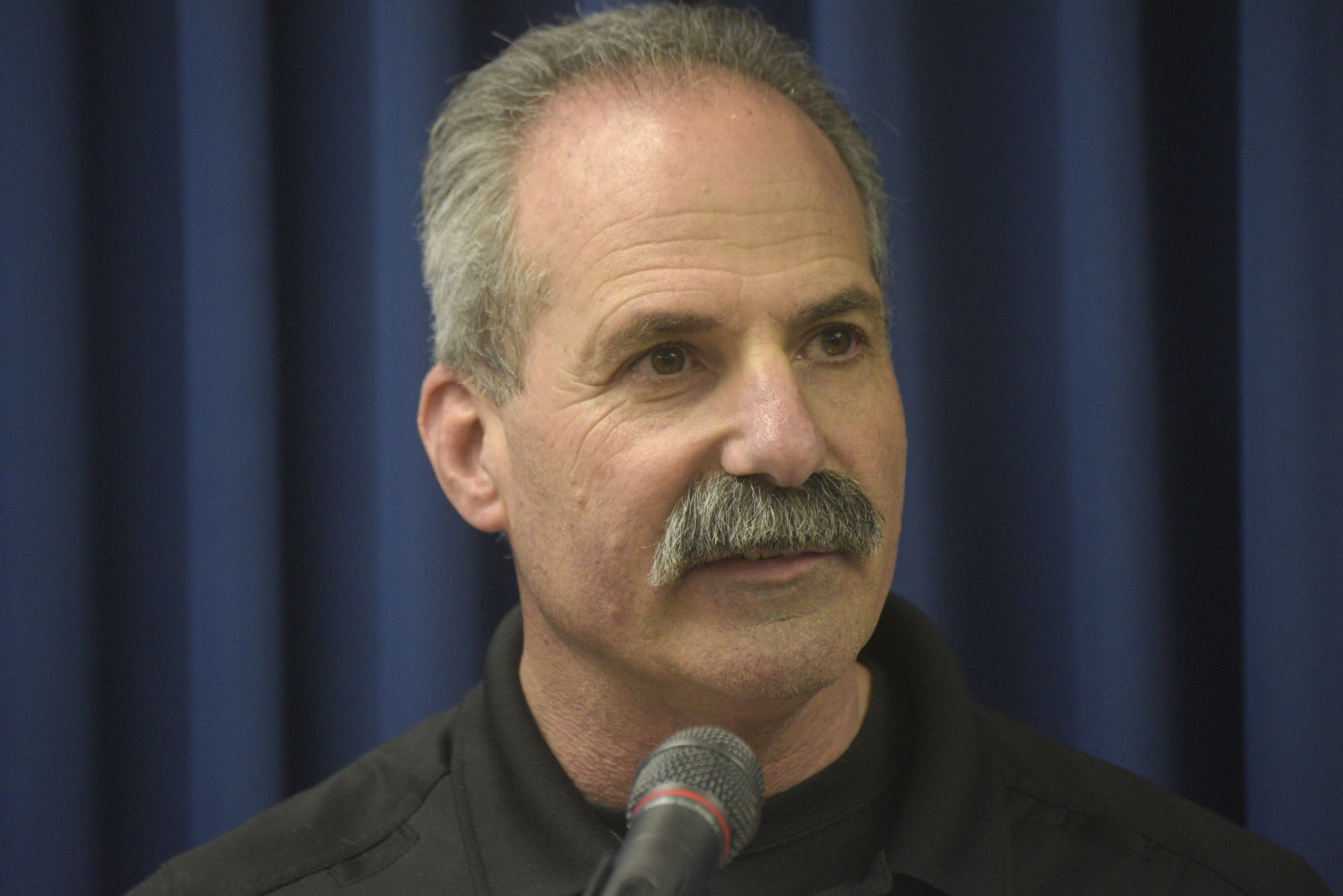
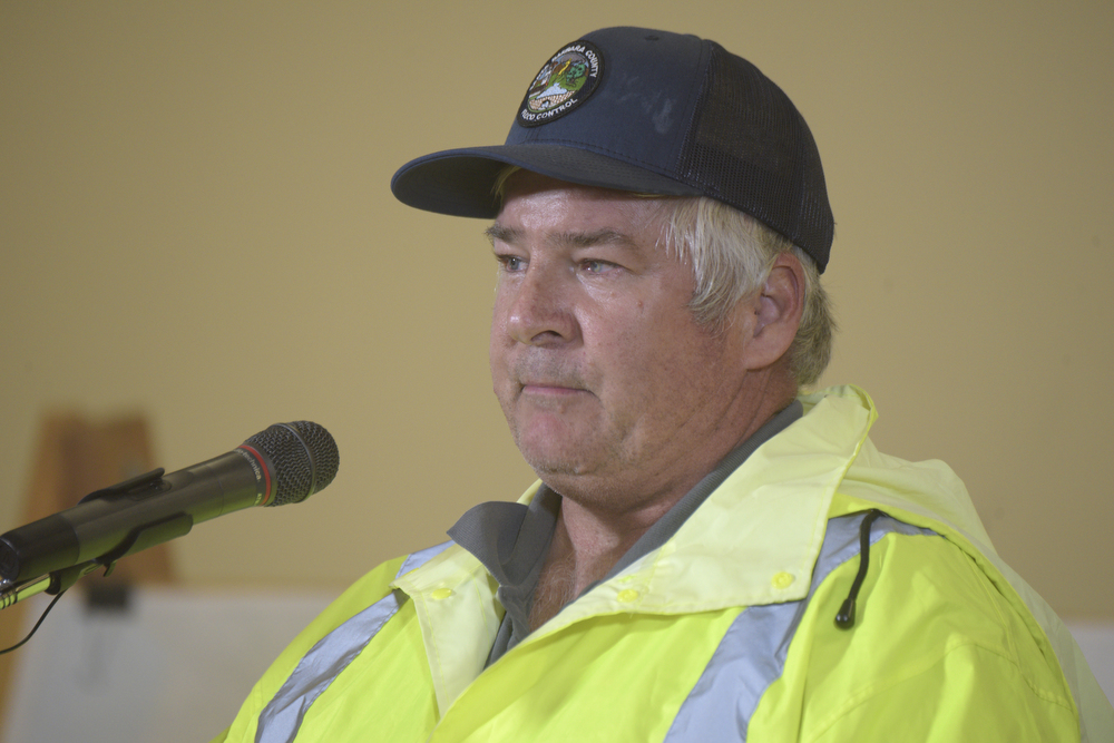
The WERT map was one of many planning documents the county used to draft its evacuation boundaries, explained Undersheriff Barney Melekian in a previous interview, though it was “probably the most definitive map product we had on January 7.” Fourteen victims died in neighborhoods designated as high risk by the WERT scientists but given only voluntary evacuation warnings by the county. “That map was a statement of possibility, not a statement of fact,” Melekian said.
Sunday, January 7, 3 p.m. A massive gathering of public-safety staff, Flood Control personnel, hydrologists, geologists, firefighters, and law enforcement officers convenes in the OEM’s main conference to deliberate on whether and how to evacuate Montecito. According to Santa Barbara officials, the only documentation of the meeting is handwritten notes taken by County Executive Officer Mona Miyasato and Undersheriff Melekian.

Miyasato’s notes, titled “Storm Flows,” reflect an overview of the hazards and the evacuation advice she’s given. She writes phrases such as “complex of ‘alluvial fans’ — don’t always know where” (emphasis hers), “channels then can jump across surfaces,” and “unpredictable.” She also jots down “‘Could’ have cataclysmic consequences?” and “No analogous experience in this area as no fires right in this area.”
A discussion is had about the La Crescenta debris flow of 1934, Miyasato’s notes show, when “~40 people died” and “14 -foot boulders moved.” “This is debris flow,” she continues, “rivers of mud, rock, and trees; ~ to avalanche — quick moving; first one after the fire is always the worst.” Under the heading of “Evacs recommended,” Miyasato writes, “County line and Parma Park, above [Highway] 192 — mandatory” and “below [Highway] 192 — warning.” Melekian’s notes read similarly.
● ● ●
In a later interview, Miyasato said she was surprised to hear the proposal to empty so much of Montecito. Just a few days earlier, she explained, the county’s plan was to continue its public education campaign. “It was hard to wrap our heads around it,” she said. “For those of us who aren’t in the business, who aren’t weather or fire experts, it was difficult to understand the danger. We don’t have a history of this.”
There was great concern over the “crying wolf” effect if the county cleared out Montecito and no storm came, Miyasato went on, and no neighboring jurisdictions, including Ventura County, were conducting evacuations. Debate at the meeting was freewheeling and impassioned. But by the end of the meeting, Miyasato said, the group decided to err on the side of caution. “And that’s exactly what we thought we did.”
Miyasato couldn’t recall who ultimately made the recommendation to use Highway 192 as the dividing line between voluntary and mandatory evacuation zones. “I really can’t remember,” she said.
Lewin said the guidance came out of an “operational group” meeting held at 1:30 that afternoon. “We emphasized it was a recommendation,” he said. “There was no rubber-stamping.” Lewin asserted there was simply no way for the county to predict the devastation the storm would bring, and he said previous Montecito floods never came close to delivering the same firepower. “There was mud on Coast Village Road,” he said. “People don’t die from that.”
Lewin acknowledged that at least one emergency manager voiced concern the evacuation zones didn’t follow north-south waterways and instead traced the geographically irrelevant east-west line of Highway 192. “But,” he said, “one thing to keep in mind is that action was taken on the entire [Montecito] area. Whether that action is acceptable by hindsight is up to all of you.”
Lewin emphasized that his team was racing against the clock — it had to absorb huge amounts of information and then make a decision before the storm rolled in. “Actions bring criticisms,” he said, “and I’ll take that criticism because we did something. We tried.”
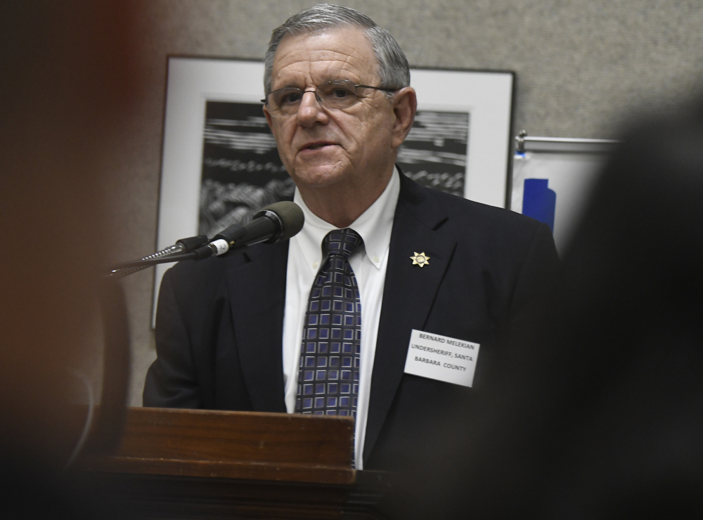
Melekian echoed previous comments from the Sheriff’s Office that the storm Montecito received was not the storm authorities expected. He recalled the debate around creating mandatory evacuation zones along creeks but argued that it couldn’t be accurately completed in so short a time. The Highway 192 demarcation was the clearest, safest way for the Sheriff’s Office to communicate different levels of danger to the public, he said. “Government’s job is to explain to people what the risk is.”
Sunday, January 7, 6:50 p.m. Mandatory evacuation orders are issued by the Sheriff’s Office to 7,000 Montecito residents living north of Highway 192. They are told to leave their homes “no later than 12pm (noon) Monday.” Voluntary evacuation warnings are sent to 23,000 residents south of 192. They are advised to “stay alert to changing conditions and be prepared to leave immediately.”
Lewin’s “Flood/Debris Flow Risk” map that spotlights danger areas on either side of creek channels is removed from the county’s website and replaced with the Highway 192 evacuation map. Conflicting information is relayed in the evacuation map and the OEM’s written description of the boundaries.
● ● ●
Lewin later said the maps were switched to avoid confusion. He stressed notifications went out 30 hours before the storm was predicted to strike, with no guarantee it would actually materialize. “That, frankly, takes guts,” he said.
County spokesperson DePinto said Lewin’s “biggest regret is probably that the map that showed the waterways was pulled.” She described the evacuation-boundary decisions as “complete conjecture on everyone’s part” and “stuff we will be deposed on in court.”
“I know it’s going to haunt people for the rest of their lives,” DePinto said.
Monday, January 8, 6:27 a.m. Lewin forwards another upgraded storm forecast from the NWS that now predicts two to four inches of rain in coastal areas, four to seven inches in the foothills, and up to nine inches along south-facing mountain slopes. Expected rainfall rates increase to 1.5 inches “under any thunderstorms that develop,” the NWS says.
Monday, January 8, 11:30 a.m. Santa Barbara County proclaims a local emergency due to the severe winter storm forecast.
Tuesday, January 9, 2:32 a.m. The NWS sends a warning of imminent flash flooding to cell phones in the Montecito region. “Flash Flood Warning this area til 5:30 AM PST,” it reads. “Avoid flood areas.”
Tuesday, January 9, 2:46 a.m. The OEM issues its own flash-flood cell-phone alert targeted to Montecito residents registered with the county’s Aware & Prepare program. “GO TO HIGH GROUND,” it instructs.
Tuesday, January 9, 3:34 a.m. A rain gauge at Casa Dorinda near Olive Mill and Hot Springs roads measures 0.54 inches of rain in five minutes.
Tuesday, January 9, 3:42 a.m. The OEM sends an all-bulletin warning — similar to an Amber Alert — through a federal wireless system that buzzes every Santa Barbara County phone within range of a working tower.
Tuesday, January 9, 4:05 a.m. Emergency dispatchers receive the first 9-1-1 call for a water rescue.


