
The mud and boulders from a prehistoric debris flow, the second-to-last major flow in Montecito, have been discovered by a UC Santa Barbara geologist at the Bonnymede condominiums and Hammond’s Meadow, just east of the Coral Casino.
The prehistoric flow may have occurred 1,000-2,000 years ago, said Ed Keller, a professor of earth science at the university. The “penultimate event,” as he calls it, came down a channel of Montecito Creek and was likely larger on that creek than during the disaster of January 9, 2018, Keller said. Of the 23 people who perished during the 1/9 Debris Flow, 17 died along Montecito Creek.
The long interval between the two events means that the probability of another catastrophic debris flow occurring in Montecito in the next 1,000 years is very low, Keller said.
“It’s reassuring,” he said. “They’re still pretty rare events, if you consider you need a wildfire first and then an intense rainfall. But smaller debris flows could occur, and you could still get a big flash flood. If people are given a warning to evacuate, they should heed it.”

During the past three months, Keller and Chandler Adamaitis, a UCSB graduate student in geology, together with several undergraduate research assistants, have photographed hundreds of debris-flow boulders hiding in plain sight in Santa Barbara and Montecito. In addition to the prehistoric debris flow on a channel of Montecito Creek, they found evidence of two or three on Mission Creek in Santa Barbara, and four or five in Rattlesnake Canyon, a tributary.
As in Montecito, Keller said, the team tracked a debris flow that occurred 1,000-2,000 years ago in Mission Creek; it dropped a boulder field in what is now Rocky Nook Park. But Santa Barbara, unlike Montecito, has not had a catastrophic flow in recent history, Keller said.
“The system is primed for a big debris flow in the Mission Creek basin, down to Rocky Nook, Alamar Avenue and State Street, and the Oak Park area,” Keller said. “There hasn’t been one for a thousand years, and there are a lot of boulders in the creek.”
Of course, Keller said, such a flow would most likely occur in the wake of a wildfire, followed by intense rain.
Keller’s team seeks to construct a chronology of prehistoric debris flows from San Roque Canyon to Montecito to determine how often they have occurred. All of Montecito and most of Santa Barbara were built on top of such flows.
To date, the team has studied seven boulder sites at parks, creeks, and parking lots, taking 20 measurements on each of the 20 boulders at each site. In all, they will study about 20 locations, Keller said. Boulder research, he said, is like going on “a giant Easter egg hunt. … You know they are out there, and you look for them.
“Until I looked,” Keller said, “I never appreciated the role of debris flows in our landscape. I was blind, and now I see.”
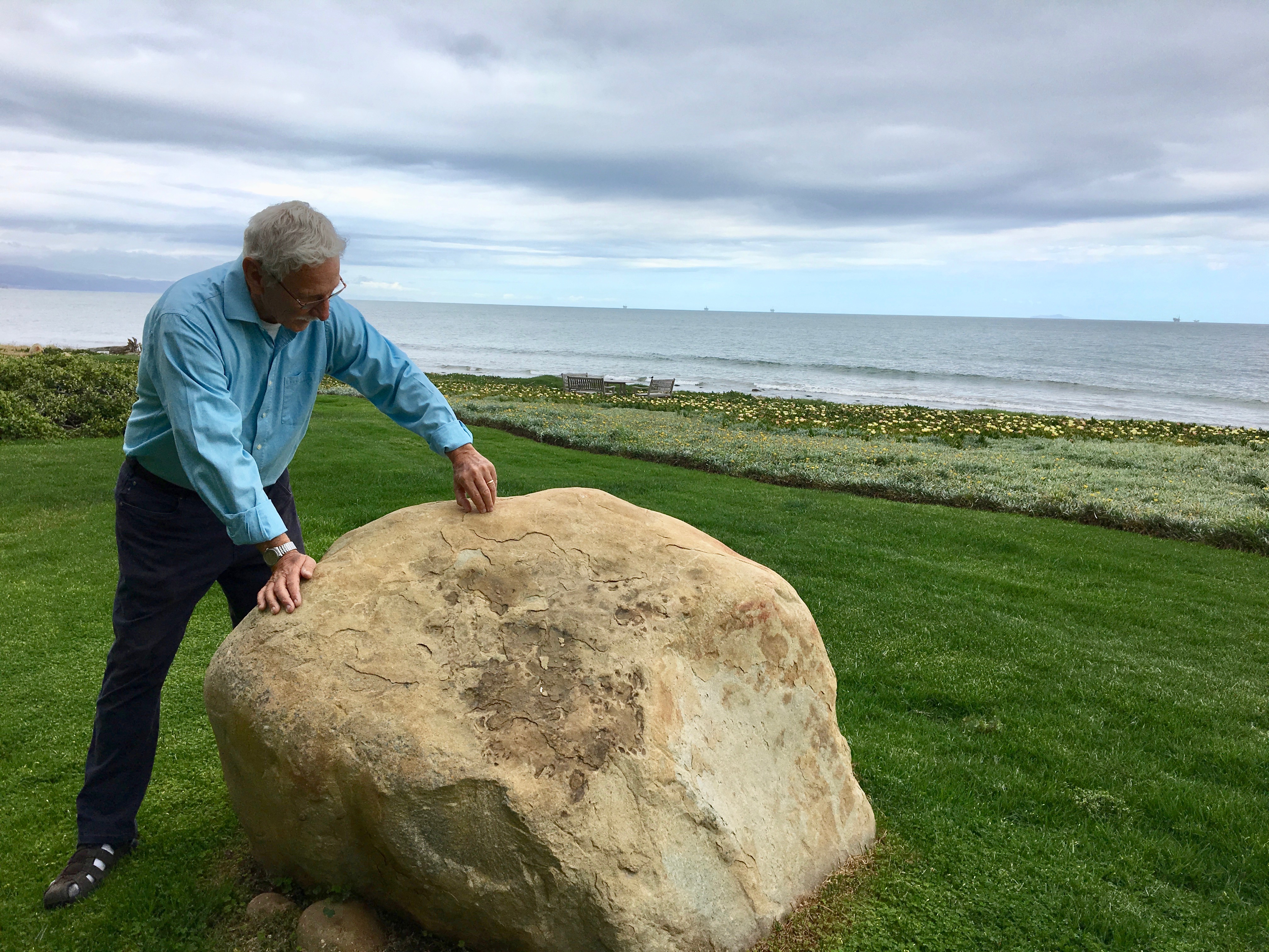
Boulders at Bonnymede
The 1/9 Debris Flow was the deadliest natural disaster in Santa Barbara County history; in addition to killing 23 people, it destroyed or damaged 470 houses and outbuildings along seven creeks in Montecito. The flow was triggered by extreme rainfall on the mountainside that was burned bare by the Thomas Fire.
Keller discovered the prehistoric debris flow in Montecito when he was investigating damage from the 1/9 Debris Flow near the Coral Casino. Nearby, he spotted some boulders on the lawn at Bonnymede, noting that unlike the boulders that came down on January 9, these had been rounded by erosion — a sign of much older age.
The boulders at Bonnymede also had what geologists call “weathering rinds,” orange-ish crusts that build up, layer upon layer, through oxidation. These rinds form on all rock surfaces that are exposed to the air. But because the rinds are scraped away during debris flows, the new rinds that form on boulders after they have been through a flow can reveal the approximate age of the flow itself.
The thicker the rinds, the older the flow, Keller said. On the Bonnymede boulders, they are about one-eighth of an inch thick.
Just east of Bonnymede, Keller found more evidence of the prehistoric flow in the exposed sea cliff at Hammond’s Meadow, next to a popular surfing beach. The meadow sits atop a seven-foot-high conglomeration of mud and rocks that was uplifted during a major earthquake. Each of the rocks in the cliff face is encased in mud.
“Most people would walk right by it, but this is the penultimate event,” Keller said. “It goes all the way to the trailhead at Hot Springs Creek.”
Just north of Hammond’s, Keller found an exposed cliff 15 feet high along the railroad tracks in Montecito — more evidence of the same prehistoric flow.
Hammond’s Meadow is preserved by the county as a Chumash heritage site. About 1,000 years ago, a Native American village was built on top of the debris flow there. Samples of charcoal from wildfire in the top layer of the prehistoric flow at Hammond’s will be sent to a lab for radiocarbon dating, Keller said. The results will help pinpoint the date of the flow within a few decades.

Telltale Rock Walls
Many boulders that came down in debris flows 1,000 or more years ago have been cut into blocks to fashion walls in Santa Barbara.
“You know you’re in debris-flow country when you start seeing numerous rock walls,” Keller said. “They’re all over the place.”
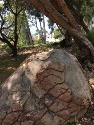
But some boulders likely haven’t moved an inch. At Oak Park, there’s a boulder seven feet high next to the tennis courts and one at the south entrance. Both are from the same flow at Rocky Nook 1,000-2,000 years ago. That flow was triggered by a landslide in Rattlesnake Canyon and came down Mission Canyon. It too appears to have been larger than the 2018 disaster in Montecito, Keller said.
The weathering rinds on the Oak Park boulders are “dead ringers” for the boulders at Bonnymede, Keller said — a sign that the two debris flows may have occurred in roughly the same prehistoric time frame. As at Hammond’s, Keller’s team will look for charcoal in the mud at other boulder sites for radiocarbon dating.
Going further back in geologic time, Keller’s team also found evidence of an enormous debris flow that occurred about 100,000 years ago in Rattlesnake Canyon; it scattered boulders across what is now the Riviera. The boulders from this flow have weathering rinds one half-inch thick; on many of them, the rinds have started to crack, forming polygons that look like turtle shells.
Earthquakes later pushed up the ridgeline that forms the Riviera, but boulders from the 100,000-year-old flow can be found today on either side of the ridge. One of them is visible behind the historic streetcar stop at Alameda Padre Serra and Lasuen Road. On the hillside above, and in Orpet Park below, are more boulders from this prehistoric flow, with their thick weathering rinds.
“Now, I can recognize really young, intermediate-age, and old-age boulders,” Keller said. “Isn’t that cool? The things you can learn if you look at the land that you never thought about before.”


You must be logged in to post a comment.