

Every 10 years, Santa Barbara County joins countless other cities, counties, and states in redrawing election district boundaries, based on updated Census data. This year was no different — except where it was.
The first difference happened in 2018, when county voters passed Measure G, which created a Citizens Independent Redistricting Commission (CIRC). The CIRC removes decisions about county supervisorial district boundaries from the self-interested votes of the supervisors themselves, placing them instead in the hands of 11 appointed commissioners representing all five districts (plus an at-large position). All were supposed to be appointed in fall of 2020, get updated Census data by April 2021, and finish the job by early autumn, with a rock-hard deadline of December 15, 2021.
Which leads to the second difference: COVID-19.
The pandemic delayed the release of Census data by more than six months, pushing the work of the CIRC perilously close to that December 15 to adopt a final map. Commissioners who expected to serve and be done in a matter of months found themselves looking at a year-plus process. That meant, ultimately, five resignations and a death. By the time the Redistricting Commission was ready to look at maps, there were more new commissioners than original appointees.
The public was encouraged to participate in a plethora of in-person and online workshops, and to submit maps. The hiccup: The mapping tools used by the CIRC’s consulting demographer, National Demographics Corporation (NDC), failed to update their Census data until early November, after the first deadline to submit maps. Maps submitted by that deadline had to be redrawn and resubmitted. Ultimately, the commission received more than 100 maps from the public, from which it first chose 10, then three, and finally one.
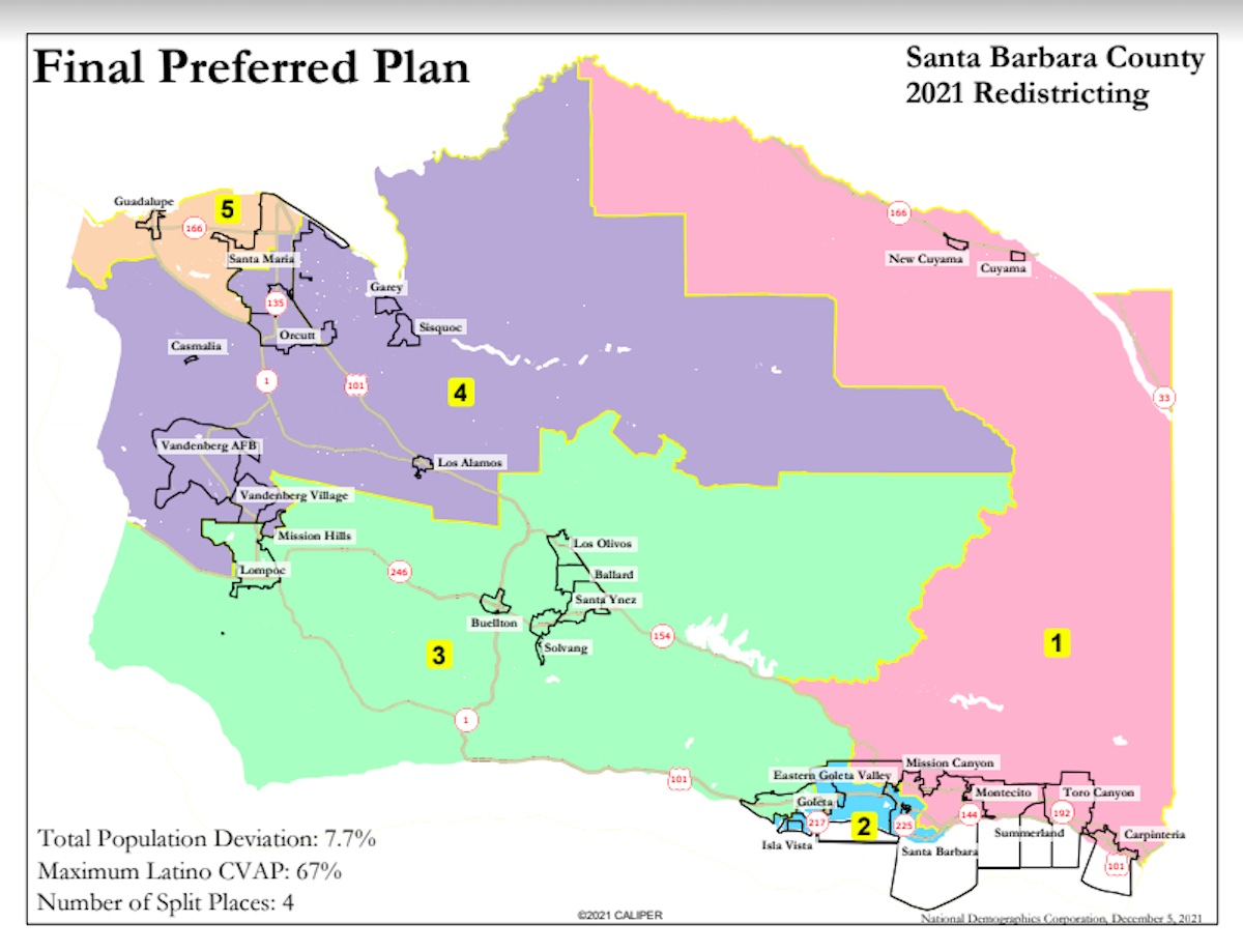
To no one’s surprise, Isla Vista was again at the center of controversy, as some Santa Ynez Valley voters objected to its continued inclusion in what they claim is a rural district — one that should not have to share its supervisor with transient, supposedly non-tax-paying university students. There was also extensive discussion of where to locate Cuyama, whose residents testified to their critical need for assistance with groundwater issues. To everyone’s surprise, Guadalupe became the other key point of focus and conflict.
Guadalupe has been moved around in each of the past three redistricting cycles, bouncing between the 4th, 5th, and 3rd districts (where it was placed in 2011). CAUSE (full name: Central Coast United for a Sustainable Economy) fielded hundreds of speakers arguing passionately to combine Guadalupe’s low-income, agricultural, and immigrant residents with most of Santa Maria as a community of interest. Other speakers, led by former Guadalupe mayor Frances Romero, argued that this would pack Latinos into a single district and deprive them of representation elsewhere. The Guadalupe City Council weighed in for the former, asking to be placed with Santa Maria, not Orcutt and the 4th District, where Guadalupe would have little in common except for students attending the same high school.
By the end of the day on Saturday, the former viewpoint had won.
The commissioners winnowed down their list to three finalist maps, then held a marathon session on December 4, choosing to start with a map submitted by longtime Republican activist Lanny Ebenstein. It was clear that the commissioners were trying to be responsive to the voices of various communities of interest. Over a four-hour period, they worked at a granular level, moving boundaries from street to street, changing the district position of whole chunks of cities, and ultimately voting unanimously to move forward with a kind of Frankenstein’s monster of changes. The creature is set to be formally adopted on Wednesday, December 8, at 6 p.m. in what is presumably the CIRC’s final meeting.
Throughout all the tweaking (some of which seemed pretty haphazard as the meeting went into evening hours), the issue was always population balance. By law, there may not be more than a 10 percent deviation in size between districts, so for every population-moving change made, another adjustment had to follow to restore the lost balance. Commissioners repeatedly asked staff for updates on the population deviation, number of split places (a consideration required by law), and most important, the Latinx Citizen Voting Age Population, or CVAP. (The CVAP is supposed to be high enough — a healthy majority — in any district that can be drawn that way, but not so high as to seem to “pack” minority voters all into a single district.) They then voted unanimously to move forward with the resulting hybrid.
As for what this means for the next 10 years in Santa Barbara County: The 1st District has the fewest changes, other than some boundary shifts to the west (including Tucker’s Grove Park and part of the Eastern Goleta Valley). As those more conservative Santa Ynez Valley voters had hoped for, the 2nd District now includes Isla Vista and UCSB but not big sections of Goleta that had been in the 2nd District — a swap that some speakers saw as gerrymandering, since this required sacrificing “compactness” by going around nearer populations to get to farther ones.
The 3rd District underwent the most change, with I.V. removed, most of Goleta moved in, Lompoc moved almost entirely into the 3rd District from the 4th, and the Lompoc Valley swapped into the 4th from the 3rd. The big surprise of the evening: after lengthy street-by-street tweaking of the 5th District boundary at the direction of At-Large Commissioner Jannet Rios, three-term Supervisor Steve Lavagnino found himself drawn out of his own supervisorial district. Given that he clearly intended to run for a fourth term, it remains unknown what his next step will be.
The Final Preferred Map is set to be formally adopted on December 8, 2021, at 6 p.m. in the Planning Commission Hearing Room at 123 East Anapamu Street. For more detail and to see which supervisorial district you now live in, visit tinyurl.com/newsupervisorialmaps and look at the Commission’s Final Preferred Plan.


You must be logged in to post a comment.