
By this time on Monday, downed trees, drowned roads, and dropped hillsides will be apparent from the “MAJOR amounts of rain” headed for the Santa Barbara coastline. The National Weather Service, giving its forecast with unusual emphasis, stated a wet and windy storm system will arrive on Saturday afternoon, hard on the heels of 3-5 inches of rain that saturated the ground just two days earlier.
In an update on Saturday morning, the NWS narrowed the height of the storm in Santa Barbara County to mid-morning Sunday through Sunday night. This is when “potentially life-threatening” amounts of rain could swell creeks and rivers, spilling runoff effects into urban areas and burn scars from the Thomas, Cave, and Alisal fires. The potential for thunderstorms and water spouts exists. San Luis Obispo County gets the brunt of the storm earlier Sunday morning, and Ventura and Los Angeles counties Sunday afternoon through early Monday morning as the storm moves from west to east.
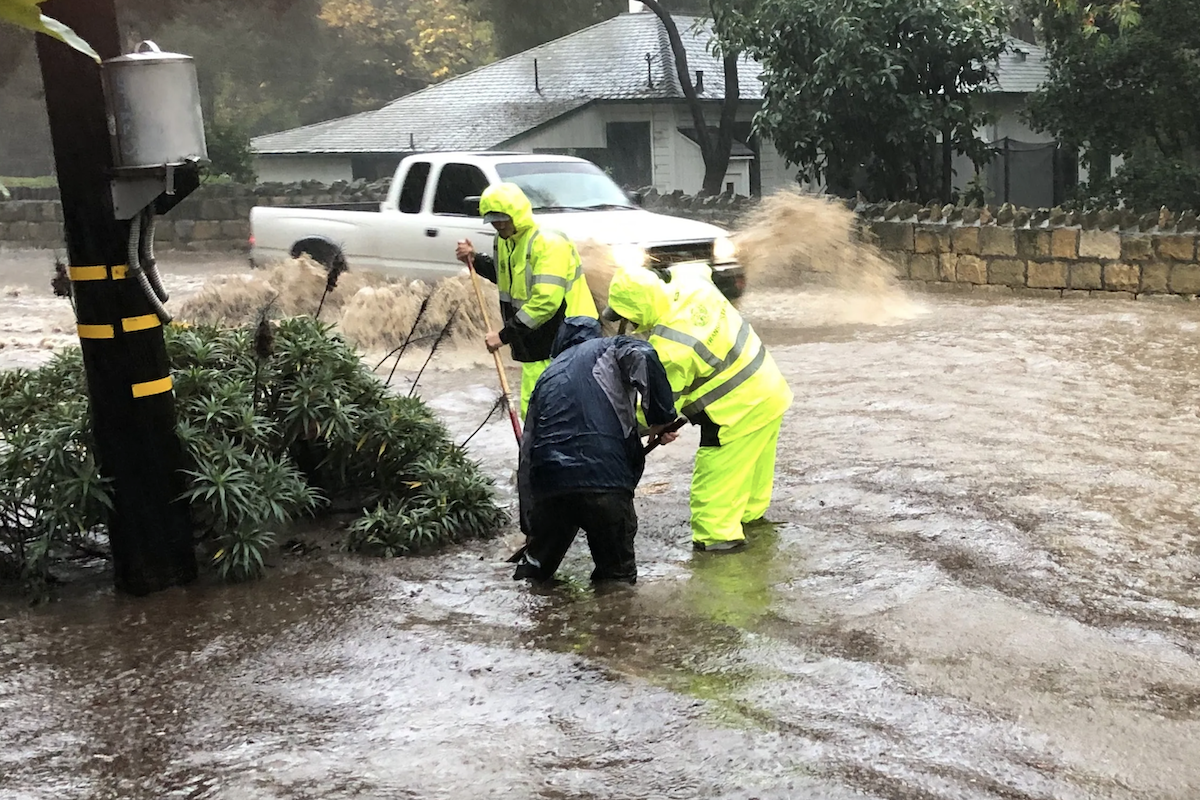
Evacuation “warnings” were issued on Friday afternoon by the county for properties “along waterways associated with the Thomas, Cave, and Alisal burn areas.” A large zone along Sycamore Creek from Montecito’s Stanwood Drive to the city’s Niños Drive is also under an evac warning. Should a flood be imminent, it is an “order” of evacuation that would go out.
Anyone who feels unsafe where they live is advised to go ahead and leave for safer places before any evacuation order is issued. Preparation is advised, such as ensuring vehicles are full of gas or energy, and important documents and items gathered together, should an evacuation order be announced. As well, saturated soils and high winds add to the possibility that electricity will go out and roads become impassable when large trees fall. To receive alerts of emergency storm conditions, sign up for ReadySBC Emergency Alerts here.
The approaching storm is moving in with a mass of clouds like the one that brought rainfall all night on February 1, this time bringing as much as 36 hours of solid rain. Along the coast and valleys, 3-6 inches could fall, and in the mountains, 6-12 inches. If the heaviest bands of rain stall over Santa Barbara or Ventura counties, as the NWS models predict, a half-inch of rain per hour is expected, and up to an inch per hour in the mountains, from Sunday night into Monday morning.
The potential for flooding, landslide, and mudslide was “significant,” said NWS meteorologist Ariel Cohen, south of Point Conception. Wind gusts of up to 60mph, and possibly 90mph in the I-5 corridor, will push the storm up the mountains, adding to the potential for as much as 15 inches of rain across southern Santa Barbara and western Ventura.
Cancellations are beginning to crop up: Santa Barbara Unified and the Hope Elementary School District notified families on Friday that their schools would be closed on Monday, February 5, because of the expected heavy storm conditions. SBUSD anticipated most schools would be closed around the county. Optional studies or make up work are available by contacting the appropriate district. The League of Women Voters cancelled the February 5 forum for 1st District county supervisor candidates.
On the sea, gale-force winds are expected by Sunday morning in the outer waters of the Channel Islands and nearshore waters of the Central Coast. Large breaking waves are predicted for south-facing harbors, such as Santa Barbara and Port San Luis. Surf could peak at 18 feet along the Central Coast and 12 feet in Ventura.
Flood watches in all areas — including urban areas — are likely to occur starting on Sunday. The Santa Ynez River is expected to rise as are all streams and small rivers. The Ventura River has a 25 percent chance of reaching a hazardous flood stage by Monday morning; during last year’s atmospheric rivers of rain, this caused the closure of Highway 101 overnight for several hours.
Snow levels will remain high — 6,500 to 7,000 feet — with two to four feet expected. As the week progresses, rain turning to snow at higher elevations could lower the snow level to 3,500 feet.

Sand and Bags
Outdoor chores will best be done on Friday and Saturday ahead of the storm, and sand and bags are available around the county: in Santa Barbara (4568 County Rd., Goleta), Santa Maria (912 W. Foster Rd), and Buellton (761 McMurray Rd.). In the City of Santa Barbara, sand and bags are at 401 East Yanonali Street and City Fire Station 7, 2411 Stanwood Drive from 10 a.m.-2 p.m. The City of Goleta has sand and bags set up at Fire Station 11 (6901 Frey Wy. and Storke Rd.) and Fire Station 14 (320 Los Carneros Rd.).
Be Prepared
During the storm and afterward when flood waters run off from hillsides, the county’s ReadySBC emergency preparedness website advises residents to:
• Stay away from burn scars, rivers, creeks, and other low-lying and flood-prone locations. Those living in areas prone to flooding should stay aware of changing conditions and be prepared to take protective actions, such as evacuating and sheltering in place.
• Roads impacted during previous storms may experience flooding and mud and rock slides. Communities along these roads may become isolated.
• Beaches, bluffs and the Harbor area may be impacted. This storm may trigger coastal flooding and erosion along the bluffs throughout the county. Residents and visitors are advised to stay away from beach areas.
• Strong winds can cause power outages. Charge important electronic devices and be prepared in case an unexpected power outage occurs.
• Secure belongings that could get impacted by strong winds such as outdoor furniture.
Resources
• For small animal shelter information, call Santa Barbara County Animal Services at (805) 681-4332.
• For large animal evacuation assistance, please call (805) 892-4484.
• For Evacuation Center assistance and additional information, contact the Santa Barbara County Call Center at (833) 688-5551.
• Storm readiness tips: http://www.readysbc.org/StormReadiness
• For status of highways: https://roads.dot.ca.gov/roadscell.php
• For status of county roadways: https://www.countyofsb.org/2116/Road-Closures


You must be logged in to post a comment.