
Even whales may feel the effect of the $1.6 billion threatened to be cut from the National Oceanic and Atmospheric Administration by Trump’s White House. Among the employees who’ve already lost their jobs with NOAA were two involved in whale strike research in the Santa Barbara Channel.
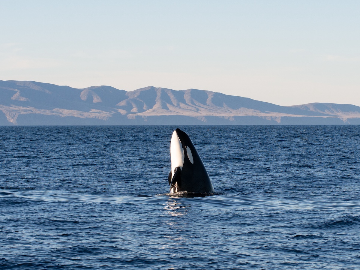
Douglas McCauley is a professor in marine ecology at UC Santa Barbara, and he’s long collaborated with NOAA employees to predict where endangered species of whales, like the blue whale, might be in order to notify fishing and other commercial ships. McCauley’s NOAA colleagues contributed important methods to analyze satellite data to improve forecasting of when whales were moving through the Santa Barbara Channel. Avoiding collisions between whales and ships not only protected endangered species but could also prompt fewer restrictions on ship travel.
“These scientists believed in the mission to work for the federal government to benefit the local economy they cared about,” said McCauley. “We have the potential for amazing future environmental leaders at UCSB, but this is now a loss of community due to the loss of jobs in NOAA.”
Rachel Rhodes, a marine scientist with UCSB, said that the satellite data served as a habitat model. It uses environmental conditions to predict where whales would likely be, providing a snapshot of whale activity in the shipping lanes as a reminder for ships to slow down. “It’s like a school-crossing zone for boats,” said Rhodes.
As one part of the whale-safe tools sent out to boat crews, this data fills in the gaps where other methods of whale detection may fall short.
Reducing ship speeds alone can reduce the number of ship strikes and the lethality of collisions, as it gives whales more time to move out of the way. Since 2020, cooperation with voluntary speed recommendations issued by NOAA and other federal agencies to reduce the risk of ship strikes has increased from 47 percent to 70 percent. “Whales have not yet evolved to perceive large ships as a threat,” said Rhodes. “Slowing ships down is the best and easiest tool.”
Rhodes said that NOAA collects all of the data on ship strikes and stores it in a database. “We rely on NOAA initiatives and data in facilitating this collaboration between researchers and mariners for tracking whales and reducing ship strikes,” said Rhodes. “It’s disheartening to think how these cuts might impact this collective partnership after 10 years in the making.”
UCSB has a NOAA office on campus, and the institutions work closely together. Nevertheless, there is also talk of a termination of NOAA office leases.
At a recent committee meeting with congressmembers discussing the cuts, Representative Jared Huffman (D-CA2) stated some 800-plus workers have been fired and that 10 percent of the NOAA workforce is either gone or on leave, with a projected 32 percent total employee cut proposal.
Impacts to the Catch
Aside from research, Ava Schulenberg, assistant director of Commercial Fishermen of Santa Barbara (CFSB), said that the nonprofit had been selected for a grant provided by NOAA, but the grant process has suddenly frozen. “None of our S.B.-based staff have been laid off yet, but it’s hard to predict because of the abrupt changes.”
Renee Sanders, a marine scientist with the Virginia Institute of Marine Science working with Commercial Fishermen on the grant, said, “Many projects federally funded with NOAA dollars are currently moving forward, but cuts to NOAA staff have left their team stretched thin. They are doing all they can to keep up with the high volume of projects they fund despite the loss of federal employees and outside contractors.”
Alongside state managing councils, fisheries along the West Coast are managed at the federal level by the Pacific Fisheries Management Council, which acquires research from NOAA fisheries. Milton Love, a research biologist at UCSB, said fish stock can be surveyed in two ways: Fisherman catch results can be assessed, which Love said is not always accurate, or NOAA deploys surveys to count fish. “But if that ends, then we won’t know how many fish there actually are,” said Love. “There’s no way of setting catch limits. No matter how you act, you have a strong chance of being wrong due to a lack of information.”
Chris Voss, who leads the Commercial Fishermen group, said there is now a concern that restrictions may grow. “When there is a possibility of data streams being interrupted due to impaired funding, overseeing agencies tend to default to super-conservative approaches,” said Voss. Past regulations have introduced quotas for fish stock, which have at times been too severe, according to Voss.
Voss referred to the Magnuson-Stevens Act which implemented restrictions back in the ’70s and has since been revised several times for being over-cautionary. Particularly on the West Coast, several species of overfished groundfish recovered more rapidly than predicted in the early 2000s. The Greater Atlantic region also experienced this, where severe restrictions were implemented on species that were neither overfished nor subject to overfishing. Yet, due to data surveys giving the population status of fish recovery, the jurisdiction slackened restrictions.
“They have not acknowledged that our framework is already designed for sustainable fishing,” said Voss. “We don’t want to be restricted just because of a lack of data.”
Professor Love said that these overly conservative measures were not a mistake in estimating the amount of fish, but in misunderstanding complicated ocean dynamics. “A case could be made that if we fished without surveying how many fish were present, then we wouldn’t know if populations ever recovered,” said Love. “The administration is now walking in willful ignorance.”
“People in general will not stop eating fish,” said Schulenberg. “We’re just going to end up importing it from other countries which may be less regulated.”

Stormy Weather Reports
Another topic of concern is whether the effectiveness of environmental emergency responses in the community will become limited.
Kelly Hubbard, who directs the county Office of Emergency Management, said, “We fully rely on the National Weather Service (NWS) for storm forecasting.” The NWS, being a component of NOAA, is sometimes the first alert to the Santa Barbara community with wireless emergency reports. Notifications range from flash flood warnings to tsunami monitoring by buoys. “Their office is staffed 24/7, but losses in staff can make their job more exhausting,” said Hubbard.
Hubbard also feared losing embedded officers who serve as a response precaution. In those cases, an NWS employee is sent to a weather emergency site to lend technical support on weather changes, almost as a consultant. “We don’t know if that will continue if staffing is reduced,” said Hubbard.
The NWS office that supports Santa Barbara is in Oxnard, which also oversees Los Angeles, Ventura, and San Luis Obispo counties. “If we have a big storm, their staff are providing weather reports for a very large area,” said Hubbard, which includes daily operations at the Santa Barbara Airport.
“I think they’ll get us the information we need, as they are passionate about what they do and the people they serve,” said Hubbard. “But this potential to lose our partners is really concerning.”


You must be logged in to post a comment.