
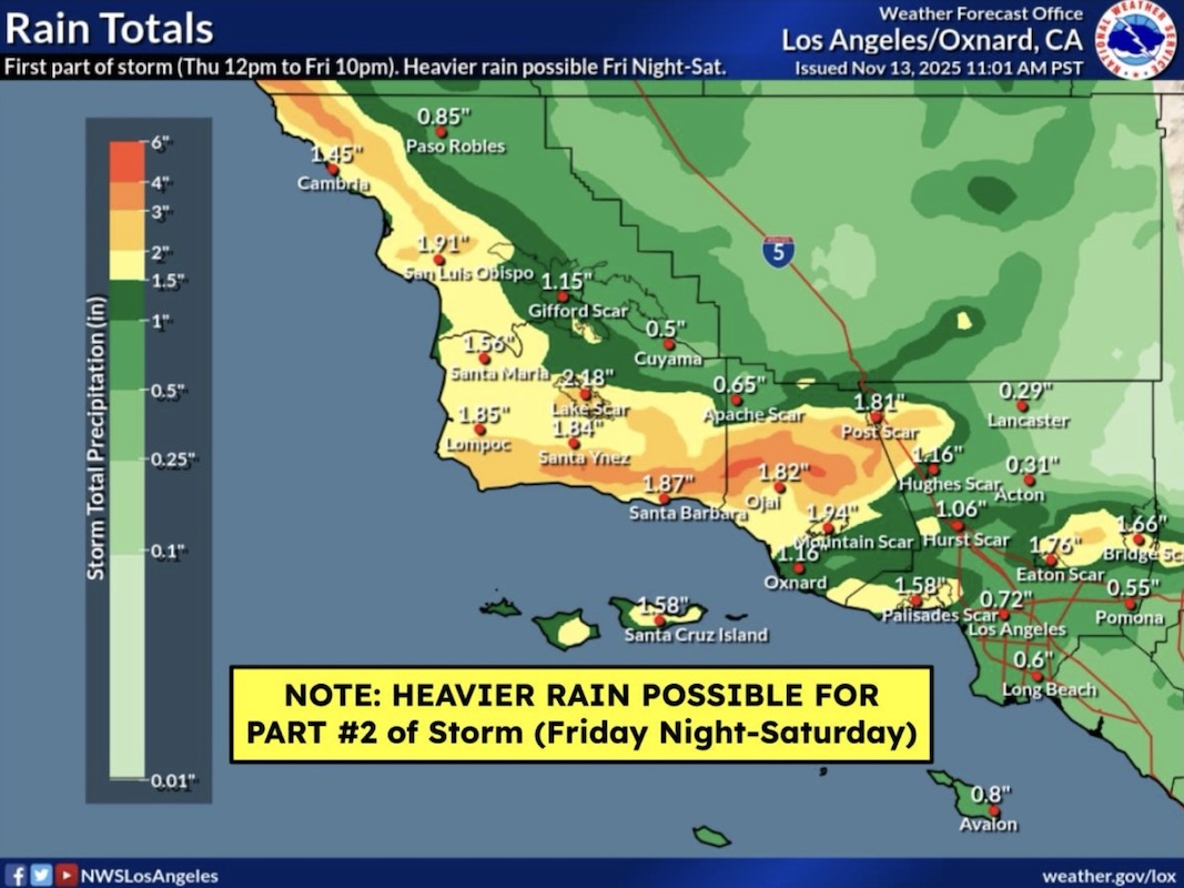
Santa Barbara County is under a Severe Flood Watch from midnight Thursday through Saturday evening, as the National Weather Service (NWS) warns of excessive rainfall capable of causing life-threatening flooding, debris flows, and power outages.
The storm, which is expected to intensify overnight, could bring rain rates of up to one inch per hour, particularly impacting the Santa Ynez Mountains, Santa Barbara’s southeastern and southwestern coasts, and surrounding foothill communities. High tides and large surf along the coast are also prompting concern for beach erosion and coastal flooding.
“This one’s not such a straightforward one,” said Jackie Ruiz, Santa Barbara County’s emergency preparedness communications and outreach coordinator, citing inconsistent storm models and “short bursts of heavier rain” that may catch drivers off guard. “The National Weather Service has told us that those known places are going to flood,” Ruiz said. “So it’s really important … to be mindful of that as [people] are traveling in the next few days.”
As of 4:45 p.m. Thursday, no evacuation warnings or orders have been issued, but officials are closely monitoring conditions around recent wildfire burn scars, including those left by the Lake Fire in the Santa Ynez Valley and the Gifford Fire along Highway 166. Coordination efforts are underway with San Luis Obispo County, where similar risks persist.
“Public safety officials have just encouraged everyone to take their own safety precautions,” Ruiz said. “We know about the places that flood locally … just be aware.”
In anticipation of the storm, sandbag distribution stations have been activated across the county, including two in Goleta:
- Fire Station 11, 6901 Frey Way (at Storke Road)
- Fire Station 14, 320 Los Carneros Road (next to the Stow House Museum)
The City of Santa Barbara also confirmed Thursday that its sandbag stations are operational from 8 a.m. to 4 p.m. on Friday, November 14. The materials are available for pickup at:
- Annex Yard: 401 East Yanonali Street, Santa Barbara, CA 93101
- City Fire Station 7: 2411 Stanwood Drive, Santa Barbara, CA 93101
Residents are advised to bring their own shovels, adhere to the 20-bag limit, and fill bags during daylight hours only. Supplies are available on a first-come, first-served basis.

Forecast
According to the NWS Los Angeles/Oxnard office, the first wave of rain is expected late Thursday night, with a stronger round developing Friday into Saturday afternoon, when rainfall could be heaviest. A brief lull is forecasted for Friday evening into early Saturday morning before showers resume.
The Santa Barbara coast is expected to see temperatures in the 50s, sustained east winds of 15–25 mph, and a 60–70 percent chance of precipitation through Saturday night. A High Surf Advisory is also in effect along the county’s Central Coast, with wave heights expected to reach 10 to 15 feet, as well as strong rip currents.
“There is the possibility of thunder with this storm,” Ruiz noted. “If folks do hear thunder, we do advise them to stay inside and to wait until the thunder has passed before going outside.”
The NWS has stressed that rainfall totals remain difficult to pin down due to an unstable low-pressure system off the coast. That system may stall, potentially extending the storm through Sunday or even into Monday.
Be Prepared
Local authorities are urging residents to take steps now to mitigate risk, including:
- Charge electronic devices, especially critical medical equipment
- Secure outdoor items vulnerable to wind, such as umbrellas and patio furniture
- Stay off flooded roads, and avoid riverbeds, creek beds, and recent burn areas
- Monitor alerts via ReadySBC, and visit ReadySBC.org for ongoing updates
“People should make a plan for their pets, too,” Ruiz added. “We often forget that part, but they’re part of the household.”
The County also advises those near cliffside areas, such as Isla Vista bluffs, to be particularly cautious, as coastal erosion may be triggered by the combination of surf and precipitation.
For road conditions, visit Caltrans QuickMap and County Road Closures.
Related Posts


Premier Events

Mon, Mar 23
7:00 PM
Santa Barbara
California Water: The Future of a Vital Resource

Sat, Mar 28
7:15 PM
Santa Barbara
Santa Barbara Stargazing Tour

Sat, Apr 18
5:30 PM
Solvang
The Winemaker’s Table: An Evening of Rideau Reds

Wed, Mar 25
6:30 PM
Santa Barbara
Vigil for Lament, Solidarity and Peace

Sat, Mar 28
All day
Santa Barbara
Coffee Culture Fest

Sat, Apr 18
11:30 AM
Goleta
The Santa Barbara Independent Backyard Brunch
Mon, Mar 23 7:00 PM
Santa Barbara
California Water: The Future of a Vital Resource
Sat, Mar 28 7:15 PM
Santa Barbara
Santa Barbara Stargazing Tour
Sat, Apr 18 5:30 PM
Solvang
The Winemaker’s Table: An Evening of Rideau Reds
Wed, Mar 25 6:30 PM
Santa Barbara
Vigil for Lament, Solidarity and Peace
Sat, Mar 28 All day
Santa Barbara
Coffee Culture Fest
Sat, Apr 18 11:30 AM
Goleta

You must be logged in to post a comment.