Kayaking Trips at Channel Islands National Park
Paddling the Galapagos of the North

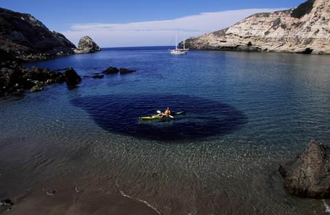
My friend Craig and I were nearing the end of our paddling excursion through Channel Islands National Park: a circumnavigation of Santa Rosa Island, followed by an open ocean sprint through pea soup fog to Santa Cruz Island, and an exploration of the natural wonders on that island’s craggy front side. We kayaked past volcanic sea stacks and configurations such as Profile Point, then paddled into the Dardanelles, where we ducked under triangular and keyhole-shaped arches. But it was the black mass that swarmed beneath Craig’s kayak at Potato Harbor that we remember most.
We couldn’t have asked for cleaner paddling conditions: no swell or wind, and the water clarity mirrored the South Pacific. We’d paddled the entire front side of the largest island in the archipelago without a break, and decided to stretch our legs at Potato Harbor, the last protected cove before Scorpion Anchorage on the southeast end of the isle.
As soon as our hulls scraped wet sand, that black mass appeared in the waist-deep water. A gazillion silverfish bonded into a giant baitball. Stiff-legged, Craig gently shoved his kayak back into the protected waters of Potato. Perhaps instantly drawn toward his multicolored vessel, the baitball swayed beneath him, a sort of aquatic ballet and another Channel Islands natural wonder within the ebb and flow of a draining tide.
But don’t take my word for it. There’s plenty of easy paddling to be had at the Channel Islands, so to get your feet wet, here are three daytrips slightly off the beaten path:
Scorpion Anchorage to Potato Harbor: 6 Miles Roundtrip
Scorpion is the most visited anchorage in the national park. It’s where most paddling trips begin and end, where Island Packers drops day-trippers, campers, and kayakers. A paddle west to Potato Harbor, however, will move away from a crowded beach and campground at Scorpion, while absorbing a little solitude beneath sheer cliffs, squawking gulls, and posturing brown pelicans.
Generally, a morning paddle is the call, the best opportunity to avoid the perpetual northwest winds that kick up in the afternoon. There are more sea caves on the Channel Islands than anywhere in the world, and some of the best spelunking in the chain is along this stretch. Monikers like Sharks Tooth, Cavern Point, and Neptune’s Trident may sound fittingly daunting, but just don a crash helmet when you head inside the honeycombed, wave-battered cliffs that are still evolving to this day.
Potato Harbor is one of the most idyllic harbors in the chain. It’s shaped like a crab’s open pincer, inviting you inside its tranquil depths. You can easily spend the entire day here snorkeling, exploring, paddling, relaxing, and wildlife watching.
Prisoners Harbor to Twin Harbors Arch: 3 Miles Roundtrip
This is one of the most scenic paddles on the front side of Santa Cruz, and the most biodiverse islet off the coast. Located west of the isthmus and Chinese Harbor, this paddle is in stark contrast to the paddle to Potato Harbor. What the Prisoners paddle lacks in spelunking it more than makes up for in terms of breathtaking scenery. Unlike the southeast end of the island, Bishop Pines, endemic island oak trees, and giant coreopsis choke each canyon emptying into the ocean.
Spotting a recently reintroduced bald eagle is a strong possibility, and glowing orange garibaldi, harbor seals, and pigeon guillemots are constant companions. Two impressive arches beckon a paddle through, but mind the tide and waves washing through. Timing is everything here, or you might find yourself teetering on a barnacle-encrusted rock. High tide works best for these wave-battered works of volcanic art, but low tide is better for the few grottos along this stretch, which are completely concealed by a full tide.
Bechers Bay to Carrington Point: 4 Miles Roundtrip
From spring through fall, Island Packers drops day-trippers and campers off at the historic pier at Bechers Bay on Santa Rosa Island. There are more than 200 documented sea caves on Anacapa and Santa Cruz, but most people don’t know that there are actually more along Santa Rosa’s shores.
Bechers is a colossal, crescent moon-shaped bay, and its beautiful coastline possesses interesting rock formations. The best way to explore this remote section of the island is by kayak, and more than likely you’ll have it to yourself. While Island Packers waits a few hours for the day-trippers, you can sneak off on your own, paddling under fantastic arches and negotiating sea caves. As Carrington Point looms on the horizon, expect an increase in swell and wind and a throng of seabirds, seals, and sea lions. When it’s time to turn around, it’s an effortless paddle back to the boat with swell, current, and wind at your back.
 Books: San Miguel Island: My Childhood Memoir 1930-1942, by Betsy Lester Roberti
April 2008, Santa Cruz Island Foundation, 130 pages, $15
Living on one of the Channel Islands is a fantasy for almost every nature-loving Californian-except for Betsy Lester Roberti, who lived there during her formative years. This is her memoir of island life from birth to age nine, an otherworldly childhood tale of finding Chumash artifacts and skulls, having bald eagles and island foxes as pets, and discovering the mysteries of the sea, from seals to Japanese glass buoys. Her family ran sheep on San Miguel out of Rancho Rambouillet until her father chopped off two fingers one day, became depressed from the medication, and took his own life in 1942. It’s a personal and easily told story, and the perfect complement to the book The King of San Miguel, her mother’s memoir of her dad, Herb Lester. Available in S.B. bookstores, or see scifoundation.org for more info. – Matt Kettman
4*1*1
To reach the islands with your own kayak, call Island Packers at 642-1393 or see islandpackers.com. For a guided tour, call the Santa Barbara Adventure Company (898-0671, sbadventureco.com); Channel Islands Kayak Center (984-5995, cikayak.com); Paddle Sports of Santa Barbara (899-4925, kayaksb.com); or Aqua Sports ([800] 773-2309, islandkayaking.com).