
According to data collected by the National Oceanic and Atmospheric Administration’s (NOAA) Weather Service, El Ni±o conditions-meaning warmer ocean temperatures than usual-are officially upon us. Although regional weather during an El Ni±o winter season can range from very dry to very wet, city, county, and federal officials are planning for the latter.
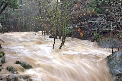
A wet El Ni±o season has the potential to cause flooding and dangerous debris flows from mountain areas denuded by recent wildfires. “There’s a pretty good indication that if we have El Ni±o conditions, we’re likely to have high rainfall,” said Jayme Laber, senior hydrologist at NOAA’s Oxnard office, at a Santa Barbara County flood preparedness information meeting Wednesday evening, September 23. Average rainfall in the area is usually 14 to 15 inches per year. Laber said that while he can’t be sure, his estimate is edging more toward 20 inches for this year.
The same alert-level classifications apply this year as in previous years. NOAA issues an “outlook” if a storm may occur within a few days. When a “watch” is issued, it means a storm could cause flooding in six to 12 hours. And a “warning” means residents in the affected area may see dangerous flooding or debris flows within five to 45 minutes.
The U.S. Geological Survey has a flash flood monitoring system in place, including radar and rain gauges tied into an Internet-based mapping system, to provide real-time updates. Even with all of the technology it has available, NOAA enlists the help of volunteers to call in reports and monitor conditions in their particular area. Laber encouraged members of the public to contact his office to receive training. Detailed weather and flood information can be obtained on the Weather Service’s Oxnard branch Web site, which covers Los Angeles, Ventura, Santa Barbara, and San Luis Obispo counties.
With three major front-country fires in the last year, the Santa Barbara County Flood Control District has been busy preparing for the dangers a rainy season could bring. On July 7 of this year, the County Board of Supervisors approved the Jesusita Fire Emergency Watershed Response Plan, which includes clearing streams of debris, hydromulching burned areas, and installing debris racks in the upper reaches of creek beds to catch large objects before they make their way downhill to populated areas. Most of the work has been completed, said Flood Control District chief Tom Fayram, and area residents may have noticed small planes dropping hydromulch-an organic paper mixture designed to stabilize denuded hillsides-in the Jesusita Fire burn area. “All that’s left [to complete] are a couple of debris racks that the City of Santa Barbara got funding for from [the National Resource Conservation Service] recently,” Fayram said.
Although the county is nearly finished with its flood season preparations, Fayram said homeowners have an equal responsibility to be prepared for the worst. (In 1995, a number of houses along the Mission Creek corridor-from the Cottage Hospital area all the way down to Canon Perdido Street downtown-were damaged during heavy winter rains. This year could bring even worse flooding.) “Everyone should be preparing right now. It never fails to surprise me that the day before a storm, we get inundated by calls from people asking for sandbags. There are way more of you than there are of us,” he said, encouraging people to stock up on sandbags and get their properties ready for debris flows now. With a limited number of flood-response personnel, the Flood Control District’s resources will be spread thin during actual flooding. Fayram also cautioned homeowners and renters against waiting until the last minute to purchase flood insurance, noting that most policies have a 30-day waiting period before they take effect.
In concert with the Sheriff’s Department, other Santa Barbara County officials are putting the finishing touches on an evacuation plan and should soon have more detailed information about which areas are at high risk for flooding. For the time being, Fayram encouraged people to consult FEMA’s flood risk maps for more information.
Jeff Banks, head of the Sheriff Department’s Law Enforcement Operations Division, said that 300 regular deputies and 180 corrections deputies will be on hand to help with evacuations and traffic movement in case of a disaster. Law enforcement response will be limited to in-progress crimes, but Banks did not anticipate any reduction in the Sheriff Department’s capability to handle active emergencies and protect property from potential looters. He said that although there was little looting during the Jesusita Fire, a Los Angeles deputy on loan to Santa Barbara County stopped someone who claimed to be a homeowner from entering an evacuated home. “When they were looking down the wrong end of a gun barrel, they realized that we were serious about protecting their property,” he said, adding with a chuckle that they turned out to be the actual homeowners in that case.
In order to facilitate what Banks called a more surgical approach to evacuations, Santa Barbara County has refined its Reverse 911 system to include, in addition to listed and unlisted landlines, up to two cellular phones per household. Capability to send alert messages to email accounts is expected to be added in the near future, and anyone interested in adding their mobile phone number to the database can do so through the Sheriff Department’s Web site. Additionally, the American Red Cross has its emergency shelter plan ready, and will be holding several emergency preparedness meetings this fall. For more information, call Santa Barbara Chapter of the Red Cross at (805) 687-1331.


