
Drawing New Lines
Isla Vista Still Sticking Point in Rework of Supervisorial Districts
When it comes to county politics, Isla Vista has a hard time staying above the fray. That was clear 10 years ago when the Board of Supervisors was tasked with redrawing the lines of the five supervisorial districts, it was clear Tuesday when they began discussions to redraw the lines for the next 10 years, and it’s been clear with every election and discussion of splitting the county in between.
There’s no mistaking that the 3rd District (which contains Isla Vista and UCSB) is the swing district between two more conservative North County districts and the two South County districts, which are more left-leaning. Over the last 20 years, however, things have really picked up. The 1990 census showed a population increase creeping north and overall more evenly spread, and the board redrew the lines to reflect that shift, making the 3rd District a teeter-totter district. Since then, the seat has gone back and forth between candidates who have represented the more environmentally concerned, anti-growth South Coast, and North County candidates who were pro-business and pro-growth.
In 2001, there was a push to move Isla Vista’s district line, but it remained in the 3rd District. Since that redistricting was done, there have been two supervisorial elections. In one election the conservative Brooks Firestone was elected, and liberal Doreen Farr took the seat in 2008.
But now, with a population shift even further to the North County, the push to move Isla Vista out of the 3rd District — where it’s been for 127 years — has become stronger than ever. Many residents of the Santa Ynez Valley came out, telling the supervisors Tuesday that they had nothing in common with Isla Vista, a small, coastal community filled with both college students and lower-class families. “The valley does not have a similar community of interest with UCSB and Isla Vista,” said former Solvang city councilmember Ed Skytt, who submitted a map of his own. One public commenter suggested that Isla Vista’s “per capita keg consumption” was too high for the valley. “Please avoid looking for the 85,000 people most likely to reelect you and look for the welfare of all of us,” said Olivia Flisher, a Santa Ynez Valley resident.
“Isla Vista residents are treated, in rhetoric at least, as if they have the plague,” said Santa Barbara resident Mickey Flacks.
Others, however, took offense to the way the small community was being spoken of. “Isla Vista residents are treated, in rhetoric at least, as if they have the plague,” said Santa Barbara resident Mickey Flacks. They said that moving Isla Vista into the 2nd District, which includes parts of Goleta and Santa Barbara, wouldn’t necessarily be a good fit either.
With the progressive board majority in control, the push to move Isla Vista is not going to happen. A motion by 5th District Supervisor Steve Lavagnino, whose district has grown by 16,000 in the last 10 years, to split UCSB from Isla Vista failed. He pointed out that several cities — Santa Barbara, Goleta, Santa Maria, and Lompoc — were all divided and represented by two districts, and UCSB and I.V. could go in separate districts, as well.
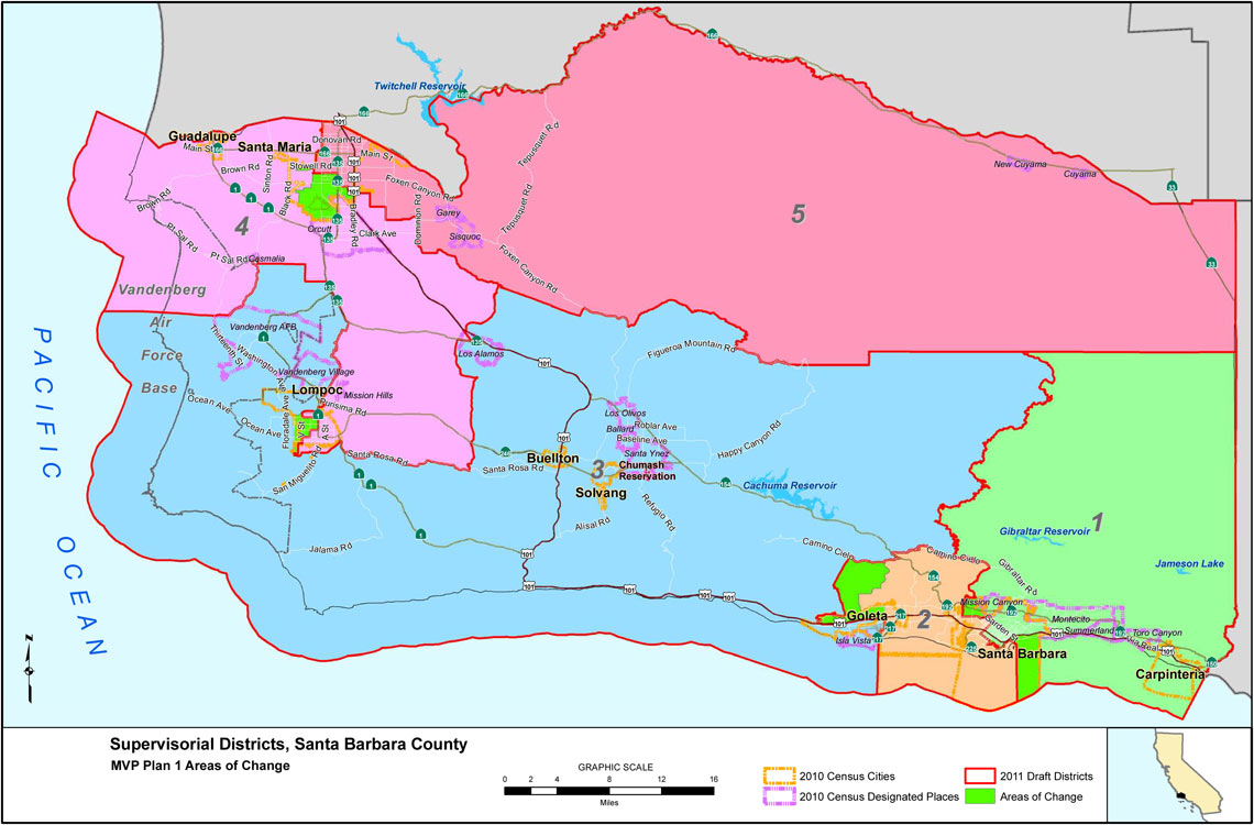
The board majority, however, focused in on one of 16 maps turned in by members of the public, one submitted by George Relles, who named it “MVP Map” for Maximum Voter Protection. In his presentation to the board Tuesday, Relles — a heavy supporter of many progressive South Coast candidates over the years, including the board majority — said his proposal moves the smallest number of people. “Displacing members of our communities is of upmost importance to me,” said 2nd District Supervisor Janet Wolf, echoing the sentiments of others. “Those maps impact the least amount of people.” Relles’s proposal adds more than 8,000 people to the 1st District and takes more than 16,000 away from the 5th. The greatest percent of change occurs in the 3rd and 4th Districts.
While there are a lot of permissive criteria — like using topography, geography, or contiguity when figuring out district lines — there are only two mandatory requirements: The lines must be drawn in accordance with the Federal Voting Rights Act and need to be equal in population, which, at current levels, is 84,779 per district.
Because of a ballot initiative, the statewide process of redistricting state and federal congressional seats was taken out of the hands of politicians and made public. A commission was formed to redraw the lines in a fair, balanced way that didn’t gerrymander districts to make them safe for the politicians who sat comfortably on one side or the other.
But locally, the Board of Supervisors is still in charge of redrawing the boundaries that outline the districts they represent. That might not be the case next time around, however. Not only did some boardmembers suggest that the public should be in control, but board agitator Andy Caldwell of COLAB suggested his group would create a ballot initiative to take the power away from the board once and for all.
Regardless, it’s too late this time around, and the process will continue to move forward. The Board of Supervisors has until the end of October to finalize the lines.


