


Name of hike: Coldwater Camp Dayhike
Mileage: 8.5 miles pleasant rambling (goes past Coldwater Camp); suitable for sturdy children
Suggested time: most of one day (includes drive to Santa Ynez and to Nira Camp)
Richard Louv’s seminal new book, The Nature Principle, offers insightful ideas about how critically important it is to visit wild nature as often as possible. He asks us two wonderful questions, which I want to pose to readers: “What would our lives be like if our days and nights were as immersed in nature as they are in technology? How can each of us help create that life-enhancing world right now for our families and for ourselves?”

My essential goal in writing these columns is to entice people into turning their backs on the seductive sea and to face the great interior, the Santa Barbara County backcountry. She’s a very raw nature just beyond the coastal range, much less polluted than our filthy beaches and tar-stained littoral here in the congested city.
One enters the rugged San Rafael Wilderness by driving 47 miles north from urban Santa Barbara. It’s east of Santa Maria, north of Santa Barbara, south of Bakersfield, and far from our crowded sands.
Driving into Nira Camp for this day hike I notice that the California golden poppies are blooming along some of Happy Canyon Road’s rough fringe and thus realize spring hath already sprung in the Santa Barbara backcountry. Along the San Rafael Mountains’ dark northern slopes winter holds on, but the ascending sun warms the drier southern hillsides, which remain in desperate need of more precipitation.
After the pleasant 90-minute drive from Santa Barbara’s Westside, I leave the truck parked near Nira Camp, but a few hundred yards west, where Davy Brown Creek dumps into the larger Manzana Creek. The Coldwater Camp hike (which can extend further, to another no-name free camp) is a glorious excursion, with the singing creek always in earshot and usually in view: You will cross the stream many times. On this venture, which I made on February 2, 2012, I managed to ford and keep the boots dry every time with dexterous use of the hiking poles. Be advised that after significant rain some of these fords are impassable, notably at Potrero Camp.

Crossing Davy Brown Creek, you immediately see the pale gray sign reading San Rafael Wilderness and continue hiking high on the left side of the Manzana, heading west, following the visible flow of the watercourse far below. The old wooden sign that is also there identifies our path as the Manzana Trail and gives outdated mileages to Potrero and Coldwater Camps. During our trek we will encounter three U.S. Forest Service campsites, each replete with tables and iron fire rings where campfires may be safely made. This area is generally called the lower Manzana.
After 1.3 miles of hillside trekking the trail drops steeply down into Potrero Camp right on the Manzana Creek: one solid table and stacked firewood greet this hiker. It’s a fine overnight spot if hiking with very young children or rookie backpackers. Pushing on, the day-hiker quickly fords and sees the two ancient, corrugated iron trail signs giving the seeker a choice: the ascending trail to the right is the Potrero Canyon Trail — the subscript says Hurricane Deck Trail, and the whitish Hurricane Deck can be seen looming above, to the north, but we did that jaunt on the last hike. Straight ahead, and following the watercourse way, is the second iron sign, stating Manzana Trail and understating the distance to Manzana Schoolhouse Camp at the Sisquoc River as six miles.
We stay low with the Manzana Creek Trail and continue 1.5 leisurely miles to Coldwater Camp, staying on the watercourse way, inhaling the smells and harbingers of early spring like the dark green winter grass in some of the potreros. We also struggle with reeds and rocks on some of the many creek crossings. I’ve seen ducks, turtles, and deer on previous trips, but they all escape my seeking eye on this day.
The 1993 Marre Fire singed the large and lovely Coldwater Camp meadow pretty badly, killing almost of the tall gray pines, but it’s come partway back, and there are two good campsites with tables here, and the creek water is usually reliable. (Filter it.) In later spring, watch out for the good old Boy Scouts, since these intrepid groups often camp at Coldwater, overrunning the entire meadow while having great fun. They sometimes bring in stock, pretty much trashing the meadow.

I continue walking on past Coldwater for 1.5 miles until I enter another splendid unnamed potrero, which some of us have labeled Double Meadow and others Horseshoe Meadow or Horseshoe Bend. Double back around the tiny ridge and softly tread into the two gorgeous “free camps” there, halting at the large pool. These are outback camps and better than the official USFS sites since less used and therefore less polluted. In just the last few years some folks, likely horse riders, have made a homemade metal sign with a cool engraving: Horseshoe Bend.
At the main camp here, right beside the large, deep pool (about four and a half feet), take a break at the handy table and admire the stonework at the campfire site with its iron grate. Have lunch here; enjoy a brief siesta. Even in February it is fairly warm, so I skinny dip in the pool. It is resuscitating, reviving, restoring, resplendent with bright solar beams.
During the reluctantly undertaken return trip, the outdoor beauty of nature here overwhelms a human walking back through pristine Double Meadow away from the Manzana. I’m practicing silence and moving quite slowly. It is wonderfully quiet. There are few bird cries and not much rustling in the low brush. My small camera is in my hand. There’s a sense of some creature watching, so I halt and stare around.
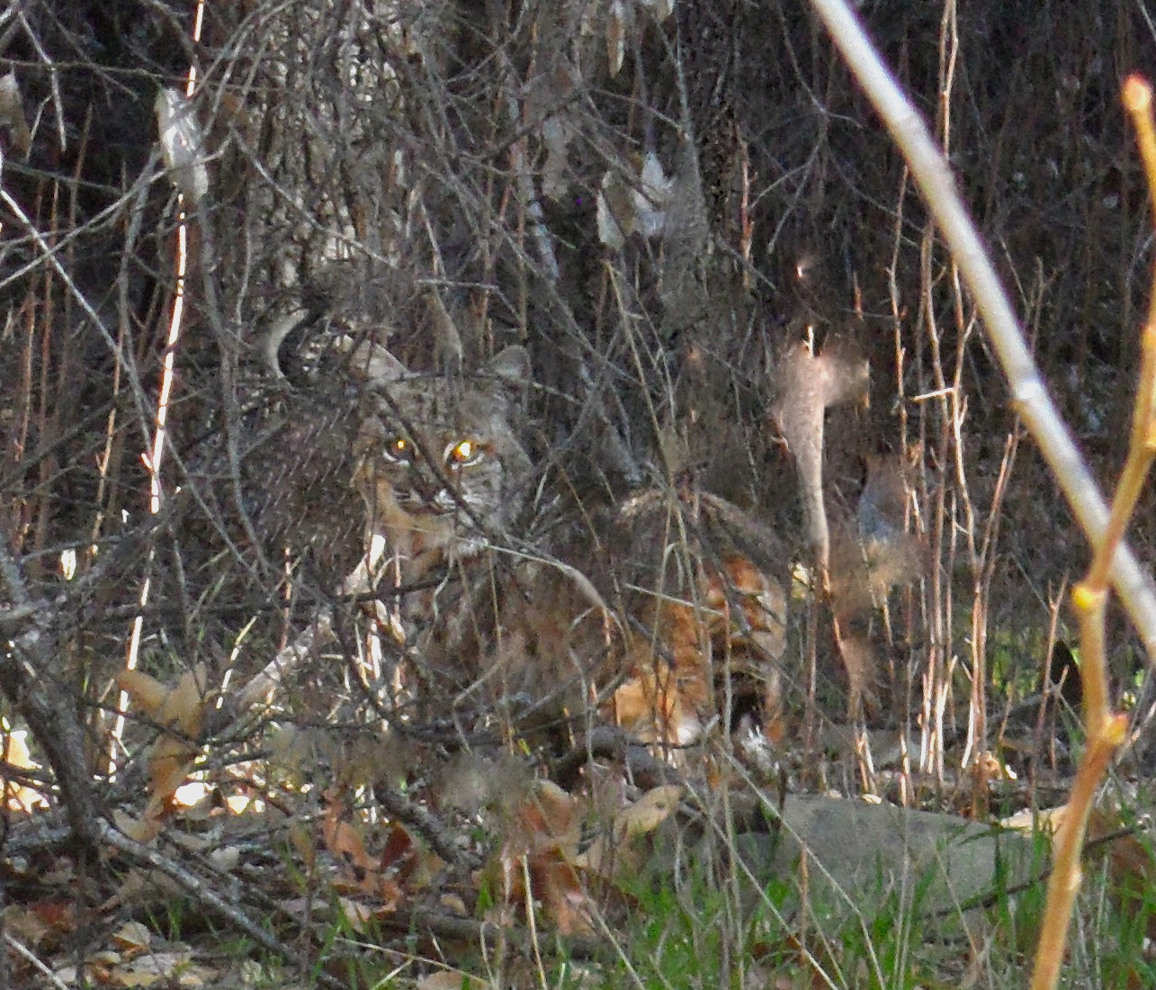
In the tangled thicket about 25 feet away, I spot a feline creature, not big enough to be a mountain lion, and it is observing me. This is either a young bobcat or, more likely, a reclusive ringtail cat (Bassariscus astutus). Note the large colored tail on the right. The ringtail cat is actually a type of raccoon. We maintain a pleasant standoff for a few minutes until Bassariscus astutus walks off sedately, and I take a dozen digital photographs, but even the best one (shown here) isn’t terribly clear.
Completing the leisurely return for a hiking total of 8.5 mostly level miles, I finally encounter the only other humans I see all day. Two happy fathers, each with son in tow (about 8 years old), heading to Potrero Camp for a single overnight, an ideal introduction to wilderness camping for young boys or girls. Years ago I backpacked with my 3-year-old son to the Double Meadow free camp, and we enjoyed three days of unalloyed bliss, simply cruising around looking for stuff and splashing in Manzana Creek’s immaculate water. These experiences are vital for humans to enjoy, especially children.
Resources
I used Bryan Conant’s San Rafael Wilderness Map, 2009 edition, obtainable for $8.95 at bryanconant.com (the 2003 edition also works) and compared it with the United States Geological Survey 7.5 min. series topo map Bald Mountain (40 ft. intervals). To view a clear map showing the San Rafael Wilderness in relation to Santa Barbara County, go to San Rafael Wilderness in Wikipedia.


