
CA Coastal Trail Finds Route Along Gaviota
Planning Commission Sides with County Staff Recommendations

The Santa Barbara County Planning Commission took on one of the thorniest issues facing them in reviewing the Initial Draft of the Gaviota Coast Plan: where to site the CA Coastal Trail (CCT). County Long Range Planners Brian Tetley and David Lackie laid out the options facing the commissioners, described as “dueling plans,” with Plan A depicting GavPac proposals for the alignment of the CCT and Plan B reflecting recommendations from county staff.
GavPac’s Plan A depicted a coastal route more closely aligned with the freeway in some places and called for the addition of a trails overlay at Dos Pueblos Ranch and along the coastal strand from Refugio to Gaviota State Park. On the other side was county staff’s Plan B recommendation that laid out a more specific alignment for the Coastal Trail, in most cases with routing along the bluff top favored by trails and environmental groups.
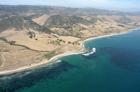
The trail issues along the Gaviota Coast are particularly difficult. From the Bacara Resort west to El Capitán, a stretch of the coast dominated by a wide coastal plain, vertical bluff tops, private holdings, and Union Pacific Railroad running through it, there is little middle ground. A freeway route minimizes impacts on the private ranches but would leave the Coastal Trail far from the “sights, smells, and sounds of the ocean,” as envisioned by the state when it passed Proposition 20 in 1972.
A route along the coastal bluffs as proposed by Long Range Planning staff would meet such a goal but has strong opposition among the ranching community and other Gaviota landholders. “Staff felt it was imperative to show an actual coastal alignment along the bluff top,” Tetley explained, “to facilitate long-range planning and develop a plan that could lead to adoption.”
“What does it mean to place a line on a map?” Commission Chair Joan Hartman, who represents District 3, asked staff. Tetley responded by saying, “The intention from staff was to provide a long-term vision for the Coastal Trail, and we felt we needed to put it on the map to actualize that vision.” He added, “It is very difficult to plan through the development process if you don’t have a vision of where the CCT should go. We felt it would be very helpful to have a planning framework in place as projects come in.”
“We chose what we thought was the best location for the CCT,” added Assistant Director for Santa Barbara County Planning and Development Dianne Black, “but not necessarily the one that would be the easiest to exact. Lines on the map have value whether they are incorporated into a project or not. Having the line provides for future opportunities to expand the trails network should they come up.”
Comments from a number of those who spoke during the public-comment period echoed this challenge. Chair of GavPav, Kim Kimbell, characterized the process as a fundamental and philosophical one. “Is the plan designed to be aspirational or practical?” he questioned. “How much of what is currently on the [Parks, Recreation and Trails] Map has been realized in the past 30 years? GavPac’s approach has been a practical one, to focus on what has a realistic chance of getting done rather than putting together a wish list that sits on a map and never gets achieved.”
Susan Petrovich, representing both the Santa Barbara Cattleman’s Association and Las Varas Ranch, argued strenuously in support of the GavPac proposal to route the CCT north of the freeway, saying it “honors and preserves the current agricultural operations and protects sensitive resources.”
“Gaviota Coast owners don’t support trails,” Petrovich added, “and I don’t think the law supports them either.”
The sharpest comments of the day may have come from superintendent of the Channel Coast District of California State Parks, Rich Rozelle, who objected to staff’s placement of the lines on the map. While many of the issues relating to siting the CCT on the eastern part of the Gaviota Coast through private holdings don’t apply west of El Capitan since State Parks owns a large part of the coastal bluff tops, geography plays a huge role in the options available there.
Describing the process of trying to locate the trail along the narrow bluff top shelf as “threading the needle,” staff nevertheless recommended a bluff-top route that would parallel the railroad on the south side of Highway 101. “I’m concerned with this approach,” Rozelle commented. “We need a constrains analysis to determine where we can and can’t place a trail before we begin putting lines on the map.”
Noting that the local state parks’ General Plan hasn’t been updated since the 1970s, Rozelle said he supported what he called a “corridor approach” rather than specific routing for the CCT. “Please embrace the fact that lines on a map are not appropriate on state-park lands. Take a step back, and look at putting a colored swath along the corridor.”
Others supported the staff recommendations. Otis Calef, President of the Santa Barbara Trails Council, noted that “change is coming” in the form of development projects at a number of the private holdings and that the siting of the CCT in the Gaviota Coastal Plan will be critical to where the trail will be located as these projects move ahead. Jim Childress, Chair of the Santa Barbara Group of the Sierra Club, urged the Commission to take in the interests of the broader community rather than just a handful of property owners in locating the CCT.
After breaking for lunch, many of those in the planning room speculated about how the Planning Commission would come down on the different plans. The deliberations after lunch began on a more philosophical note with 4th District Commissioner Larry Ferini noting that the narrative was as important as the lines on the map because it sets the tone, reflects what the PRT element is, and shows how it should be used. “There’s an inherent dilemma in working to create a regional trails network while at the same time respecting private property rights,” Ferini noted.
Not too long after that, the discussion began to heat up as 5th District Commissioner Daniel Blough suggested the plan take on all of the proposed trails for review using the swath approach described by Parks Director Rozelle earlier in the morning. “I’d like to see an overlay that includes everything suggested by both sides,” Blough suggested. “I don’t think it is appropriate to try and figure out an exact route today.”
“How do you evaluate a swath?” questioned Commissioner Brown. “You need a proposal and alternatives.” Then Commissioner Ferini chipped in, “We need to be developing a plan that will get trails established soon; the perfect plan may never get us there.”
In a conciliatory gesture, Commissioner Blough recognized the preference for the trail to be as close to the bluff as feasible but wondered if other concerns might make locations other than the bluff top the preferred route in places. “I’d still like the overlay to go from the high-tide line to the north side of the freeway so we’re sure all of the possibilities are covered,” he added.
“There is a lot of merit to what Commissioner Blough is proposing,” replied 1st District Commissioner Michael Cooney, “but it may not be appropriate for what we need to accomplish. Are we doing our job if we go that broad?”
“I just want to make sure that if we go for a route along the bluff top that it won’t preclude other options if they turn out to be more feasible,” Blough countered, mentioning a number of other issues that could make routes other than the bluff top more preferable.
“Let’s get back to the policies and see what we can agree upon,” Commissioner Cooney suggested. “We could spend hours talking about the lines on the map.”
Eventually, discussion of the Recreation policies turned out to take much less time than it appeared it would, leading the Commissioners to turn back to the GavPac and staff trail alignment proposals. Quickly agreeing to approve the north-side trail alignments, they turned to the more sticky issues relating to the CCT siting.
Commissioner Blough argued for the swatch approach one more time. “I need more staff input before moving ahead with specific trail locations,” he continued. “I’d love to study it all.” Commissioner Hartman objected, saying, “An overlay isn’t specific enough to be studied as a part of an EIR.”
“Let’s study both the Staff and GavPac proposals,” Blough countered.
Then Assistant Director of Planning and Development Dianne Black chipped in, noting that a project description was needed for the environmental review. “If we adopt the staff proposal for Figure 4-5B, what would the project description be?” Commissioner Cooney asked. “The primary route,” Black responded.
“Would that mean the GavPac route recommendation wouldn’t be studied?” Blough asked back. “No,” Black replied, “the staff recommendation includes the GavPac routes and would be studied as well.” “Good,” added Commissioner Cooney. “We really need to know if the bluff-top route is viable, and we won’t if we don’t support the Staff’s recommendation.”
With that, the Commissioners agreed to adopt the staff recommendations with some slight revisions, including study of a possible route north of the freeway west of Refugio Beach to the Mariposa Reina overpass. A very long day had finally come to a close.
Next up: Land Use issues on July 16 at the Planning Commission Hearing Room with a follow up meeting scheduled for July 30. For more information about the Gaviota Community Plan, go to the Long Range Planning website. Chapters of the Initial Draft can be downloaded there, including the detailed maps for both the GavPac and staff proposals.


