

Sometimes the best places are those you discover accidentally. Eureka Dunes, is most definitely one of those.

On my first trip well off the beaten path at Death Valley, I did most everything they tell you not to: on the way in from the Lone Pine area, I decided to head off on the Saline Valley Road on the spur of the moment. The Saline Valley Road a rough dirt road that leads into an almost desolate northern section of the park. I also headed in without a good map, any idea of the road conditions and no way to call out if a problem arose. Not exactly a prescription for success.
But the adventurous side of me prevailed over the more prudent one. The idea of coming in to Death Valley, and specifically a spot called the Race Track I’d always wanted to visit, via a route akin to what the pioneer miners might have used. I couldn’t resist the urge to head off into the unknown to see what I could find.
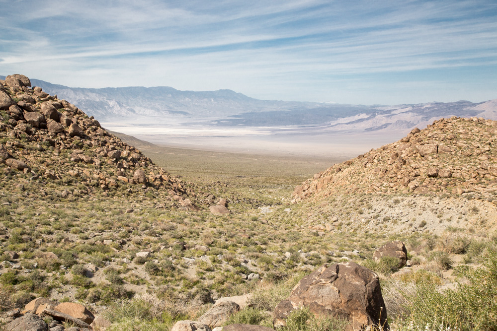
At a crucial turn, instead of continuing ahead on the road that would have taken me to the Race Track, I took what I thought was a shorter route down into what looked like a beautiful, open valley area from high above. A few hours of bumpy road that turned into bone-jarring washboard at times, I realized I’d missed the Race Track but found another area that was just as incredible.
Saline Valley by Mistake
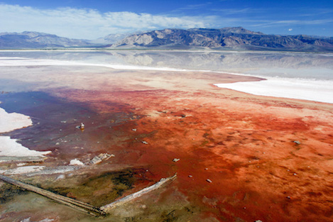
The Saline Valley is a beautiful valley that stretches for about 30 miles along the edge of one of the area’s many ancient lake beds. Usually bone dry, on this trip the lake was filled with water, though more-than-likely not much over a foot or two deep. The color was an intense red, scary actually, because the mineral content and possibly some type of algae growth made the lake almost unreal. The trip through the valley took almost two hours and the closest I came to seeing another soul turned out to be two China Lake jets screaming by me not more than 100 feet off the lake bed. Pretty exciting but at the same time I came to the realization that I didn’t have a clue where I really was.
I knew I needed to make a choice. Turning back meant admitting I’d made a big mistake. Continuing ahead could be disastrous but there was the lure of discovering something even more incredible over the next ridge. Before long I began to gain elevation, finding myself in the midst of a thick pine forest and on what appeared to be a more well-used section of road. Then around a bend I found myself staring at an incredibly welcome sight. Asphalt! After 78 miles of dirt road I couldn’t be happier to get to a place where I actually knew where I was.
The highway sign pointing left noted that is was 25 miles to Big PIne. Along that route was the turnoff to Westguard Pass and the Bristlecone Pines, where I’d been many times before. To the right the sign pointed the way to Death Valley. It wasn’t the way I’d planned on getting there, but a way in nevertheless. To my dispmay, the ten miles of the smooth asphalt highway ended abruptly. No gradual transition from pavement to dirt. One moment I was crusing along at 60mph on new asphalt and the next I was on washboard again, bumping my way along at 20mph.
Discovering Eureka Dunes
As I got to the low point in a narrow valley I spotted a side road on the right leading into a set of sand dunes that looked worth exploring. Eureka Dunes, the sign said, ten miles to the south of me. I’d never heard of the dunes but they looked really cool from the distance. The road in, however wasn’t — ten miles of some of the worst washboard I’d ever driven but the closer I got the more incredible the dunes seemed to be.
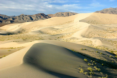
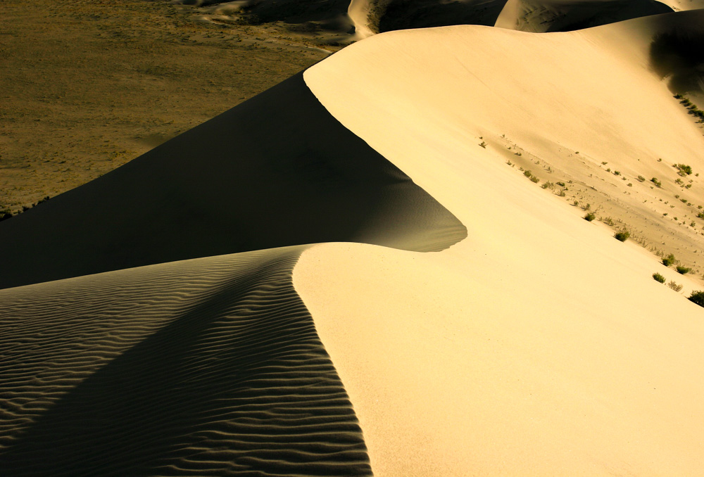
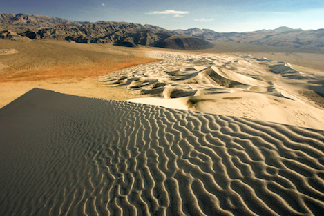
After the interminable drive to them I found myself at a small circular parking area with enough camping spots and tables for 5-6 parties and an outhouse not too far away. And also a gigantic set of sand dunes looming almost 800′ overhead and stretching halfway across the valley that I couldn’t wait to explore.
With only a little more than an hour of sun left, I quickly made my way for a few hundred yards to the first of the dunes. The wind was blowing lightly and there were no footprints, which was perfect. From the parking area you can follow several intersecting ridgelines that lead up to the crest of the dunes — very beautiful with ripples in the sand and the sharp edges of the dunes leading the way up, but ever so difficult to climb given the softness of the sand. What a perfect way to end an adventure that I never could have planned, walking the edge of the upper dune as the sun set over the mountains.
Visiting the Dunes
I try to stop by the dunes any time I visit Death Valley now. The easiest way in is to follow Highway 395 to Big Pine and then head east on Hy 168 for several miles where the road splits. Westguard Pass is to the left. Veer right onto the Death Valley/Big Pine Road and continue east for 40 miles to the turnoff to Eureka Dunes. The spur road leading to the dunes is one of the roughest washboard roads I’ve driven but the rerward at the end is well worth it. For those that would like to continue on into the park, it is 35 miles on much better dirt road to the Scotty’s Castle area.
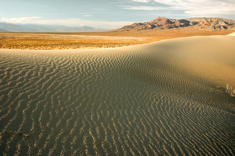
Light on the dunes is incredible during the last hour before the sun goes over the rim and the first hour in the morning light. Whether out for a walk or for serious photography, the north side of the dunes light up in the afternoon. While the temptation is to head straight up towards the highest part of the dunes, you’ll find both the walking and the picture taking best if you head out along the edge of the dunes about 2 hours before sunset and enjoy the beautiful 1.5 mile walk to the far end — or as far as you want to go. There are plenty of places to meander into the lower part of the dunes and tons of places to find the perfect picture. On the way back to your camping spot the angled light is perfect for photography and you’ll find a half mile of rolling dunes along the lower slopes of the highest ridge.
Or for those who just love walking, a trip around the base of the entire dunes may be the perfect hike. You’ll need a half day and at least four miles of hiking to make it around but it is a beautiful hike, especially in the cooler months when the midday heat isn’t out.
Morning Light
Getting the right picts in the morning is far more challenging because you really need to get up at the 6am hour and head east around the upper end of the dunes to make sure you get to the best spots before the golden light fades away. The best spot for morning photography is about 3-4 miles along the road leading to Steele Pass. The DV backcountry map warns drivers that deep sand can be found along the road but more often than not a high clearance vehicle is all you’ll need.
Continue on the road to the point where it finally turns sharply to the left, uphill and away from the dunes. While the highest part of the dunes is off to your right, the best spots for picture taking are to the left where the dunes are lower in height and there are hundreds of smaller rolling dunes that create amazing patterns in the sand. That’s the good news; the bad is that to reach them you’ll need to hike in about a half mile across a wide expanse of dry lake bottom type hard pan, which is why getting up early and on the go is a must. You might even consider setting up camp on this side of the dunes to make it easy to start out at first light.
Once you reach the first of the low dunes and began working your way in and out of the lower ones you’ll be amazed at how quickly time flies by and how difficult it will be to peel yourself away.
4•1•1
For more detailed information about the Eureka Dunes, check the SB Outdoors Blog or the Santa Barbara Outdoors (SBO) website. SBO is the place to go for information about where to hike, bike, ride or walk in Santa Barbara County.


