
‘And it never failed that during the dry years the people forgot about the rich years, and during the wet years they lost all memory of the dry years. It was always that way.’ —John Steinbeck, East of Eden
If we had an inch of rain for every sensationalistic headline written about this year’s El Niño, the drought would already be over. But hype is cheap, and rain, unfortunately, is still rare. So what of this much ballyhooed weather phenomenon? Will soaking storms return to the South Coast, or are we once again fated for a winter of drizzle? With our reservoirs nearing their lowest levels ever, this question is critical to life itself in Santa Barbara. Take a look around you — none of it happens without water.
The Phenomenon Defined
By now you’ve likely heard the showy figures being tossed around by the traditionally reserved National Oceanic and Atmospheric Administration (NOAA). In its mid-November El Niño update, the federal agency declared with 95 percent probability that the currently unfolding El Niño will be “very strong” through this upcoming winter. More to the point, NOAA has ventured with 60 percent likelihood that this will translate into “greater than average” rainfall for Southern California.
It may not seem like much, but that 60 percent claim is a big, big number when it comes to such things. As Tom Di Liberto, a meteorologist with NOAA’s Climate Prediction Center, told me last week, “This is a strong event, and it is still strengthening. We don’t see this often. So far, month in and month out, it just keeps growing.”
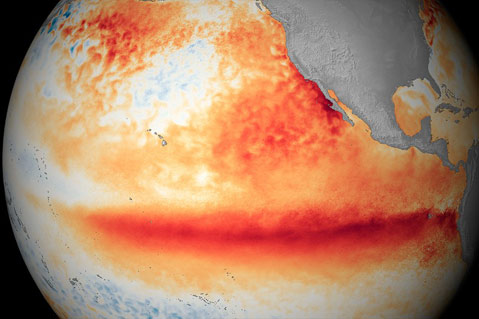
Sounds good, right? But what does it actually mean? Well, first understand that the term El Niño describes a variety of weather factors occurring in concert with one another. In normal years, prevailing Pacific Ocean winds blow west from the coast of South America, moving warm, near-shore surface water out to sea and allowing colder, deeper waters to rise up and replace it. The Pacific plays a paramount role in the world’s weather patterns, and this conveyor-belt-like dance of wind and water is a big part of that.
However, during El Niño years, these equatorial winds significantly slow and, in extreme cases (such as this year), even begin to blow in the opposite direction on occasion. This results in the warm water staying put, continuing to heat, and sometimes being reinforced by even warmer waters to the west.
Waters need to average at least a 0.5 degree Celsius increase over a three-month period to earn the El Niño label. Right now, they are running as much as 3.4°C above average in some places. Similar readings have been approached only once in the last 65 years, during the infamously wet El Niño winter of 1997-98.
“When it is all said and done, we expect this to be a top three [El Niño event],” summed up Di Liberto. “It could very well be the strongest one ever recorded.”
Pregnant with the Promise of Rain
In and of itself, El Niño does not equal rain. In fact, for places like southern Africa and Central America, it often spells drought. That being said, a persistent presence of warm eastern Pacific water changes the weather flow for North America in such a way that rainstorms, though not necessarily bigger, are more frequent in Southern California. “Basically, El Niño makes it easier for storms to travel in a certain area over and over again,” explained Di Liberto.
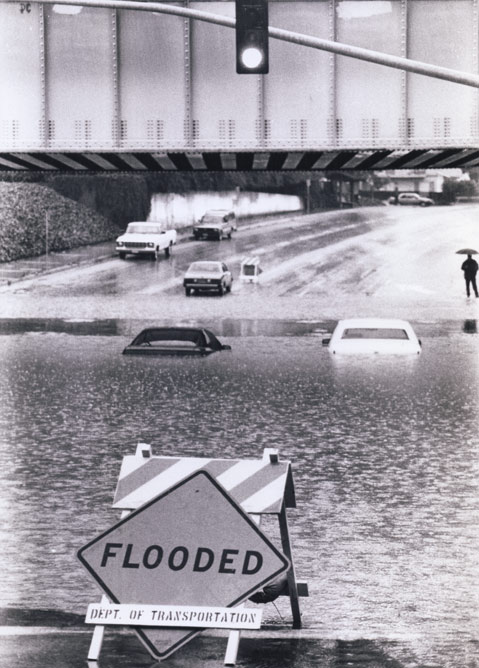
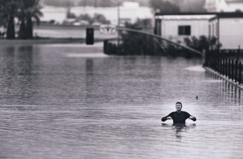
Take a look at the wettest years for any town in our county — the El Niño winters of 1997-98 and 1982-83 weigh in as either number one or number two on their respective lists. In fact, according to NOAA, there have been six “very strong” El Niños since they started tracking them in 1950, and all of those have equaled Top 10 annual rain totals for Santa Barbara and the surrounding areas. The pinnacle came in 1997-98 when just shy of 47 inches of rain fell in Santa Barbara, the most measured in 116 years, and nearly three times our annual average. In February alone of that season, Santa Barbara enjoyed six distinct rainstorms and 14 days of rain.
“What we have seen play out this summer and fall in terms of temperature rise and winds is very similar to what we saw in ’97,” said Nathan Cool, a weather and surf forecaster for Surfing Magazine and Wavecast.com. “But it is important to remember, no two El Niños are alike.”
A software engineer for three decades, Cool has been bringing those skills to bear in the weather world for the past 20, often making his own models and running numbers based off NOAA’s raw data. “I would be quite surprised at this point if we have another dry winter here in Southern California. There is really nothing working against us on the charts at this time,” offered Cool before adding knowingly, “Of course, this is an imperfect science. We still can’t predict the weather a week out let alone a few months out, so there is no such thing as a guarantee. But I would say this is the next best thing.”
Hedging Bets?
The summer-esque days of October assured us that even if November and December prove historically cold, 2015 will go down as Earth’s hottest year on record. This, of course, comes after 2014 earned the same distinction. Here in Southern California, we are wrapping up our fourth year of drought and our four driest consecutive years on record, a fact that has Santa Barbara County’s lynchpin reservoir — Lake Cachuma — at 15.4 percent of capacity, just barely above its all-time low in the early 1990s. While levels are not historically low based on numbers (e.g., water heights along the sides of the reservoirs), when you consider sediment infill and vastly reduced consumption habits, current readings are markedly lower in actuality than any time before.
“Unfortunately, no one El Niño will end our drought.” explained Jon Frye, Santa Barbara County’s Flood Control and Water Management engineering manager. “There really isn’t one magic number for rainfall this winter that would get us out of it. Even the wettest winter ever wouldn’t do that.”
That being said, the expectations are high and, by all accounts, rightfully so. Even Frye and his team, informed by intel from the National Weather Service and NOAA, have been lobbying property owners since July to consider flood insurance and prepping couty infrastructure for the worst. So what exactly can we expect?
“Sadly, historical patterns are no guarantee for what we can expect in the future,” said John Lindsey, a former U.S. Navy marine meteorologist and longtime weather forecaster based out of Los Osos. According to Lindsey and others, there are a variety of variables at play that may work to enhance or derail our clear and present El Niño. After all, it was just last year at this time when we heard bullish forecasts for an El Niño winter only to have it fall apart after a wetter than normal December.
One such factor is known as “The Blob,” a weird region of warm water in and around the Gulf of Alaska. This meandering mass has been more or less a constant in recent years, throwing off seasonal weather swings and helping support a “ridiculously resilient ridge” of high pressure to the south and east. It is this ridge that has worked as a blocker of sorts for would-be rainmakers trying to find their way down the coast, and there has been much speculation about what would happen should a robust El Niño square off with a firmly entrenched Blob.
Perhaps, as some of the fearmongering has gone, the ridge would prevent a proper El Niño from delivering snow and rain. However, to hear Lindsey tell it, that fear is no longer necessary. “That blob is officially gone,” said Lindsey. “The [water] cooling has been quite remarkable in that region as of late.” Its absence, or at least steady retreat, is evidenced by the recent run of more traditional fall weather along the Central Coast, complete with Santa Ana winds, near-weekly weather fronts skirting our region, and early season snow in the Sierras.
The ‘Christ Child’ Cometh
With sea surface readings expected to peak near the equator sometime in December, Lindsey, echoing similar sentiments from NOAA forecasters, thinks we will start to see the effects of El Niño shortly after its namesake holiday. (El Niño is actually in reference to the “Christ Child” because its associated warm waters in South America typically come around Christmas). “I think we will see the southern branch of the polar jet [stream] drop down by the early days of January,” speculated Lindsey, “and the storms shouldn’t be too far behind that.”
Interestingly enough, Lindsey, who worked closely with the late weather wizard Rea Strange, recalls a similar “dry” period in the lead-up to the 1997-98 El Niño when everybody, himself included, thought they had overshot their mark in forecasting a big winter. “It was January, and we were still below normal,” he said. “And then it happened — the jet dropped, and we had almost a year’s worth of rain in the month of February alone, followed by a very wet March, as well.”
But it isn’t so much what he sees on the charts right now that has Lindsey thinking we are in for a doozy this winter. It is more a simple matter of history. Pointing to a database at Cal Poly that goes back to 1870, Lindsey explained, “We have never before had four consecutive years of drought in this part of the world, at least in modern times. Based on that, my gut is telling me it is going to be a wet one.
“I mean, if we do have a fifth year, it will signal a fundamental paradigm change,” he said. “All the rules about what is possible and what is impossible would have to be rewritten.”


