
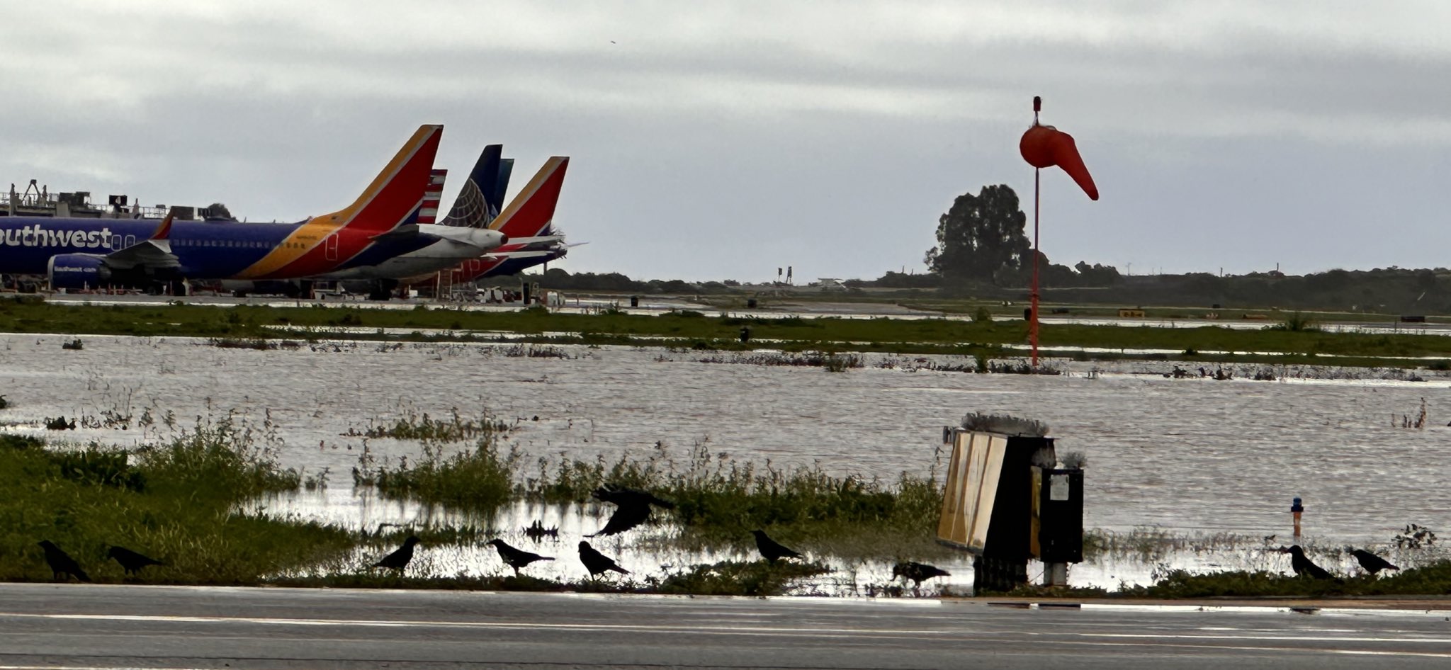
This past February, the Santa Barbara Airport closed twice due to flooding from incessant rainstorms. The year before it closed in January when powerful storms driven by atmospheric rivers of rain dropped more than 10 inches along the coast and 33 inches in the mountains. Barely 15 feet above sea level — the Pacific Ocean is just a few hundred yards away — the airport is bordered by the Goleta Slough and three creek systems. Given its vulnerability to sea level rise, the airport is currently planning for the effects an increase of up to 6.6 feet, and the public is invited to take part.
The 950 acres that contain the airport are no stranger to flooding. In fact, the neighboring Goleta Slough was born out of a winter that brought Biblical levels of rainfall. What had been a bay deep enough to draft small ships on Christmas Eve in 1861 came to be filled with the gravel and sand that swept from the mountains during a near-continuous rainstorm that lasted until February 5, 1862. Historians called it the Noachian deluge, Larry Gurrola wrote in a report titled “Fire, Flood, and Landslide Dam History” (2022). The storms dropped 50 inches of rain in Santa Barbara, clearing the soil out of the orchards, Gurrola wrote. Flooding from mountain creeks “permanently changed the 36 landscape and creek channel locations of Santa Barbara County.”
This past March, a study of core samples from the Carrizo Plain showed that even larger episodes of flooding had occurred sometime between 1470 and 1640, and again at some point between 1740 and 1800. Though the 1862 floods were large enough to create an inland sea 300 miles long in the Central Valley, the study published in the Journal of Paleolimnology did not find sediment from those floods in the core sample. As reported by the Los Angeles Times in June, this suggested that 1862 was a significantly smaller flood than the other two events.

[Click to expand] A map of Santa Barbara Airport and surrounding creeks from the airport’s sea-level rise adaptation plan. | Credit: Courtesy
The waterways around Santa Barbara Airport have all been altered to reduce flood risks, but the pooling of water on the runways has shut the airport periodically since it started commercial flights in 1936, most severely in 1969 and 1995, when the entire airport flooded, not just the runways. The Climate Change Vulnerability Assessment prepared by the airport underlines the effects of climate change in causing three closures in the past two years.
The stakes are high. Any day-long closure affects 21 to 34 flights and costs the airport around $120,000 in revenue a day. Add to that any damage or debris; for late February 2024, that totaled $879,000. If 2.5 to 3.3 feet of ocean rise occurs, the report envisions the costs from flooding would cause operations to cease as early as 2068, or as late as 2108.
In preparation for the upcoming review, the airport’s Climate Change Vulnerability Assessment is part one of a three-phase endeavor to analyze the area, airport operations, and flood protection, and come up with a plan by 2026. It also looks at Isla Vista and Old Town Goleta and the effects of flooding there, on airport equipment, sewers, storm drains, and more.
The next section of the study would examine methods to protect the airport against flooding, accommodate floods, or implement retreat strategies that allow the airport to keep functioning. The range of strategies go from “nature based” to “hard-grey” structures, and the next phase includes costs and points at which action must be taken. The final phase is an update of city ordinances and plans to reflect the outcomes of the Climate Adaptation Plan, which is linked at this page.
An open house for the Climate Adaptation Plan takes place on Tuesday, January 7, 2025, 6-7:30 p.m., at Direct Relief (6100 Wallace Becknell Rd.). The city Airport Commission takes up the topic on Wednesday, January 15, 2025, 6 p.m., at the Airport Administration Office (601 Firestone Rd.) Comment can also be submitted by email before January 16, 2025, at SBA_CAP@SantaBarbaraCA.gov.
Related Posts


Premier Events

Sun, Aug 02
12:00 PM
Santa Barbara
Brass @ the Bandshell: All-American Fanfare

Sun, Aug 02
6:00 PM
Santa Barbara
Hawaiian Music Sunset Cruise

Mon, Aug 03
11:00 AM
Santa Barbara
SAD (survival amongst distress)

Tue, Aug 04
12:00 PM
Santa Barbara
Fiesta at Paseo Nuevo

Tue, Aug 04
6:00 PM
Santa Barbara
Chaucer’s Book Talk & Signing: Mario T. García

Tue, Aug 04
6:30 PM
Santa Barbara
Community Conversation: Degrowth and Climate Justice: A Community Q&A

Wed, Aug 05
11:00 AM
Lompoc
County Health’s 2026 Back to School Health Fairs – Lompoc

Wed, Aug 05
3:00 PM
Santa Barbara
Fiesta at Dusk

Thu, Aug 06
11:00 AM
Santa Barbara
County Health’s 2026 Back to School Health Fairs – S.B.

Thu, Aug 06
6:00 PM
Santa Barbara
Fiesta Rooftop Party – Kimpton Canary
Sun, Aug 02 12:00 PM
Santa Barbara
Brass @ the Bandshell: All-American Fanfare
Sun, Aug 02 6:00 PM
Santa Barbara
Hawaiian Music Sunset Cruise
Mon, Aug 03 11:00 AM
Santa Barbara
SAD (survival amongst distress)
Tue, Aug 04 12:00 PM
Santa Barbara
Fiesta at Paseo Nuevo
Tue, Aug 04 6:00 PM
Santa Barbara
Chaucer’s Book Talk & Signing: Mario T. García
Tue, Aug 04 6:30 PM
Santa Barbara
Community Conversation: Degrowth and Climate Justice: A Community Q&A
Wed, Aug 05 11:00 AM
Lompoc
County Health’s 2026 Back to School Health Fairs – Lompoc
Wed, Aug 05 3:00 PM
Santa Barbara
Fiesta at Dusk
Thu, Aug 06 11:00 AM
Santa Barbara
County Health’s 2026 Back to School Health Fairs – S.B.
Thu, Aug 06 6:00 PM
Santa Barbara

You must be logged in to post a comment.