
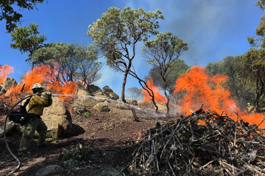
Los Padres National Forest staff are set to clear 33,023 acres of forest, including in Santa Barbara County, in the name of reducing wildfire risks.
The service’s Wildfire Risk Reduction Project was recently stamped with a finding of “no significant impacts” to the forest environment, four years after the process began. It involves the clearing, burning, and grazing of vegetation to reduce fuel and improve “forest health.”
The initial planning work will begin immediately, though no vegetation will be cleared for some time, the Forest Service announced on October 20.
A Long Road to Reduce Wildfire Risk
It’s been a four-year-long tug of war with the public over the extent of the project. Originally, it proposed vegetation treatments (thinning, chipping, grinding, mowing, etc.) across 235,000 acres of the forest.
Community members and environmental groups, mainly Los Padres ForestWatch, balked at the initial acreage; it was the largest vegetation removal project ever proposed in the forest.
Concerns swirled around the creatures that rely on the forest’s unique, diverse habitat. Los Padres hosts many ecosystems within its two million acres, including chaparral, evergreen forests, oak woodlands, redwood forests, grasslands, and riparian habitat.
The initial project proposal was a “one-size-fits-all” approach that did not jibe with the makeup of Los Padres, ForestWatch argued. It would have sacrificed much of the forest’s natural resources for a project that, when all was said and done, would have been more successful at damaging the landscape than keeping wildfire at bay.
However, after the service heard and incorporated feedback from the community, the acreage shrunk.
First, it was reduced to 90,000 acres. Now, it’s 33,000.
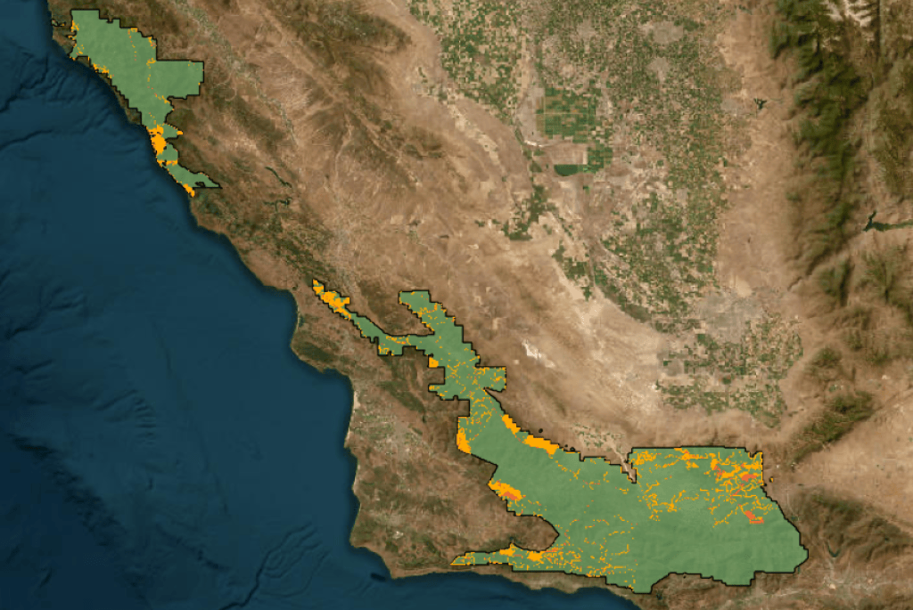
The Forest Service was not going to scrap the project altogether. The service has a duty to protect communities and the forest as a whole, said Kyle Kinports, a district ranger and the lead planner on the project.
Service officials said the plan is to create defensible space around homes, such as in Painted Cave, and open up fuel breaks for firefighters. Fuel breaks slow a fire’s progression and give personnel a frontline from which they can safely and effectively fight the flames.
Wildfires are becoming ever more frequent and severe across California as the state heats up and dries out. Just this August, Los Padres burned in two wildfires, the Timber and Plaskett fires in Monterey County, which scorched a combined 50,000 acres. So, it’s not a matter of if, but when, the service argues.
Fires have wiped out entire strands of forest, and they’re not regenerating, Kinports said.
There’s a lot of initiative from the state “to tackle the wildfire problem,” added Seth Mitchell, the service’s deputy forest fire chief.
Along with creating defensible space for homeowners and fuel breaks for firefighters, the service will conduct “forest health” projects to restore areas overrun with invasive vegetation that is highly flammable.
It involves treating invasive grasses with methods such as grazing, and partnering with UC Santa Barbara to plant “several pounds” of seeds of native plants that are less ignitable than their non-native counterparts.
On the ground, folks might see goats and sheep in some project areas, and in others, heavy equipment to chew up vegetation or officials setting controlled fires.
Mitchell said these strategies are, in part, to mimic the role fire used to play in those landscapes before suppression efforts — reducing flammable undergrowth in old-growth forests, for example. “We are trying to make the landscape a little bit more fire resilient,” he said.
He said work will avoid crucial habitat for sensitive species, such as red-legged frogs, condors, and California spotted owls. He said the service will also work with native tribes to protect cultural heritage sites.
Forest Service officials emphasized that the forest’s core wilderness areas will remain untouched, instead focusing on the perimeter near private lands. They also clarified that no new fuel breaks will be created for the project — rather, existing fuel breaks will be re-cleared.
Still, conservationists argue the project could be downsized further.
Fire isn’t a disaster for the forest, said Benjamin Pitterle, director of advocacy and field operations for ForestWatch. Plants in Los Padres are adapted to fire.
“Disaster is when communities burn,” Pitterle said.
Pitterle’s argument was that the service had a knee-jerk reaction to the risk of wildfire, proposing mass-clearing of forest without thoughtful consideration of the environment.
Pitterle said ForestWatch was instrumental in making the project not only smaller but also “smarter.”
Pitterle explained that his organization supports the need to protect communities but wanted it done in a way that does not disturb habitat while employing more “rhyme and reason” to proposed treatment areas.
ForestWatch, in collaboration with community groups and elected officials, drew up its own map and project alternative, supporting strategically located treatments near communities, infrastructure, roads, and existing fuel breaks.
Some formerly proposed fuel breaks “were staggering in width,” Pitterle said, and did not make much sense in terms of ongoing maintenance — some were on steep slopes that would be hard to access, for example.
“The Camino Cielo ridgeline makes a lot more sense to deploy firefighters than somewhere 20 miles out in the middle of nowhere, in the center of the forest,” Pitterle said. “None of this stuff was meant to stop fires automatically. All of it requires coordinated fire suppression efforts.”
Pitterle lamented that the project’s emergency authorization — designated in July 2026 — allowed the service to skip a standard objection period that would have allowed for more community feedback at this point in the process.
However, the Forest Service ultimately incorporated much of the public’s suggestions, he said.
Kinports said that when the project was initially proposed, it was a “dramatic shift” from the size and scope the service usually undertakes, intending to provide opportunities to treat different areas of forest as needed. But they quickly realized that it was “just too much, too big,” so they “systematically scaled it back.”
“We really were intent on trimming it down to something that made sense for us … that also considered the feedback that we received from the public,” he said.
Pitterle said, “It’s absolutely better.” However, he added, “It’s definitely not perfect. There’s still work in sensitive and remote places.”
‘Still a Big Project’
The plan still spans much of the forest and includes hundreds of miles of fuel breaks, Pitterle said. He said ForestWatch will be involved in ensuring implementation follows the plan’s mitigation measures, such as for the forest’s unique chaparral habitat.
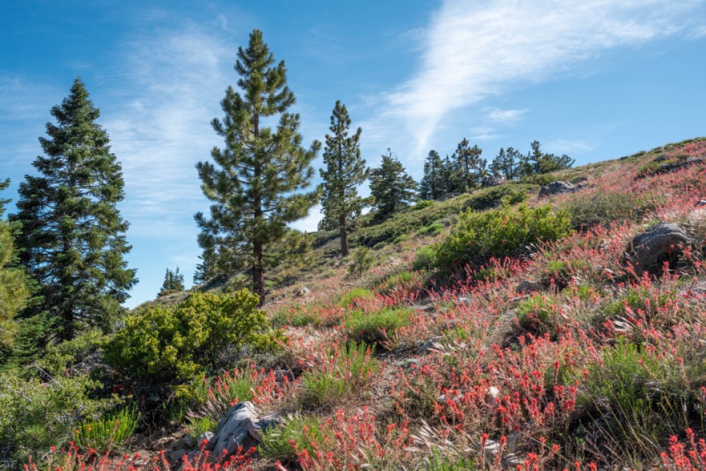
Chaparral — a community of dense, woody evergreen shrubs and trees, such as manzanita — covers more than 70 percent of the forest, providing habitat for wildlife and stabilizing slopes. It is only found in a few regions around the world. It’s got a bad rap for being shrubby and acting as fuel for wildfires, Pitterle said, but it’s crucial and less ignitable than non-native grasses.
Chaparral is under threat throughout Southern California because of development and too-frequent fire. Repeated clearings can nip chaparral in the bud and allow non-native, flammable grasses to move in, Pitterle said, which may cause lasting damage to habitat.
One fuel break is proposed along the ridge near Gaviota, one of only two places where Refugio manzanita grows. Pitterle worries that it will destroy the rare plant’s habitat.
“Fuel breaks are known to become vectors for invasive grasses, and we don’t have any way of reversing that,” he added. “It’s literally forever.”
Fuel breaks can help in some situations, he said, but can be overwhelmed by wind-driven fires. Treatment then, he argued, should be strategic to reduce disturbance to chaparral.
Kinports with the Forest Service said the service will work with botanists to minimize those impacts. He added that the work needs to “address too frequent fire in chaparral and too little fire in conifer areas,” where fires once spread through the area every 12 years.
Historically, the blazes would clear out understories and add more space between trees. But with a lack of fire due to suppression actions, the forest is seeing overgrowth, with denser tree cover more prone to severe wildfire and insect infestations.
“That puts forested areas at risk of wipeout, essentially,” he said, including higher mortality rates of large, old-growth trees. “That’s what we’re trying to avoid: losing the forest we have right now.”
Overall, Kinports said that many proposed treatment areas are “not pristine,” and have seen some level of impact in the past. “It’s not like we’re going out into pristine chaparral areas and conducting vegetation treatments,” he said.
Mitchell added that, “at the end of the day,” the public demands that firefighters suppress wildfires.
“And if that demand is there…that means that we will have to go in and open fuel breaks in the chaparral-dominated ecosystems,” he said. “If the mandate from the public is to fight these fires aggressively, then the public also needs to understand that we need to provide a safe working environment for firefighters.”
When and Where?
When and where the treatments start is funding dependent, Forest Service officials said. It will also depend on where the highest fire risks are, and projects will be implemented based on that criteria. One proposal, for example, is a grazing project along the Camino Cielo ridgeline.
But there is not “one big project that is breaking ground as of yet,” Mitchell said.
Eventually, the project will “be all over” the forest, Kinports said. Plans will have to align with the forest’s partners, such as CalFire and fire safe councils, while considering funding and geographic constraints, he explained. The service cannot treat everything all at once, he noted.
Some first priority areas, however, are in Santa Barbara County and San Luis Obispo. “That’s what we’re exploring at this point,” Kinports said.
Right now, the service is shifting into implementation, but it’s a 20-year project covering a lot of acreage.
“Work is not going to start tomorrow,” Kinports added.
Bigger picture
The project comes at a flashpoint for forest management nationwide. Tree diseases and invasive bugs are decimating forests across the country. Prescribed burns, including in Santa Barbara County, are increasing in frequency to control fuels, mimicking past fuels management in the region’s fire-prone landscape (fall and winter are prescribed burn seasons for the state).
Meanwhile, the Trump Administration is seeking to withdraw the Roadless Rule, which has prevented logging and roadbuilding in the nation’s national forests for 25 years — a largely unpopular pursuit.
On top of that, the Fix Our Forests Act is making its way through the legislative review process. It could exempt vegetation treatment projects of up to 10,000 acres from any environmental review.
“This project is a perfect example of why that’s a bad idea,” Pitterle said. “The reason that we have these processes and these laws is so that we can work together to find better solutions.”
Related Posts


Premier Events

Sat, Nov 21
9:00 AM
Santa Barbara
Hope as a Phenomenon of Human Nature

Sat, Nov 21
9:00 AM
Goleta
Holiday Gift Boutique in Goleta

Fri, Nov 20
11:00 AM
Santa Barbara
Santa Barbara Antique & Vintage Show

Sat, Nov 21
10:00 AM
Solvang
56th Annual Holiday Open House

Sat, Nov 21
10:00 AM
Santa Barbara
MOXI’s Seaside Sock Skating
Sat, Nov 21
11:00 AM
Santa Barbara
Santa Barbara Antique & Vintage Show

Sat, Nov 21
11:00 AM
Santa Barbara
Cassatt Reconsidered: Lecture with Mary G. Morton

Sat, Nov 21
7:30 PM
Santa Barbara
Juilliard String Quartet & Simone Dinnerstein

Sat, Nov 21
7:30 PM
Santa Barbara
Santa Barbara Blues Society Presents Teresa James and the Rhythm Tramps
Sun, Nov 22
11:00 AM
Santa Barbara
Santa Barbara Antique & Vintage Show

Sun, Nov 22
2:00 PM
Goleta
Prime Time Band Fall Concert

Sun, Nov 22
5:00 PM
Santa Barbara
Choral Evensong: Sung by the Trinity Choir
Sat, Nov 21 9:00 AM
Santa Barbara
Hope as a Phenomenon of Human Nature
Sat, Nov 21 9:00 AM
Goleta
Holiday Gift Boutique in Goleta
Fri, Nov 20 11:00 AM
Santa Barbara
Santa Barbara Antique & Vintage Show
Sat, Nov 21 10:00 AM
Solvang
56th Annual Holiday Open House
Sat, Nov 21 10:00 AM
Santa Barbara
MOXI’s Seaside Sock Skating
Sat, Nov 21 11:00 AM
Santa Barbara
Santa Barbara Antique & Vintage Show
Sat, Nov 21 11:00 AM
Santa Barbara
Cassatt Reconsidered: Lecture with Mary G. Morton
Sat, Nov 21 7:30 PM
Santa Barbara
Juilliard String Quartet & Simone Dinnerstein
Sat, Nov 21 7:30 PM
Santa Barbara
Santa Barbara Blues Society Presents Teresa James and the Rhythm Tramps
Sun, Nov 22 11:00 AM
Santa Barbara
Santa Barbara Antique & Vintage Show
Sun, Nov 22 2:00 PM
Goleta
Prime Time Band Fall Concert
Sun, Nov 22 5:00 PM
Santa Barbara


You must be logged in to post a comment.