History of the Gaviota Pass
‘The Wildest Pass I Have Yet Seen Here’ and Other Memories of Santa Barbara County’s Dramatic ‘Gate’

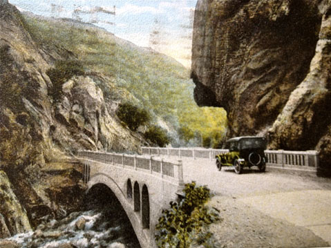
In March 1924, a woman named Theresa came through the Gaviota Pass on her way to San Francisco. With a penny stamp, she mailed a picture postcard of the scene to a Mr. and Mrs. Radka of Detroit. Ninety years later, that postcard has found its way back to Gaviota, where I am holding it in my hand. “Here are some of the mountains we have seen!” Theresa wrote, and it’s easy to understand how impressed she was. The area has changed, but its essence is immutable, and its rugged beauty endures.
A crucial gap in the coastal mountains where the highway curves inland just northwest of Santa Barbara, the Gaviota Pass came into regular use after the founding of the Santa Ynez Mission, and was almost the scene of an ambush in 1846, when Mexican forces waited on the cliffs for John C. Fremont, who was tipped off and chose the trickier San Marcos Pass to invade the coast. In the 1850s, pioneers chiseled the rock wall to widen the opening for wagons, but mud, debris, and boulders often obstructed the trail. William Brewer, who passed through in 1861 as part of a geological survey team, wrote, “This sandstone ridge is a continuous one, and has but one break, the Gaviota Pass, for a hundred miles or more. At the Gaviota a rent or fissure divides the ridge, but a few feet wide at the narrowest part and several hundred feet high. The road passes this ‘gate’ and then winds up a wild rocky canyon, the wildest pass I have yet seen here.”
Traffic grew in the 1860s as ranches developed inland and the first county road was built. Dynamite was used to widen the opening to the pass, and a wooden bridge was constructed over the creek. In 1915, the State Division of Highways took over: graveling, straightening, widening, and rerouting. A steel suspension bridge replaced the wooden span, and eventually a 190-foot reinforced concrete overpass replaced the steel bridge. There was concern about the danger posed by a large overhanging granite rock on the western side of the pass, the one resembling the head of an Indian. Fortunately, folks protested destruction of the rock, and although some safety modifications were made, most of it was retained. The Indian is still there, a distinctive sentinel on the southbound side keeping silent watch over his domain.
The highway underwent its most significant transformation in the 1950s, with its gradual conversion into a four-lane, limited-access freeway. Rather than further widening the gorge by removing massive amounts of rock from the mountainside, the Gaviota tunnel was “holed through” early in 1952 and completed in May 1953. (In one of those quirks of cinema history, it’s the tunnel Dustin Hoffman drives through in The Graduate, though we know he’s headed north rather than south as the movie suggests.) Locals still recall seeing ladders high on the rock that were supposedly left behind by surveyors; these gradually disintegrated, but they were there at least into the 1970s, when two young guys named Pete and Mark decided to climb them. “The view was great,” recalled Pete years later. “The condition of the ladder, sketchy.”