

When Jedediah Smith made his way over South Pass in 1824, having rediscovered what would become a major route over the Continental Divide. Without the intention or desire to do so, he was paving the way for the route my family would take over the Rockies in the summer of 1951. Just eight years after Smith’s discovery the first caravan composed of 110 men and 20 wagons made its way over the pass, providing a more central route for emigrants heading west and in the process creating might might have been Colorado’s first backcountry road. More than a half million would use the pass over the next forty years until the transcontinental railroad would provide a much easier way to cross.
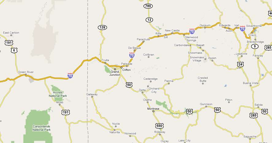
I’ve spent the night in Green River, Utah, a stone’s throw off Interstate 70 and am on my way to Denver via the small mining town of Leadville. What would have taken the wagon trains several weeks will take me less than a half day on Highway 70, assuming I don’t make any side trips.
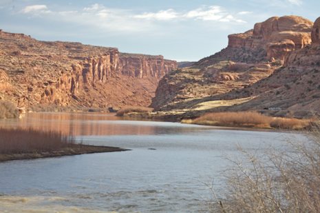
I’d rather be off on the smaller side roads making my way here and there but there really isn’t a wealth of roads out here in the desert: it’s either Highway 70 or another major route way north or south. After stopping by Sego Canyon near Thompson Springs to spend a few moments reflecting on the rock art there, I retrace my route a few miles, and head down into the Moab area.
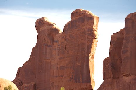
It’s hard not to spend a bit of time here. Both Arches and Canyonlands are spectacular national parks and even an hour or two spent here is worth it. This is especially a nice to time visit.There are few visitors and the winter sun sits low in the sky, making the lighting particularly nice. The walls of Park Avenue in Arches seem to glow. From Moab I make my way up the Colorado River road to Highway 70 again, set the cruise control to 70 mph, and grind up the miles.
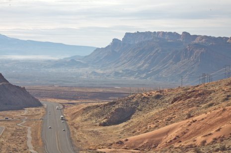
The cruise is an easy one, the drive along the deserts and plains of the western slopes of the Rockies a bit monotonous. This isn’t dramatic country, more a wide expanse of scrubby desert plants, occasional sandstone outcroppings that provide a moment of glamour and long, straight pieces of highway that seem to take forever to cross – forever, of course measured in far different time than the pioneers might have used.
About noon I cross into Colorado, move past the farming town of Fruita, skirt Grand Junction and head on to Glenwood Springs, gateway to the Rockies. What were sunny skies have given way to a silver glow. It is getting cold and there are a few wisps of icy snow blowing my way. I’m still in short pants but that may change soon. I stop in town to check out the springs, which is actually what looks like a huge swimming pool filled with what I assume is soothing warm water.
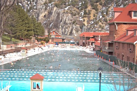
The source is a natural spring located nearby. Incredibly, 3,500,000 gallons of water percolate through fractures in the bedrock formation and into the Leadville aquifer each day at a temperature of 122° F. and into the pools at a more comfortable 104 ° F. The rate isn’t too steep – $13.00 for the day but a bit more than I’d rather pay for the short time I’d stay. Another time.
Glenwood Springs is also famous for being the point where skiers cut off Interstate 70 to head up to the Aspen ski areas. On another time when winter snow hasn’t closed Independence Pass to travel, I’d head this way up to Leadville but today there is no other choice but to continue along the interstate.
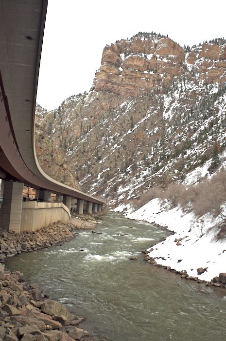
The highway east of Glenwood Springs follows a particularly scenic route, following the Colorado River up through a narrow canyon that proved somewhat difficult for engineers when they planned the construction of the interstate along it in the 1970s. The sixteen mile long canyon consists of almost sheer cliff rising on either side of the river, with barely enough room for a hiking path let alone a full-sized freeway. Environmentalists were especially concerned about the damage that might be done to the canyon. Despite suits by the Sierra Club and Coloroado Open Space Council to prevent it construction, eventually this section of Interstate 70 was started in 1984 and completed in 1992.
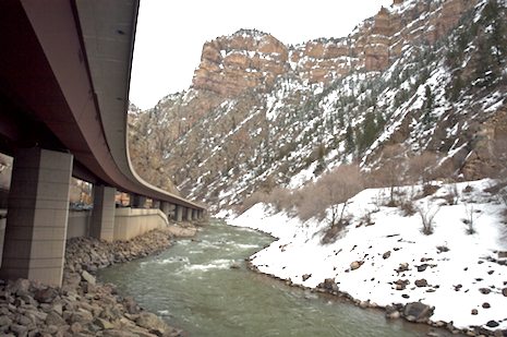
Ironically, this may be one of the most esthetically beautiful sections of highway build anywhere in the U.S. The main reason for this was because a construction method never before attempted in the U.S. known as balanced cantilever construction was used. The method works by building a bridge from above, rather than below. A bridge column is first built, and then a special crane known as a gantry is positioned atop the column. The gantry builds the bridge outward from the column using precast segments that are trucked in.
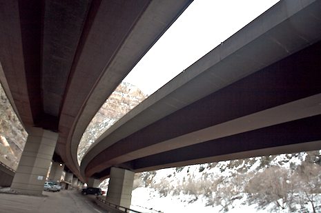
Whatever the reason, though not long in distance, it is one of the few sections of interstate I look forward to driving. I stop a few times on several of the rare off ramps that allow you to check out both the construction and the river. There’s a bonus I discover that I hadn’t seen before from above – a bike path follows the entire route through the canyon but because it is tucked under the upper deck of the highway, it’s hidden from view. It is closed now because of the snow covering it but I know I’ve got to ride this some day.
I’m not particularly a fan of the interstates, having seen the impacts in my part of Utah on the local communities when the super highways pass them by. More importantly to me, there’s a lot of America that gets lost in the shuffle, small town America that is becoming more and more hidden from view. Rural America, once the backbone of our country, the kind where by dad was born, where farming or ranching was a way of life and contributed so much to the development of our national character. Because of this, whenever I can I take the byways.
Unfortunately, crossing the Rockies is not so easily done on one of the scenic back roads. They simply aren’t plowed during the winter. So it’s onward on Highway 70. I’ve still got memories of our first trip over the Rockies along what was then Highway 6. U.S. Route 6, as it was known when we came west in the 50s was one of the main routes connecting the east and west coasts. Running east-northeast from Massachusetts to Bishop, California, it was pieced together from a hodge-podge of shorter routes and until the interstate routes were built, US 6 had been the longest highway in the country.
Getting over the Rockies turned out to be the toughest part of the expedition for my family. We’d followed Highway 6 faithfully through Illinois, Iowa, Nebraska, Colorado, Utah and Nevada on our way west. Having just gotten out of third grade, I was in heaven as we approached Denver. I’d never been mile high and tomorrow I knew we’d be twice that and more. I couldn’t wait.


