

On Wednesday, the U.S. Forest Service released its long-awaited report on the Gap Fire. Local city and county officials, who were not given draft copies of the report beforehand, had anxiously awaited the report for more than a month as it worked its way through local and regional Forest Service offices to the Washington office.
The report is the culmination of the work of the Burned Area Emergency Response Team (BAER) and includes recommendations the team feels would best deal with mitigating the impacts from the fire. The report, totaling 40 pages in all, paints a picture that could leave those who live immediately in the path of the potential flood, mud, and debris flows in harm’s way.
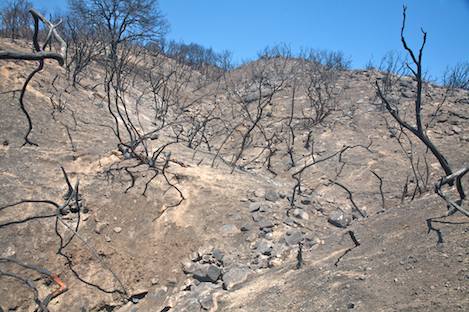
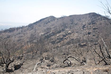
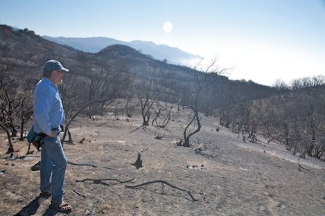
Of the 9,544 acres that burned during the Gap Fire, analysis of satellite imagery shows that more than three-fourths of the total acreage had received either moderate or high burn severity – an area just under eight square miles in size. Though it doesn’t detail exactly what the total acreage is that will be treated, the specific locations, or costs involved, the BAER team recommendations focused on the use of aerial hydromulching to replace some of the lost cover.
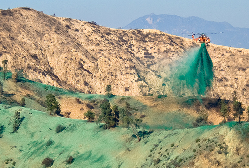
Hydromulch is a wet mixture that consists of 40 percent shredded wood and 60 percent paper with a guar gum-based tackifier that is used in ice cream as a thickener. Guar is a sticky substance that helps the mulch material cling to hillsides and steep slopes. A green dye is added to the mulch to make it easier for helicopter and airplane pilots to see what parts of the hillside have been covered and it is then sprayed on to build up a coating that resists erosion, helps trap moisture, and creates an environment in which native seeds and roots can sprout. This allows time for the new vegetation to take over its natural role in stabilizing the soil.
Though the county is not opposed to the use of hydromulching and will use it on areas outside the National Forest, the fact that that was all the BAER Team was recommending did not go over well. “Their own internal experts are telling us 300,000 cubic yards of material will be coming down into the canyons and possibly people’s backyards and may even overflow into the airport areas,” William Boyer, county communications director said, “yet all they seem to be willing to do is mulch their part of the burn area by air.”
Complicating matters is the nature of the jurisdictions involved in dealing with the post-fire impacts and the manner in which they cut across the Glen Annie, Los Carneros, San Pedro, Las Vegas, and San Jose watersheds. The upper band of these drainages– about half of the burn area–is within Los Padres Forest, while between Cathedral Oaks and the power lines much of them are within county jurisdiction, and below Cathedral Oaks the watersheds are within the City of Goleta boundaries.
County Flood officials are especially worried that a failure to deal with the flood impacts at any location in the watersheds could spell disaster in the valley below. “We tried to emphasize that this needed to be a team effort,” Tom Fayram, deputy director of Santa Barbara County’s Public Works Department, added. “We were ready to do everything we had at our disposal on the lower half of the burn area and in the areas we were most concerned about debris flows, but it didn’t seem like they were willing to do much on the upper half of the burn area to mitigate things there.”
Forest officials countered that they had explored every option offered to them by the county – straw bale check dams, straw wattles, water control structures, riparian planting, and channel clearing among them – but that none of them were practical and in some cases would require building roads into the burn area to make them feasible.
Even though he understands the difficulties in finding solutions on the Forest Service part of the burn area, Boyer was not mollified. “I was somewhat disappointed at what appeared to be a defeatist approach,” he said. “The BAER Team was negative about almost everything we proposed and it seemed like almost anything we wanted to see them do was too easily dismissed.”
Regardless of the approaches used, dealing with the impacts that could come this winter will be difficult at best. “Last winter we really only had two storms, but in the first one on January 5, nine inches was recorded at San Marcos Pass,” Fayram said with a note of frustration in his voice. “If that occurred again this year in such a short period of time, this could be a disaster; yet no one in the Forest Service seems to be that concerned about it.”
“I can understand the county’s frustration and we are just as frustrated,” Los Padres Forest Supervisor Peggy Hernandez commented. “We’ve gone through the BAER catalog of approved actions and looked at every tool available to us, which will work best in every different type of slope condition and geologic types. When you get down to looking at the difficulty of the terrain and seeing which of the actions might be appropriate, it became clear that almost none of them were right for this area.”
“What we are doing is not insignificant,” Assistant Forest Supervisor Ken Hefner explained. “The hydromulching will cost millions of dollars and it is proven to reduce hillside erosion.” BAER statistics appear to back this up. Computer modeling of the watersheds indicate that mulching can reduce the tons of sediments per acre by a factor of 10 in the upper ends of San Jose, Glen Annie, Los Carneros, and San Pedro Creeks.
“You also have to understand that the BAER recommendations are not designed to deal with long-term solutions or actions that might take months to get in place,” Hefner added. “What they look at are the type of responses that can be done quickly and effectively before the first rains hit. From below, you only see a handful of creeks coming down out of the mountains, but at the upper ends of each of these drainages are dozens of smaller side creeks and gullies that feed into them. You can’t put check dams or debris racks in every one of them.”
Hefner grabbed a piece of paper and began drawing a rough sketch of what one of these upper watersheds might look like with its web of smaller side drainages. “People underestimate how much impact the chaparral has in dampening the effects of the rainfall as it is coming down and how much water the duff on the ground can absorb,” he said. “We don’t have that chaparral or much of that duff in place up there right now and we need to replace it with something that can mimic what it does. The hydromulch will act like a dry sponge and capture a good deal of that rainfall until the native vegetation is back in place again.”
What both the Forest Service and county do agree on is that no matter what is done, all we can really deal with is a small to medium rainfall year.
To learn more about the BAER recommendations, efforts being made by Goleta City and Santa Barbara County public works agencies, and to share your concerns, a community meeting will be held at San Marcos High School auditorium next Thursday night, September 11 at 6 p.m.


