


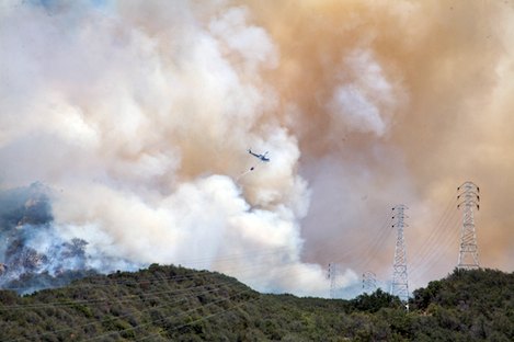
It started small, as many wildfires do, but within minutes gusting winds began to push the flames eastward toward Mission Canyon. I received word of the fire at 2:05 p.m., and by 2:20 p.m., a half hour after the Jesusita Fire was reported, I was up on a high ridge on the east side of San Roque Canyon, watching a tag team of two helicopters make a valiant effort to contain what was then perhaps a half-acre blaze.
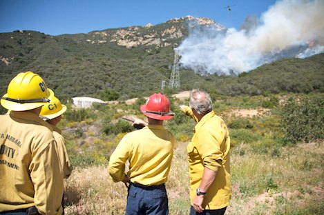
Both the Los Padres Hot Shots and a Santa Barbara Engine Crew from Lake Cachuma were already on scene, and as I approached I could see the frustration etched on their faces. Looking across a small canyon, we could spot flames pushing uphill near a section of the Jesusita Trail, the likely start point for the fire’s origin, but there was no easy way to get there. Winds were kicking up to 20-25 miles per hour in gusts, and spot fires were appearing one after the other east of the main front.
Mark Linane “Soop” of the Cachuma engine crew sized up the situation succinctly: “No place to anchor from; no place to retreat if we need to.”
Instead, Linanae’s crew was forced into a “sit and wait” mode, watching along with another 40 or so firefighters while the helicopters continued to pour water onto the fire. Unfortunately, the winds continued to increase in severity, and by 3 p.m. were gusting to 40 miles per hour. What was a half-acre fire when I’d gotten there was now expanding quickly up the wide canyon that Jesusita Trail follows to Inspiration Point.
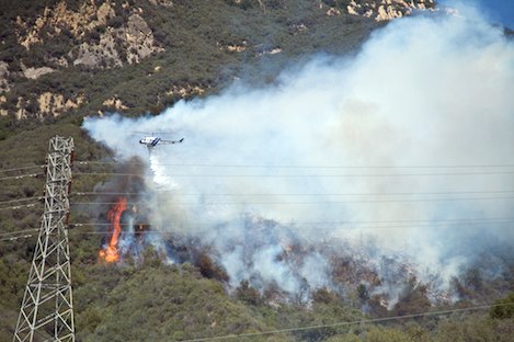
Shortly after, Stan Stewart, Los Padres Hot Shot crew leader, headed up the only route into the leading edge of the fire, a rough 4×4 Jeep road that follows the power lines to Inspiration Point. He’s back in 15 minutes, reporting that the flames are within 50 yards of the crest. With several hundred acres of thick chaparral along the south edge of the fire, there’s no way the crews can head up the Jeep road. A shift in the winds to the south would cut them off, and there’s no open space for safety up there if that were to happen.
For the seasoned crews, who are used to quick action and hard work, the frustration continues to mount. For the next hour we continue to watch the fire spread toward Mission Canyon, and at times the smoke plume reaches a thousand feet, bathing the city in thick brown-and-black smoke. While the helicopters are doing a heroic job of keeping the fire from moving down into San Roque Canyon or up toward the mountain crest, there is little to be done on the eastern flank.
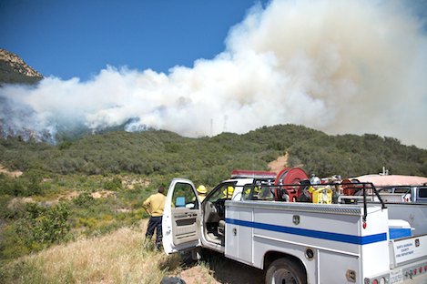
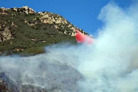
Tanker Base Closure Rankles Some: By 4 p.m. we are seeing the first of several retardant drops by planes far too small to make much of a difference. One of the crew members grouses about the air tanker base being closed in Santa Maria. Just two weeks ago, on April 24, Los Padres Forest officials had announced the decision to do what they termed “reorganize” the Santa Maria Air Tanker Reload Base from round-the-clock staffing to “call when needed” status.
“When conditions and events warrant, Santa Maria will resume reload operations within four hours of activation,” the Forest Service press release noted. “Throughout California, air attack resources are available within a 34-minute period when requested.”
By this time, the Jesusita Fire has been burning for more than two hours, and there is wondering why there aren’t more air resources here. “This is a classic case of a fire you can only fight from the air,” another crew member says to me. As I am, he’s wondering why there aren’t other air tankers working the fire.
Of the closure of the Santa Maria tanker base and the grumblings from other local fire agencies, Forest Supervisor Peggy Hernandez said, “I understand the concerns of our cooperators, and I appreciate their willingness to share their thoughts and listen to our perspective. We all have the same goal: to speed every available resource to suppress fires and protect our communities at risk.”
Though this isn’t the time, there will be a need for a much more thorough discussion of how resources are prepositioned for such quick-moving blazes as the Jesusita and Tea Fires.
Fire Starts Along Jesusita Trail: From our position on the ridgetop knoll near the start point of the fire, it is clear the fire has started along a portion of Jesusita Trail. Those who know the trail know that on the west side of Inspiration Point it follows the Jeep road steeply downhill, then turns off the road, drops down several switchbacks, and follows a chaparral-covered section of almost level trail for three hundred yards before switching back and forth down into upper San Roque Canyon.
The fire’s origin is near the western end of the level section, tantalizingly close to where we are but separated from us by a few hundred yards of almost impenetrable brush. Given the fire’s hard push to the east and lack of access to the start point anywhere but from the trail, fire inspectors will be focusing in on this area as soon as it is safe to get there.
Meanwhile, I follow another Jeep road east to the top of Spy Glass Ridge to get a better handle on what is happening on the east end of the fire. From radio reports coming from the engines stationed here, it is clear the fire has pretty much followed the Jesusita Trail over the Inspiration Point knoll and down into the West Fork of Mission Canyon.
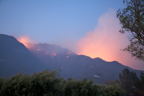
During the next several hours, the news is good and bad. Flames continue to lick the top of the ridge and threaten to make a direct downhill move when the winds shift south directly toward Spy Glass. The gusts are almost continuous, never dropping much below 20 miles per hour and peaking at 40-50 miles per hour.
But as the winds grow in intensity, they are also getting colder. The humidity is rising, and the fire is not sustaining itself as a major front as it did in the Tea Fire. Pockets of flames continue to burst uphill in lengths that range from 15-40 feet in length, but they die back down quickly. The brush is still moist enough to keep the fire from spreading without the help of the huge winds.
By 9 p.m. the winds have died considerably. I’m sitting with two Spyglass neighbors, Bill and Glenn, on the outside wall of Glenn’s home. Both owners have done everything right: The houses are virtually bombproof, and the brush has been cut back 50 yards on both sides of the ridge. “We just had the grass weed-whacked last week,” Glenn tells me.
As I head down Tunnel Road a bit later, I look back uphill near the end of Tunnel Road. The whole side of the canyon, perhaps a quarter mile up from the locked gate at the end of Tunnel, is lit up, thousands of orange-red coals silhouetting the ridge leading up to Inspiration Point. A few isolated patches of chaparral burn, but all is quiet.
Tomorrow promises to be a huge day on the fire lines. Winds are expected to gust again, and temperatures on the upper hillsides could grow into the 80s. The potential is there for this to become a two canyon fire, if the wind shifts downhill early.
The two questions on everyone’s mind up on Spyglass Ridge are simple ones: How hard will the wind blow? Will there be more air resources than there were last night?


