

From my perch on Painted Cave Road, I can feel the cool, moist air begin to creep in. It is 10 a.m. and conditions are starting to improve on Saturday morning, the first day in the past five that firefighters have started to feel more comfortable.
On Friday, the night before, sustained runs on both the east and west end of the fire had firefighters worried. On the east end near Gibraltar Road, the flames that had been climbing the ridge just south of Flores Flats erupted, pushing down into the west and main forks of Cold Springs Canyon. The fire burned out the first quarter-mile of the upper West Fork Trail and advanced into the main Cold Springs Canyon to Tangerine Falls. Then cooler marine air stooped the eastward advance about midnight.
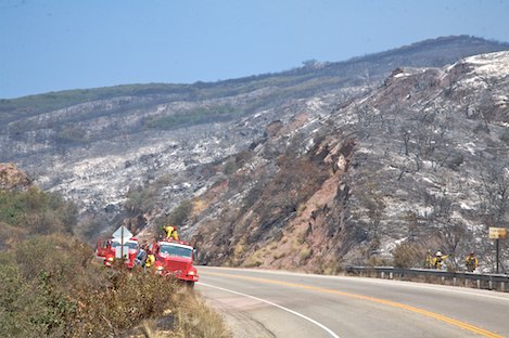
On the west end of the fire, winds picked up in the later afternoon, causing the fire to overrun the Windy Gap Fire Break along much of the middle section of the break. Much of the mountain side of Highway 154 has burned from the first passing lane about two miles up from Highway 101 to Maria Ygnacio Creek.
The fire also crossed Highway 154 and threatened ranches in the east fork of Maria Ygnacio creek as well. However, by Saturday morning, the fire on the west side of Highway 154 was mostly out, with only a few small spot fires visible along the highway. Residents of the San Marcos Trout Club area should be reassured that their homes are currently out of the fire danger zone.
Nearer to Painted Cave and above Highway 154, the fire burned to upper Maria Ygnacio Creek and several small spot fires were visible on the Painted Cave side of the creek. However, as the marine air moved up into the upper canyon after midnight on Friday, the fire cooled down in this area as well. From my Saturday vantage point here on Painted Cave Road, this cooler air is working into firefighters hands, pushing the columns of smoke and spot fires northeast and away from Painted Cave.
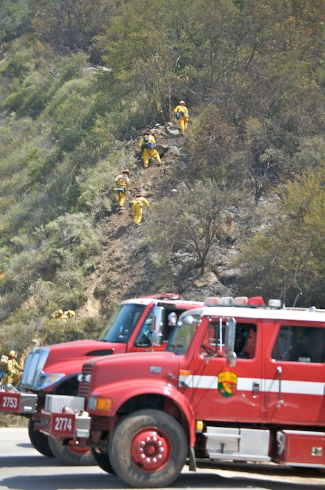
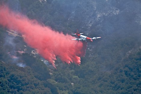
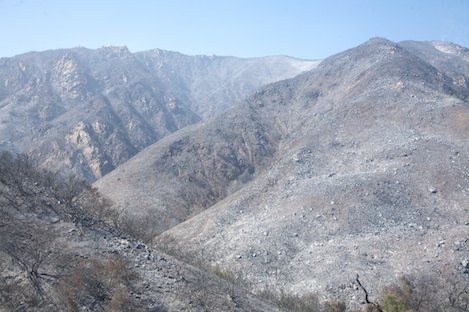
Hand Crew Work Begins: By 10:30 a.m. Saturday, air attack begins to paint the canyon with layer after layer of retardant while hand crews down in the canyon begin to prepare to go direct in an attempt to cut line in between the fire and Painted Cave residences. Shortly after 11 a.m., the first of the big Erickson Sky Cranes begins to drop more retardant near the hand crew, pinpointing the smokes and providing the crews with a safe zone in which to work.
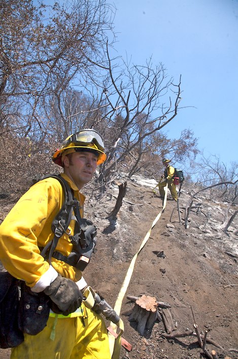
I head down into the canyon to join the hand crews and see how their progress is going. The crew is from Camp 11 (L.A. County Fire) in Acton, California, and is made up of low-risk prisoners who’ve chosen to spend part of their sentences supporting fire efforts here. The work is tough. From above I could see dozens of the crew cutting their way through the brush. From below I discover the brush is mostly huge stands of poison oak clinging to the side of what are hills steep enough to be called cliffs.
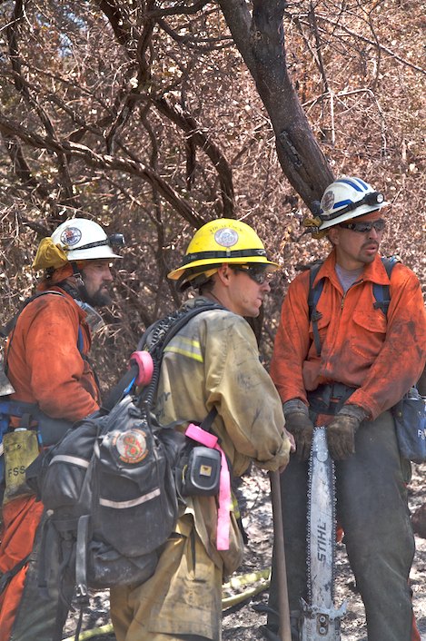
This is the tough work on the fire lines, not as glamorous as the air drops from above, but absolutely essential to putting out the fire. Over the next few days, crews like these will be covering miles of fire perimeter such as this, cutting line in the worst of terrain, and making it possible for the time when 100 percent containment will be declared.
Saturday Morning Briefing: Incident Meteorologist Rob Balfour tells the assembled firefighters that today will be another good day for working the lines. It is cooler, even wet down in the lower canyons, and the moist air stretched to the 2,000-foot level, almost to San Marcos Pass. Balfour says as the upper hills heat up and carry the air even further uphill that it should reach the 3,000-foot level, covering much of the Santa Ynez Mountains.
Along the crest, firefighters face a dilemma. The night before, they have burned out the front side of the mountains from La Cumbre Peak to the east. Much of Saturday’s work has been devoted to putting out hundreds of hot spots in this burn area so that containment can be declared along this section of the fire line.
However, west of La Cumbre Peak, there is still a half-mile wide stretch of brush along the front side of the mountains that goes for a number of miles to the Windy Gap Fuel Break. Firefighters weren’t able to burn this area out on Friday night and they won’t be abler to this weekend as well. CalFire’s operations section chief Phil Venaris paints an interesting picture.
“The fire is cool enough, it isn’t going to burn up to us on Camino Cielo,” he says, “but we’ve got enough of an uphill breeze that we can’t burn out from the top back down to it either. It’s way to dangerous for us to get hand crews down there too.” What Venaris proposes is that air attack hammer the fire line up there to see if they can’t drop enough retardant and water to get the fire “to put itself to bed” on its own.
“Of course,” he says, “if anyone wants to volunteer to build hand line down in those canyons, you can give me a holler after the briefing.” Everyone laughs. The firefighters are feeling much better today.
Conditions Could Change: Deputy Incident Commander Kelley Gouette tamps this good feeling down a bit when he adds a few words near the end of the meeting. “We are definitely not out of the woods,” he tells everyone. “We’ve got a window right now before we start getting sundowners winds again next week. We won’t see any large fire movement today so now is the time to button up the lines and secure as much of it as we can.”
“By Monday night or Tuesday night when the winds pick up, we could be field-testing our efforts,” Gouette adds. “Let’s make sure we keep any flare-ups inside the fire perimeter.”
A weak storm system is predicted to move across the Pacific Northwest Monday, resulting in a high pressure system building that will cause northerly winds (southerly direction) to develop into a weak-to-moderate sundowner condition that could last through mid-week.
While Saturday was a good day on the fire line and the same should hold true on Sunday today, the fire fighters know they still have a lot of hard work ahead of them. On the east end of the fire, crews are preparing to begin building line from the West Fork of Cold Springs Trail up through the Tangerine Falls area to the crest, beautiful country if you are a hiker but an ugly place to cut a 10-foot-wide line straight uphill.
Dozer crews are also continuing their work in Romero Canyon as well. The old jeepway was cut about halfway down yesterday and they expect to reach Bella Vista at the bottom today.
As is the case with many of our area’s wildfires, it is a good news/bad news kind of day. With luck, the firefighters will get enough work done on the fire line today to keep the bad news away when the winds begin to change.


