

Continued good progress was made by firefighters yesterday as they inched forward to complete fire lines in the San Rafael Wilderness portion of the La Brea Fire. Hotshot crews continue to make good progress on the estimated 10 miles of fire line yet to be completed. In the afternoon, hot temperatures increased the intensity of the fire in portions of the wilderness, but air tankers and helicopters helped to check its spread. Most of the crews stayed overnight near the site to continue work in that area today.
Mop up of hot spots 300 feet into the fire is continuing in many areas, and those involved are finding fewer and fewer hot spots. Interior smoke and some flare-ups continue well inside portions of the burned area, which do not pose any serious threat of crossing the containment lines. Firefighters monitor these interior flare-ups and usually do not take any suppression action on them since it is not needed. The last evacuation warning was lifted by the Santa Barbara County Sheriff’s Office late yesterday for the area bound by the Sierra Madre Road, Highway 166, Cottonwood Canyon, and Spoor Canyon. There are currently no evacuation notices in effect anywhere around the fire.
The forecast is much the same as the past several days with temperatures in the 90s. Under these conditions, the fire becomes most active between 11 a.m to midnight. Fire operations and incident management teams need to keep very aware of current weather conditions and be able to anticipate changes in the weather. In order to do this they use remote automated weather stations or RAWS. Portable RAWS stations are sometimes placed at fires on a temporary basis. The La Brea Fire is currently using several of these sites, Fire RAWS 5, 6 and 7. For additional information on RAWS sites.
U.S. Forest Service Special Agents, the Santa Barbara County Sheriff’s Office and fire investigators determined the La Brea Fire was caused by a cooking fire at an illegal marijuana drug trafficking operation within the forest. The La Brea Fire Tip Line is still open, and anyone with additional information helpful to this ongoing investigation is urged to contact 805-686-5074.
An emergency closure order is still in effect for portions of the Los Padres National Forest in and around the fire. For more information, please contact Fire Information at (805) 961-5770 from 6am-10pm.
The Santa Barbara County Public Health Department and the Santa Barbara County Air Pollution Control District today canceled the Air Quality Watch for Santa Barbara County. Conditions are improving thanks to favorable weather, and significant progress made in containing the La Brea Fire. The agencies will continue to monitor the situation and will issue new air quality advisories if conditions change. Residents are advised to be cautious when cleaning up ash to avoid stirring up particles and especially to avoid using leaf blowers (and to ask landscaping services to avoid use of leaf blowers). Anyone with heart or lung problems should not do ash cleanup.
Due to emergency vehicle traffic and congestion on Highway 166, the public is urged to use extra caution when traveling the highway.
Basic Information
Cause: Fire was started by a cooking fire at a marijuana drug trafficking operation.
Date of Origin: Saturday August 8, 2009 approximately 2:50 pm
Location: 21 Miles east of Santa Maria
Resources: 50 Engines, 49 Crews, 16 Dozers, 60 Water Tenders, 11 Helicopters, and 5 available Fixed Wing aircraft
Current Situation
Total Personnel: 1,520
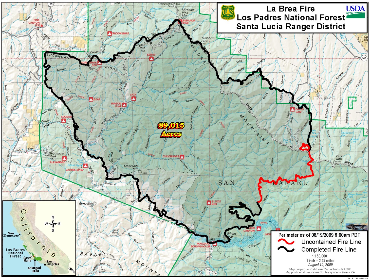
Size: 89,015 acres
Percent Contained: 94%
Fuels Involved: Primarily Chaparral with areas of grass and timber.
Fire Behavior: There was fire activity on the south side of the Sierra Madre Ridge where the fire made short uphill runs and continued to spread laterally. Interior pockets continued to burn in many portions of the fire. In the wilderness area, retardant was very effective in keeping the fire in check.
Significant Events : At this time, current suppression activities appear to be succeeding. Crews continued to hold and mop up from the Mazana Schoolhouse north towards the Treplett fuel break by Miranda Pine. Direct and indirect line was constructed on the east side by Schoolhouse Canyon down to the Sierra Madre Ridge. Direct, indirect, and air resources are being used to construct line from Manzana Schoolhouse north towards Sierra Madre Ridge. Rehab efforts have begun from Miranda pine to Schoolhouse Canyon.
Outlook
Planned Actions: Mop up from Mazana Schoolhouse north towards the Treplett fuel break by Miranda Pine. Hold and mop up from the east side by Schoolhouse Canyon down to the Sierra Madre Ridge. Direct line was constructed from Mazana Schoolhouse north towards Sierra Madre Ridge.
Growth Potential: High
Terrain Difficulty: Extreme
Remarks: Fire is being managed under Unified Command with California Interagency Management Team 3 (commander Pincha-Tully), Cal Fire (commander Heil) and Santa Barbara County Fire Department (commander Schmitt). The two structures destroyed were a non-operational White Oaks Ranger Station and a hunter’s cabin to the east. Fire line constructed in the San Rafael Wilderness will be done using Minimum Impact Suppression Tactics (MIST).
The La Brea Fire is being managed under unified command with California Interagency Incident Management Team 3, CAL FIRE, and Santa Barbara County Fire. Type 1 Teams are national resources which can be sent anywhere in the US, when needed. The goal of CA IIMT 3 is to provide professional incident management public service through flexible planning, decisive implementation, professional execution and constant assessment of actions taken.


