

“Floods and quakes strike hard and fast, like lightning. Then they’re gone. Wildfires start deceptively small, building up power, then usually rage angrily for hours, days–threatening, threatening.
“They terrorize, chase us from our homes in nightclothes and burn our belongings and our baby pictures. They trick us into thinking we can tame them with puny hoses carried by brave people and air-borne squirt guns wielded by heroes.
“They kill us.
“There’s something malevolent about wildfires. They aren’t acts of God. They’re nature striking back at mere men presuming to claim possession of the mountains.“
Barney Brantingham
July 26, 1987
THE CANYON WALLS IN THE MOUNTAINS behind Santa Barbara are steep and narrow, and where the sandstone cuts across the creekbeds, there are refreshing pools that are clear and crisp in springtime. Thick clusters of alter filter the sunlight, providing a soft cathedral-like setting that is beautiful.
The sandstone is Eocene rock which has weathered slowly, the upthrust crags forming a series of triangular-shaped flatirons that rise dramatically from the shoulder of the city and create the juxtaposition of sea and summit that gives Santa Barbara its unique character.
Life in chaparral country begins in these canyons, thin creases of abundance where wealth is measured not in hard currency but in liquid; water is the life force which allows these plants an easier life. Literally they have their feet in the water: the leaves are larger and greener than in the chaparral, and they are able to transpire more freely than those which live but a hundred feet above them.
There are thin wisps of trails which lead up through and out of these canyons to the crest of the mountain wall. For the Chumash these trails provided important trade routes leading to interior tribes; today they offer needed relaxation for those who need to escape the city for a moment or two.
These trails meander through scattered groves of oak in places; at others switching steeply around headwalls of bedrock into the heat and openness of the chaparral hillsides, and back again into the coolness of the creekside. Here life seems to decelerate from the twentieth-century pace that has been forced on us.
But despite its beauty and the recreation that is provided, the vegetation here, too, must burn. From San Marcos Pass east to Casitas Pass there has not been a fire since before World War II.
AFTER THE REFUGIO FIRE Mission Canyon residents wonder. How would a fire be handled if it were to break out in their canyon today? The brush that fills the mountains behind them is no less thick than that in the Refugio area.
“Assuming it is spotted by the La Cumbre lookout,” they are told, ” the lookout tower would report its location to the ranger headquarters at Los Prietos by phone, and crews from the San Marcos, Mountain Drive and Rincon guard stations would roll immediately with pumpers on radio orders from Los Prietos.
“Monitoring the radio, Santa Barbara headquarters would alert at once the available air tankers at the airport, and within minutes they would be dumping loads of borate on the area. The Hot Shot or reserve crews would roll in from Los Prietos.
“The County Fire would also be notified early, since any part of the canyon not in the forest is in the county’s primary jurisdiction.
“Because the forest perimeter area near the coast is within a “red zone” which stands as a threat to the forest and its vital watershed, the Forest Service has an agreement with the coastal units that if anything happens there, it will rush men in regardless of boundary lines.
If the canyon fire turned out to be more than the county and Forest Service could handle, city, Montecito and Carpinteria units would be called on for aid, and the Forest Service would radio neighboring Santa Maria and Ojai districts to send men and equipment.
If the fire turned back upon the city and raged through the foothills beyond control of city forces,” it is added, “a special long distance phone which has the highest priority of any phone in the city would be picked up, causing a red light to flash at the local exchange switchboards. Operators would put the city chief in immediate contact with the Ventura headquarters of the Disaster Control Center which would begin summoning aid from the south under a ‘fan out’ system which would eventually reach Los Angeles units if the situation worsened.”
Mission Canyon residents are unsure what to think: hoping for the best; they still think and prepare for the worst.
Cooperative plans such as this result from the disastrous 1960 California fire season. Fire officials from throughout the state meet after the fire season has ended. All agree that there needs to be better advance arrangements for manpower so that it can be put on the line as rapidly and efficiently as possible, and for more thorough and intensive training of fire personnel.
The need for more money is also recognized. Detection, prevention, initial attack forces, equipment–both ground and air–tools, and fuel treatment all compete for what are woefully inadequate fire control dollars.
Among priorities which emerge from the meetings as most important are: increased manpower; better organization; more modern equipment; and land treatment measures. All of them agree that burned acreage is not being held within tolerable levels. The foresters and state officials recommend four strategies that become the core of the 1960 State Fire Plan.
First, initial attack forces would be strengthened by doubling the size of fire and pumper crews, increased use of aerial attack, including fixed-wing air tankers, helicopters, and helitack crews, and development of hot shot crews which are well trained, fully equipped, and highly mobile.
Second, better access would be provided into previously inaccessible areas, reducing critical attack time.
Third, hazard reduction would be implemented immediately. This would include fireproofing areas of high risk, construction of fuel and firebreaks, and conversion of brush into less flammable types.
Last, the fire prevention program would be increased and intensified.
When the Coyote Fire breaks out on September 22, 1964, due to the lack of funding, the plan is far from being in place. Manpower is only half of that recommended.
WITHIN SEVERAL WEEKS AFTER CONTAINMENT of the Refugio Fire, a prominent conservationist and rancher approaches the Forest Service, wondering if they could be influenced to remove the brush from a good deal of the front country which hadn’t burnt in this fire.
While he is supportive of the idea of new and more advanced equipment, more money, and better coordination to fight fires, it is his thought that reducing fuel levels might do more to alleviate the destructive threat of fire than any amount of attack forces might.
Balancing fire prevention against its suppression is always a difficult proposition when the dollars provided are insufficient.
The dilemma is expressed best by Nolan O’Neal, who has been in charge of this most recent fire. “We can’t live with these big, unbroken, highly inflammable brush fields where fires in extreme burning weather are extremely dangerous and difficult to control.
“Neither can we live with barren watersheds and the resultant floods, erosion, and siltation of reservoirs.”
On September 20, 1955 the Federated Sportsmen of Santa Barbara back a program of strip-burning of the brushlands aimed at establishing a vast system of natural firebreaks.
Soon thereafter, on September 29 a meeting sponsored by the County Farm Bureau is held at the Biltmore to discuss the fire situation. Los Padres Forest Supervisor Robert Jones speaks first. Never in his almost 30 years of fighting fires has he ever seen one “so difficult, so complex and so unpredictable.”
“Now that the fire is out,” he says, ” the most pressing question is how to prevent such disasters from repeating.” He offers a “plan.”
O’Neal presents it. “The big brush fields must be broken into more manageable units,” he tells the 75 concerned citizens who have attended. “Barrier strips must be built around homes, ranches, and other developed areas. “
“The Forest Service is prepared,” he adds, ” to use any reasonable tool to do the job, whether it be bulldozers or brush discs, chemical sprays or even fire.
“You can’t handle this problem by hiring school boys in June who leave in September,” he emphasizes. “Much more research is needed into wind and fire behavior, fire retardants and studies of what kinds of grass or other cover might succeed the brush.
“The program is not easy, it is not cheap and it’s not simple,” O’Neal concludes.
In 1955 the amount of money the Los Padres Forest Service receives from Congress to protect the valuable watersheds inside its boundaries amounts to 11 cents per acre. Clearly this is not enough.
Those from the Mission Canyon, Montecito, and Carpinteria area want to know what can be done immediately to reduce the fire hazard. They know the next front country fire, should one come, will be in their areas.
Others want to know what the Forest Service is prepared to do west of San Marcos Pass–in the area covered by the fire–to prevent the regrowth of the brush.
In spite of the earlier admission that the use of fire might be a good idea under the right circumstances, in a rather lengthy discussion of controlled burning, the Forest Service argues against its use.
Many people are upset by this point of view, and argue strongly that the policy must change.
“Controlled brush burning is as different from wild fire as a blaze in a fireplace is different from a house on fire,” one person says.
‘Worthless brush covering much of California’s foothills encourages the spread of wildfires, hampers economical fire control, endangers valuable forest areas and is a constant threat to other adjacent property,” responds another.
“We must recognize that, regardless of what is done, those brush lands are going to burn sometime,” retorts still a third. “So, if we burn this out progressively and reduce the volume of fuel from the brush, we will have less disastrous fires, more grass, more water from our watersheds and less erosion in the long run.”
The Forest Service is not swayed by arguments promoting the use of fire in the chaparral. Rather, it supports the creation of an extensive set of fuelbreaks and use of what is known as type conversion, which involves breaking the brush up with the use of bulldozers, discs, chains and herbicides and reseeding these areas with grasses.
County farm officials later visit San Luis Obispo, where a controlled burning program has been officially organized. A controlled burn, they are told, consists of bulldozing a line around the area to be burned, providing water supplies, manpower, and dozers on the perimeter, then setting fire to the area inside it.
The Sisquoc Grange Range Improvement Association is formed to implement this policy. The Grange burns and reseeds 6,000 acres of private land in the Santa Maria area.
Locally the Santa Barbara Range Improvement Association is created and, in cooperation with Santa Barbara County Fire, begins to burn its members’ rangeland in 1956.
Ranchers, their worries increased by the Refugio Fire, are making every effort to protect their property, and are openly critical of what they see as the Forest Service’s refusal to support fire prevention efforts fully.
But this type of criticism is unfair. Ranchlands are relatively open, mostly grassland, and their rolling hills are mostly accessible by vehicle. The grasslands burn cool, the fuel insufficient to cause the firestorms experienced in the higher country. The chaparral, by contrast, is choked with dead brush, and much of it is in such rugged topography as to render firelines impractical. Further, there are huge, unbroken blocks of brush–thousands of acres of it–that cannot hope to be burned until it is broken up into much smaller chunks.
The County does not escape citizen criticism either.
On November 18, 1955 the Santa Barbara News-Press publishes an editorial entitled, “No Lessons Learned from Refugio Fire?”
“With the first abundant, welcome rains another fire season has come to an end. It was preceded by its demise, we fear, by the apparent death of any sincere effort toward a modern, county-wide fire prevention and hazard abatement program That all but died aborning…
“Many citizens expected that full advantage would have been taken of the new public appreciation…Most fire-conscious individuals had long been aware that almost all our serious brush fires have started from careless disregard and/or illegally maintained fire hazards on private property at the edge of or within the boundaries of Los Padres National Forest….The county’s Fire Advisory Committee had one of its rare meetings during the week without commenting on any of the improvements which have been so obvious to so many people. More and more, it begins to appear that the committee was chosen by the Board of Supervisors with the principal view of maintaining the status quo….”
As memories of the Refugio Fire recede many wonder if its lessons have indeed been learned. Gradually, as grasses and herbaceous plants begin to cover the mountainsides and crown sprouts from the burned over chaparral begin to make their appearance, the fire’s horrifying visual evidence dissolve. Gradually the list of woulds dissipates as well.
Wide fuelbreaks and access breaks would be built. More money would be available. Stricter building codes would be developed. Roofs would be fireproof; electrical wirings more safe. Homes would not be built near the brush unless connected to water mains large enough to be effective in fighting fires, and brush would be cleared from wide areas around each house and from along roadways.
Committees have been formed, speeches made, editorials written in the aftermath of the fire. Action has been promised, all this is in September, and October, and early November of 1955.
By the early 1960s much that is on the list has still not been completed.
ADVANCES ON THE TECHNOLOGICAL FRONT promise to help make suppression efforts easier. An aerial tanker is first used on the Mendocino National Forest in 1955. Souped up crop dusters which carry a 120 gallon mixture of water and borate, they prove very effective.
Sodium calcium borate, as it is technically called is mined in Death Valley, blended, and when mixed with water is whitish in color and the consistency of pancake batter, producing a compound that remains in suspension for long periods of time without stirring. It has a high melting point, about 1,800 degrees and when it dries on the brush it sticks, coating everything in its path with a substance that cools and slows the fire down so that fire crews can get in and fight it.
Ground crews are the first to appreciate the new technique because they know they can call for a borate bath if flames threaten to trap them. “We believe it will become standard practice,” Angeles National Forest Supervisor William Mendenhall says after they are used for the first time in Southern California on a fire in his forest in 1957. “It definitely cools down a fire to the point when land crews can move in with shovels and bury it.”
The planes are ex-Navy patrol bombers known as TBMs and PBYs. The Municipal Airport now becomes the initial attack base.
Not everyone believes in the use of these planes, however. Using them is expensive, costing nearly $1,000 an hour, and they are considered risky. Pilots regularly fly through flames and dense smoke in tricky canyons to deliver their 1,200 gallon payloads at very low altitudes. In 1958 alone, seven air tankers crash.
The Forest Service is happy to have them, however, understanding that the expense and danger pale into insignificance in comparison to the damage and havoc a major fire can cause.
Aerial tankers are first used in Santa Barbara on an arson-caused fire near San Marcos Pass in 1957. They prove their worth in July, 1960 near 7,000′ Cobblestone Mountain in almost completely inaccessible country, where a lightning strike initiates an 11,000 acre blaze. During the seven days of action, pilots drop 157,400 gallons of borate on the fire and the planes are vital to getting it under control.
On July 23, a sleeper fire caused by another lightning strike in Cherry Canyon behind Wheeler Gorge erupts, threatening to expand the fire line dramatically . The tankers are diverted, bombing it out of existence before it can become a threat.
The helicopter joins the bombers in the air, replacing the pack horse as a means of resupplying fire lines in remote country. The first, an Autogyro, is actually a fixed wing plane fitted with rotating blades, and is used in the Los Padres National Forest in 1922 for reconnaissance, but it is not until the late 1950s that helicopters are fully adapted to use in fires.
In 1957 seven Bell 47-B helicopters are introduced on the Gale Fire in Angeles National Forest, moving over 3,000 firefighters during a 10-day period. In 1959 a technique is developed that allows helicopters to lay hose on the fire line and in 1961 fixed-mounted tanks are installed on them making it possible to drop water and retardant on a fire.
“The helicopter can get into fires faster and with more equipment,” Don Landelis, a civilian pilot who contracts with the Los Padres Forest Service explains. “It can lay fire hose, fly in men and help put out small fires.”
Heliports are established at the Los Prietos and San Marcos Ranger Stations where firefighters are on duty day and night and must be ready to be in the air within five minutes after receiving a fire call. This is known as heliattack. The initial attack now comes from the air, from helicopters which ferry troops and supplies.
The Forest Service also develops what is known as the helitanker, an airborne fire truck, in essence, which combines the advantages of the tank, pump, and hose of a ground fire tanker with the speed and mobility of the helicopter.
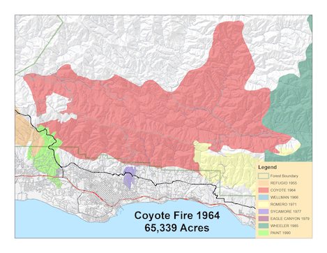
During the Coyote Fire, 19 of them will be used, along with 14 helitack crews from the Forest Service, Park Service, and Department of the Interior. During the 12-day fire the helicopters log 1,172 flight hours, move 8,900 men, 250,000 pounds of freight, and drop 28,000 gallons of water and fire retardant.
Addition of these technological advances changes the nature of fire tactics; planning is now oriented towards the military principle of coordinated, simultaneous, air and ground attack.
The Los Prietos Hot Shots become the strike force which is designed to lead the attack on the ground. Formed in 1949 as part of a U.S. flood project, it is their job to protect the Santa Ynez Valley watershed. Today they have become one of the most well-honed and professional fire fighting forces anywhere, recognized throughout Southern California.
During fire season they sleep in two barracks housed behind the Santa Barbara Ranger District headquarters. Arising at 5:30 they run first, keeping in top physical shape, with daily classes and drills in use of tools and fire fighting techniques.
When a fire is reported in they scramble quickly and within a few minutes time the 24-member crew is loaded in the back of the fire truck and are on their way to the fire.
Their job is to create firebreaks in the thick chaparral using only tools and an extraordinary amount of muscle power. Once on the fire the Hot Shots break into three groups, two teams of eight men each and one of seven whose job is to remove branches and other flammable material from the path cut by the other two. In the lead are the sawyers as they are called–those who man the chainsaws, quickly and expertly cutting away the chaparral. It is an extremely demanding job–but on the fire line there is no job any of the Hot Shots are more proud.
THE COYOTE FIRE STARTS WITHIN A FEW INCHES of the Santa Barbara city boundary, one-tenth mile below Mountain Drive just before 2 pm on Tuesday, September 22. It is caused by a car’s faulty exhaust system.
A local resident, who sees flames in the grass at the road’s edge, phones the Santa Barbara City Fire Department at 2:02 pm, minutes later. The report is instantly put out on the radio, which is monitored by the Montecito County Fire Department and the Forest Service.
The response is immediate. Within 5 minutes two aerial bombers on their way. City fire sends one engine; Montecito County Fire two. One-half acre of the dry grass has been consumed by the time they get there.
Seven minutes after the report is received the combined forces of the Forest Service, and City and County fire have put 14 men on the fire, illustrating how well coordinated these local agencies have become
By 2:10 pm tankers, patrolmen, Hot Shot crews, and helicopters are also on their way. In case the fire is not controlled quickly, the forest dispatcher has ordered an additional 5 air tankers and called for support from all four ranger districts in the southern portion of the Los Padres National Forest.
The initial attack plan is to confine the fire to the east side of Coyote Road. This fails when the flames burn up through the crown of a large oak and gusting winds fling hot coals to the other side of the road and across Mountain Drive to the north. Quickly the forces divide: the Forest Service taking the portion above Mountain Drive; City and County fire that below.
Above Mountain Drive the fire heads towards several houses, and rather than starting perimeter control, the Forest Service personnel divert their efforts towards protecting them. Pumper rigs and other support equipment find it difficult to get to the fire scene; it has been clogged by sightseers and local residents who rush to the area to protect their own homes.
The fire spreads rapidly up hill and out of reach of those pumpers which are in place. The Montecito Fuelbreak is above the flames, and is designed for exactly such a situation, but spot fires thrown out by the fire shoot over it and this line is lost. Later, the Forest Service estimates that the Coyote Fire would have been controlled at about 15 acres had these spot fires not occurred.
At the same time this line is being lost the aerial attack begins but the bombers are hampered by power lines which make it impossible for them to get in as close to the fire as they would like to have. As the fire spreads beyond the transmission lines the aerial bombing becomes more effective and though it has reached 200 acres in size by 6 pm, the spot fires are being handled very effectively from the air.
Because the initial attack has failed to hold the fire at Mountain Drive, forces are regrouped for a sustained push to secure a perimeter line further up the mountain wall. Four tractors arrive and are assigned the job of coming in over the top of the fire to a power line right-of-way.
At 5 pm all agencies meet to establish zones of responsibility. The Forest Service is given the area above Mountain Drive; City, County and Montecito Fire Departments the job of handling all structures and fire lines below Mountain Drive.
The aerial bombing is going very well and the possibility of controlling the fire at about 300 acres looks very good.
But the fire is as erratic as the winds. Just as the fire is quelled, it breaks out again, is quelled, rebreaks out, is quelled, only to rebreak out once again.
The key to keeping it quelled are the B-17s, AJ-77s, F-7-fs, and TBMs which drop 52,600 gallons of fire-retardant liquid from the sky in 58 fly-overs between 2:30 pm and darkness.
When darkness comes the bombers are grounded and control of the fire is lost.
Bill Richardson is a writer who lives with his wife, Frankie, and two small children on Mountain Drive. Their story is among the many that is reported by the News-Press.
It is an ordinary day as the family heads to the beach. That is until they see the smoke billowing over Mountain Drive.
Rushing home, they are stopped a short distance from it by police at Coyote Road and Mountain Drive. They pile out of the car and run up the hill, straining to see through the smoke.
“At a bend in the road they stop and see the flames rushing toward the adobe. The kids clutch at Frankie’s legs, and Frankie cries.
“I guess it’s gone,” he says. “Everything’s gone.”
Bill is referring to the house. It is a roughly-constructed adobe which Bill has built himself on a rocky crag overlooking the coast.
There are also the animals. One is a burro which is tethered near the house under a valley oak with the Mexican saddle the neighborhood kids so loved to ride. The others are dogs, four of them: Blue (a white Australian shepherd with a marble eye); Chica; Tejon; and a big black one, dubbed Hondo, which is scarred from a hundred encounters with the wild pigs Richardson hunts with such great skill.
There are many manuscripts too, including one about jungle warfare in the Pacific which he has almost finished. It is painful to think that all he has created is about to go up in smoke.
As the family watches, the fire races up the hill goaded by the mean sea breeze. Frankie cannot bear to look.
“Then the bomber came, that sweet bomber,” they remember later.
It appears before them, almost magically, slicing through the pall of smoke and into the clear blue sky, the rusty chemicals flooding from its bulky belly.
“Just at that moment, the very moment, that sheets of flame leapt towards the house on the cliff. They were 60 feet high, and when a fire gets going that way, it takes everything in its path,” Bill says later, describing what he saw.
“It was a superb piece of flying. The rusty cloud settled, right on target. The flames withered, subsided. The smoke cleared, and there was the house.”
Nearby, firefighters whistle in admiration at the skill and daring of the pilot. Even Frankie dared to look now
.”Thank god. They bombed us–dead on,” says Frankie.
“That’s fifteen years of writing,” said Bill, quietly.
“It is hard to express the glowing thrill, the tightness in the throat and the quick blinking to make sure what you saw was there,” a reporter notes, “but at the height of the Coyote Fire yesterday afternoon, there was a great B-17 flying into the smoke and flame.
“It was almost something from another world; it certainly was from another era; it really was a ‘Flying Fortress.’ But this time it was on a mission of aid, not of destruction.”
The B-17 which bombs the Richardson house is named Old Girl.
The assault from the air is glamorous enough in moments like these, but mostly, it is hard work, and daring enough to test the best of men. For the six hours that 50-year-old Howard Haradon has maneuvered Old Girl through the smoky canyons above Mountain Drive, he has earned $1,320–a fat day’s paycheck for most of us, but in the mountainous war zone it is well earned. The bombing runs are tense, eight of them down into the tight canyons, barely 75 feet above the very hard ground, one of them fortunate enough have saved the Richardson homestead.
Just as capriciously as they have begun, the winds have died down and the leaping flame subsides, turning into orange-colored embers. The whole mountainside looks like a giant glowing coal. Tensions ease. The heat and the roar of flame give way to choking smoke. The people drift back to their homes
Mountain Drive is littered with hose, and thronged with fire company pumpers which are laced with columns of helmeted firefighters moving into the battle. In the midst of this, Bill, Frankie, and the children walk up the smoke-filled road, their prayers seemingly answered.
They are stopped a few hundred yards below their place. Bill has rushed from the beach so quickly that he still hasn’t had the time to put his shoes on. But he can see a corner of his house through the smoke and this causes him to hurry on despite the ground, which is hot underfoot.
It is still there.
It certainly is still there. Coco, munching cooly on a pile of hay, seems undisturbed by it all. Nestled around him under the oak are the dogs, which swarm over Bill as he looks up at the house, which is splattered with rusty chemicals. The Richardson house and gardens have become a tiny splattered island of green and gooey chemicals.
But it is there, and that is all that matters.
Almost a caress, Bill runs his hand over the mess of dried chemical on his windows. “I think I’ll just leave that there,’ he says. ‘I’m not ever going to wipe that off.'”
As the big flames move on other adobe-dwellers straggled up the steep roads. One girl with long hair, a serape and a guitar waves to a group who have gathered on a deck to toast their deliverance. Their glasses glint in the dusk.
At another house which has barely escaped destruction, the scorched tatters of a flag still bravely flies.
Then comes the terrible night.
The winds begin again at 8:30 pm. They are vicious winds, the hot winds blasting up to 45 miles an hour, fanning the flames, shooting them hundreds of feet into the air, carrying them back downhill, threatening the city, and pushing them westward. There is no reason to hope it will stop short of the foothill homes and Mount Calvary Monastery. Or even densely populated Mission Canyon.
“The fire strikes terror in the heart,” Litti Paulding reports, watching from the brink of a canyon across from the fire. “It is hard to read about a destructive fire that fells trees, horses, but when the sirens scream in your own town and you look to the foothills and see smoke rising toward the sky, and then a red glare shows behind the trees, your heart sinks.
“A wind whips the blaze and the smoke and the fire spirals higher and races up a hill to take a toll of trees, underbrush and many houses. It is an awesome heartbreaking complete destruction by fire.”
“Nothing can stop that,” a woman moans, tightly clutching her husband’s arm, a member of a group of worried householders at the intersection of Gibraltar Road and El Cielito, “It’s not going to stop.”
The licking red flames become a 10-mile wide front, burning in all directions as the winds came from all points of the compass, causing the brush to explode and the flames to race up the ridges. The high steel transmission towers that have earlier inhibited the aerial tankers are now silhouetted against the flames.
Standing on roadsides or beside cars and trucks loaded with the few precious things they have chosen to take with them, Mountain Drive residents watch the brilliant flames race across the foothills a last time before fleeing.
Above Bill Richardson’s house the fire roars toward the structure. The rusty film of chemicals on Bill Richardson’s green island is to no avail. The flames roar across the cliff again. It is now well after dark, and this time there are no bombers to save it.
Bill, Frankie, Joelli, 4, and Gavin, 2, are at a friend’s house, thanking their stars, when they hear that their house is threatened once more. Bill and a friend leave quickly, ignoring firemen’s warnings that if they go up the hill they won’t come down alive. They are worried about the animals.
Driving through a sky that is filled with raining ash, he and his close frined Noel Young reach the house minutes before the raging flames pounce, leading Coco and the dogs to safety. Fortunately there is just enough time to save all of Bill’s novel, though not most of his short stories.
At about 11:30 pm, Bill Richardson’s house burns to the ground.
He had his family, his animals, and a lot of his writing.
“That’s something,” he thinks, “anyway.”
At 6 am the next morning, the nearly one thousand grimy, tired firefighters who watch the sun rise over the fire, know that their nightlong efforts have not been enough. Some of the men lumber into the fire trucks which will take them up treacherous, narrow, winding roads to situate them above the fire. Others climb into helicopters which are taking off from the athletic field at Westmont College, where the base camp is located, readying themselves to be dropped into the midst of red-hot spots of fire. At the Municipal Airport the engines of the B-17s and other bombers rev.
Westmont College has become a small town, springing to existence only yesterday. Today it is a bustling, crowded city, bursting with a population of more than 800. It is known simply as “Fire Camp.” The day is split neatly: for 12 hours they are on the fire lines; the other 12 they are in camp, eating, sleeping, and waiting.
At camp their eyes rarely leave the hills for long, watching for the spurt of flame, or the billowing cloud of smoke that signals to them that the fire has broken out again.
This will be a crucial day on the fire line.
The Coyote Fire has now consumed 1,800 acres and an estimated 15-20 homes. At 10 am the santana winds begin again, blowing from 40-to-45 miles per hour, causing the return of extreme fire weather. The steep brush-covered hillsides east of Gibraltar Road become a holocaust, the roaring winds scattering firebrands. The helicopters drop scores of men into these. The fire trucks hurry to the mountaintops. The bombers concentrate on Cold Springs Canyon where the fire has surged, threatening to cross over into the Santa Ynez watershed. Acreage is being eaten up rapidly.
The big, slow moving planes drift through the smoke and flame at stall speed–this in the face of the unpredictable gusts of wind–only to dive quickly down into the canyon at precisely the right time, release its 2,000 pound load of fire retardant across the slopes in front of the advancing flames, then rise up and bank sharply, just missing the ridgeline in front of them.
Long strips of the red fire retardant cover the hillsides, the color nearly matching that of the fire, making it difficult through the smoke to see what is flame and what is retardant.
Until dusk the lumbering bombers shuttle in and out of the airport, the traffic so thick at times that the planes stack up on the loading ramp, impatiently awaiting their bellyful of retardant.
Haradon makes 18 runs on Wednesday. Wheeling around in the billowing smoke, his 25-year-old converted warship is shepherded to its target by a Forest Service T-34 piloted by Mike Beebe, 44, of Ontario. Over the radio the voices squawk, shouting out which ridge they want doused next. Haradon threads his way into the smoke, hugging the tail of the T-34, then laying the cloud of red mist right on target.
“It’s not exactly like driving a car,” Beebe tells a reporter during a break, “but lots of jobs are a matter of calculated risk.”–an understatement in the midst of the roaring activity that is enough to scare the pants off those who are watching from the ground.
By the end of the day on Wednesday nearly 500 trips have been made and more than a half-million gallons of retardant unloaded on every hot spot in the sprawling blaze.
But when the smoke clears briefly; the view is not encouraging. The flames have broken through the chemical barrier and they continue relentlessly upward. If the fire in Cold Springs Canyon is to be contained, it will have to be done at the mountaintop.
Forest Service personnel await the fire there, with other crews fighting it on either side, trying to squeeze it into a narrow enough tongue of flame that it can be stopped by those who are on the crest.
This doesn’t work. In minutes the flames cross the top of the Santa Ynez Mountains and burn down the north slopes to Forbush Flat.
What the Santa Barbara News-Press has called “the big one they all feared” is becoming the firefighter’s worst nightmare. By now, 13,000 acres have been consumed.
At 6:30 pm santana conditions, which have been estimated at only about 10 per cent, return, causing the fire to shift directions and race from the crest down into San Ysidro Canyon, where it turns east and into Montecito. The fire flares so quickly that temperatures along Mountain Drive near San Ysidro Canyon jump up 20 degrees. The searing flames shoot through the treetops threatening Westmont College and San Ysidro Ranch, and causing the entire area between Cold Springs Road and Romero Canyon to be evacuated. Steadily this front expands eastward towards Romero and Toro Canyons.
At Westmont College, Howard Stitl, a Professor of Education on campus, and his wife, keep the men supplied with hot coffee and cold lemonade while the fire rages just yards from them. Inbetween setting out refreshments for the men she sprayed water over their on-campus home with the garden hose.
“The exploding sound of eucalyptus trees was as loud as the bang of a closet door in a heavy wind,” Mrs. Stitl tells afterwards. “Flying embers shot over Westmont’s athletic field wierdly reminiscent of the sky rockets that zoom over West Beach on the Fourth of July.”
“It’s like Dante’s Inferno,” a fleeing woman remarks.
Out of the thick smoke, the road littered with glowing embers, a horse appears, followed by a car. “The fire was quiet when we decided to go back into the evacuated area to see if we could save our horse,” Mrs. George McWilliams remembers. “But by the time we reached the corral, everything was on fire–the trees, the houses on the block, and even the corral with the horse in it.
“We managed to get the horse out, and my cousin led him in front of the car while I drove. We decided to try to get to Hot Springs Road.
“It was so hot. The wind was blowing so hard I had to close the windows to keep out the burning cinders. And then we had our most terrifying experience.
“We had just passed a burning tree when it crashed into the street behind us. We would have been trapped if it had fallen before we got there.
“It was so alone. There was no one else–no fire trucks, no nothing.”
At the corner of Hot Springs and East Valley Roads another woman weeps openly. “I’m crying for the beauty that is destroyed,” she tells concerned onlookers, “for there is no district in the United States as beautiful as Montecito.”
On the fire’s west flank the wind blows huge embers across Rattlesnake Canyon, and at 8:45 pm a spot fire is reported in this canyon. Six houses are lost in Rattlesnake Canyon within an hour. Mt. Calvary Monastery is completely surrounded by flames and is reported to be a total loss, but miraculously, it escapes with only minor damage.
Mission Canyon burns next, the fire surging past the Botanic Gardens, through houses at the upper end of Tunnel Road, and down into Lauro Canyon, roaring and leaping down the canyon, over one hill, down another, innumerable heads of flame unchecked by man, each attacking, one a stone’s throw from Wood Glen Hall, a senior citizens’ home, another heading beneath the San Roque Bridge and into Stevens Park, filling the air with the smell of eucalyptus oil.
Throughout the night the pyrotechnics continue, the main body of fire proceeding west along the high foothills, sending flame down each of the branch canyons, first threatening Northridge Estates, then blackening Barger Canyon; finally pouring over into San Antonio Canyon.
A police car chases the wild flames through the blackness of the night, keeping others posted about the fire’s advance. “We chased her from one end of town to the other,” one of the policemen says in exasperation. “Yeh,” says the other, “but we couldn’t get her chased out.”
The entire front country is on fire; the Coyote Fire has now burned 23,000 acres and this night has become the single most destructive one in Santa Barbara’s history. “The speeding fire, which overnight swept through the coastal front behind Santa Barbara, is the worst disaster since the 1925 earthquake,” the News-Press exclaims.
“What can we do?” The question is repeated over the phones and at the desks of emergency centers thousands of times. The response is overwhelming; heartwarming offers of help pour in. If there is nothing that can be done to stem the raging, ravaging fire, Santa Barbarans everywhere find ways to be of assistance.
Sadly, arsonists add to the many blazes which erupt.
Near Las Canoas Road, while watering down their properties, several residents have observed a man crawling along a fence and in the bushes, lighting matches. Converging on the man, they pin him to the ground while one of them runs home to get a pistol. He is held at gunpoint while another flags down a police car in which, coincidentally, the mayor, Don MacGillivray, is riding.
The man is arrested and booked on suspicion of intoxication and held for investigation.
At 3 am on Thursday morning Sheriffs drive through Painted Cave, warning residents to evacuate. Near San Marcos Pass, Emmett Kinevan, the old man of the mountain, whose ancient stage stop is part of Santa Barbara’s historic pioneer spirit, is wakened at 3:30 am by firemen who tell him that he has ten minutes to leave.
“Nonsense!” he replies, then turns over in bed. He has been through too many of these to be worried. Most residents of the Pass, do however, leave, and by daylight few people are left on the mountain.
By 8 am the view from the mountaintop retreat is grim. The fire has crossed into Maria Ygnacio Canyon and, fed by strong, hot winds, is sweeping relentlessly towards those who have remained. The Forest Service has committed every man and pumper available to halting the fire at Highway 154. It appears that the Painted Cave community will be sacrificed.
“We planned to run a backfire all the way up the road to the pass,” Forest Supervisor Bill Hansen explains later. “and that would have included burning Painted Cave. It appeared that it was an utter impossibility to save the homes.
“It was no easy decision I made to run the backfire, because once we started the line across the road there was little chance to stop the backfire until we reached the pass.”
Hansen’s top fire bosses agree with his decision. To hold the line at Highway 154, it is imperative that they backfire all the way to the top of the Pass, including the area where the homes of those in Painted Cave are located. The key factor in making this determination is the latest weather report which predicts that the east winds will remain undiminished throughout the afternoon.
“The weather report was wrong,” Hansen laments afterwards, “and that is the only thing that saved Painted Cave. When the flames approached the area, they had built up a real head of steam. It appeared impossible to save the community.”
“It was a poor place for men to be and risk their lives,” Hansen adds. “I wouldn’t have considered sending anyone in there under the circumstances because all those homes are sitting right in the brush, and our weather people said there was no chance of a wind change.”
In Painted Cave Monroe Russ has remained, facing what may be his executioner at 1 pm with a peaceful serenity. A golden meadow nearby ripples in the breeze, the same wind which has hurled a thousand tongues of flame towards him and threatens his home. Some of those tongues flare 300 feet into the air. Russ appears to be staring straight into the face of hell.
“It ain’t going to come,” he says determinedly, though the fire winds ruffling the grey hair on his head indicate otherwise. Everyone else has gone by this time; only Russ and three other men remain, save one family which is hurriedly throwing things in a pickup truck.
Then they leave and he is left completely alone with his home beside him, facing the fire only with his own thoughts as solace, standing in the shadow of a giant monster cloud of filthy, oily black smoke, the sun shining through, blood red. The community is quiet save the roar of the flames, the sound like that of a jet cutting through the thick air, and the droning sound of the bombers.
“I’ll be here until the flames come,” he vows, sure that the B-17s will snuff them out before they reach his house. But they couldn’t and didn’t.
Forest service crews busily begin torching the brush and grass along the east side of Highway 154, working their way up Painted Cave Road and burning this area on both sides. As they approach the houses in the community they find it difficult to ignite the brush there, knowing the houses are sure to be destroyed. In an effort to delay the destruction of the community as long as possible, they hesitate for a few minutes, hoping against hope that the wind will shift.
By some miracle it does. Just as the wall of flame approaches Painted Cave, there is a lull in the wind, and in a few minutes it switches to the north, saving most of the houses there, though not that of Monroe Russ. Soon after this he is forced to flee, his house behind him being consumed in flames.
Quickly the other men run about to various houses putting out small fires with hoses. “I think we saved two or three houses,” one of them remembers, “then we had to leave.”
At about 4 pm the flames have laid down enough so that Pass residents are able return to see what is left of their homes and precious possessions. One lone man approaches a reporter with two doorknobs in his hands, his eyes teary.
“Lady,” he says, his voice hollow, “you won’t believe it, but this is my front door-knob, and this is my back. There was a home inbetween!” Though 40 homes in Painted Cave have been saved by the fortuitous shift in the wind’s direction, 8 houses have been completely destroyed there, 19 total along the Pass.
There is a strong feeling of kinship, high up on the mountain wall, surrounded by blackened hillsides and smoldering brush. Those who return express themselves in terms of “we.” It isn’t so much the homes that have been lost. “High on a mountain-top,” Lucille Lewis observes, “they looked out on a personal, private beauty, a personal vista of nature they could find nowhere else. Last night they saw a different sight. Ashes and burning tree stumps and fireplace chimneys marking the spot where 19 homes once stood.”
“The next time, we won’t leave, no matter what,” Pass residents mutter. They have learned a hard lesson–those who stay to protect save, but those who leave often have nothing to come back to. “This is what I think bothered them the most,” Audrey Ovington notes in a News-Press article. “They weren’t allowed to fight. They were ordered to evacuate and later, in town, had to read the paper to find out what happened to their homes. If they could have stayed and fought, it would have been easier for them. For this is what they wanted to do.”
“If we had gotten only one Forest Service tanker, we could have saved the eight homes,” Painted Cave resident Lloyd Kaun said in exasperation. “Somebody just decided to write us off.”
From the roof a neighbor’s home, Harry Cook, Kaun and several friends stood and watched the flames roll towards them. “We were waiting for the fire equipment to arrive. But not a single person came up. At 10 am we called the County Fire Department, which we have been instructed to do, and the dispatcher said, “It’s not our responsibility; call the Forest Service.’
“When we called the Forest Service, they said they had nothing available.
“I’ll tell you one thing,” Kaun adds, his voice bitter, “we’ve all decided to band together and protect our homes in the future, because we can’t expect the Forest Service to care. We’ve decided not to evacuate the next time there is a fire.”
If the shift in wind has served the good fortune of the Painted Cave community, it now rages towards the crest of the Santa Ynez Mountains and towards the Santa Ynez Valley.
From the Los Prietos Ranger Station, News-Press writer Ken Lewis watches. “The flames have just topped the mountain overlooking the area,” he reports, “and within seconds the entire ridge top is a mass of leaping flames a mile long.”
Fire crews on the crest desperately set backfires. The dense smoke smothers them as they disappear into the fireline. They come dashing out, racked with fits of coughing, the smoke causing them to weep, catch their breath, then head back into it once more.
“This is the last ditch, man,” gasps one of them. There are now 2,000 firefighters on the line.
“El Camino Cielo can be translated to mean the heavenly road, but the mountaintop fire line was sheer hell,” Barney Brantingham reports from the midst of the scene that Ken Lewis views from the valley. “Hellishly hot and dangerous, it was practically worth your life just to get up there. Surging westward was a black chariot of smoke pulled by teams of plunging red stallions, snorting fire.”
At 2:30 pm pillars of smoke rise straight up on both sides of the road, which is itself grimy with ash and gloomy from the dense pall of smoke. A Forest Service pumper truck burns eerily in the gloom, a pile of dirt near a rear wheel testimony to the desperate attempt to get the truck unstuck.
Nearby, a firefighter has barely survived the firestorm. “We crouched behind the cats when the flames roared over,” he tells a reporter. “Several men ran into a backfired area to save themselves. My truck caught fire, but I got it out.”
Out of this hell Frank Ragland of the Salvation Army appears with fellow volunteer John LeCouix. His mission is to hand out coffee and doughnuts to those who are on the fire line. Their small bus rolls along the road, looking for fire crews to feed. The black smoke turns the sun an angry red; a sick yellow light is shed on them as the flame roars nearby. A load of fire suppressant spews across the road in front of them, halting the progress of the flames momentarily. Nimbly, the bus skirts around the edge of the fire, drives through the hissing red foam, and finds a dozer crew several hundred yards later, handing them a load of precious carbohydrates and the java needed to keep the weary men alert.
“This is an easy fire to fight,” a crewmen notes whose job is backfiring. “Follow the cats cutting the firebreaks along the ridge and backfire.” Moments later, however, he is forced to eat his words when the weather shifts away from Painted Cave and the north wind brings the fire surging towards him. “This is last ditch man,” he shouts, only his perfect backfiring saving him from certain death.
The Coyote Fire, three days old and 35,000 acres in size, has now invaded the Santa Ynez drainage in force.
At 12:03 pm the clock in the Los Prietos Ranger Station stops. Electrical power now reaches the valley only in spurts. Kerosene lamps flicker in the ranger offices, and under the soft light a plan is readied if the fire should head their way.
Frank Olivera is a tractor driver, his job to widen Arroyo Burro Road, a dirt path leading from the crest down the north side of the Santa Ynez Mountains to Rancho Oso, before the fire has a chance of crossing it. He feels the shift in wind direction, but working alone, doesn’t know exactly where the fire is heading.
Suddenly, he hears the sound, the roar, and as he looks up the flames crest over the mountains and begin racing down either side of the line he is working. “I figured if it was already on both sides, there was no sense going any further,” he says later. Instead, he turns off the road and cuts across a ridge to Rancho Oso. Later he is told that the fire swept right through the part of the road where he had been working and that if he had stayed he surely would have been caught up in it.
For the next hour Paradise Road becomes a scene of frenzied activity. Rancho Oso, the Los Prietos Boys Camp, 150 vacation homes, and even the ranger station are in immediate danger of being lost.
The activity is as fierce as the fire, impressions jumbled together like a nightmare.
“Eyes stinging, lungs aching for just one breath of clean air.
“Giant trees exploding; everyone jumping, just a little, when they went off.
“Black of night and black of smoke and white of clouds and white of ashes.
“Red of flames, yellow-red close up and black-red against the darkened distant sky.
“Getting out of the station.
“Twice out when the flames came yards away; twice back when they receded.
“And people.
“People with odd names and odd jobs who stopped sleeping and eating and living for anything else.
“With one solid reason for going on.
“To put out the fire.”
When the fire appears on the mountain crest, Stubby Mansfield is informed by radio that he is now the zone boss for the Paradise area, though he has little equipment and few men.
A natural updraft near the mountaintop is expected to keep the fire line near the crest until the men stationed along San Marcos Pass can be transferred down into the valley but a half-hour after he has been given command the flames rush down towards his poorly-manned outpost.
“It’s come down 10 times faster than it should have,” he shouts over the radio, letting the command center at Westmont College know he needs more men right now. The he hurries out to Gaucho Lane, where he has stationed the two meager trucks that make up his forces.
“Grab the fuses,” he yells at them, and they race along the road starting a line of backfire a quarter mile long in a desperate attempt to save the residences in this area. In seconds, the two walls of fire collide, rise up, then die away as their source of energy–the brush–is no longer available to them.
But there hasn’t been time enough to backfire much of a line. To the left the flames burst through to the road’s edge, threatening the ranger station. Running as fast as they can, the men scurry over a small hill, setting fires behind them, heading to the station, where all personnel are being evacuated. There, they set fire to the grass at the road side, hoping it will burn out the area enough to keep the fire from crossing Paradise Road.
The fire catches slowly, then, as the heat builds, begins to burn more rapidly towards the wildfire. The flames meet in the crown of a large oak, the tree crackling, the sound like that of a dry Christmas tree on fire, then subside. The Ranger Station has been saved.
During the remainder of the afternoon a continuous backfire is set along Paradise Road down the valley, and for the time the threat in this area has been stemmed.
All is not this well on the fire line, however.
Jerry Berry, the fire control officer for the Santa Barbara Ranger District, is typical of the men who have been on the lines. His face is blackened and his eyes reddened. Someone asks him when he has slept last. “I think I had three hours last night,” he mumbles, “Or maybe it was the night before last,” he adds. It will be a while before he gets much more.
At 1 pm on Thursday, Line Boss Jerry Berry puts out a call on the radio network. There is an urgency in his voice. An unknown number of men have been trapped by a flareup on the north side–as many as 30 men may be involved.
Two separate crews are in grave danger.
One has been assigned the job of building a line down from the west edge of the slopover between La Cumbre Peak and Romero Canyon; the other crew is working the east flank.
At about noon the windshift which saves the Painted Cave area, turns the flames back on both of these crews, causing the slopover to become extremely active in all directions.
On the west edge during the morning the crew attempts to fire out the brush to the east after establishing a hand cut line, but each time, the flames force them to retreat. Eventually they move one ridge to the west, clear an existing pre-attack line, and begin to fire it out. They have proceeded several hundred yards down this ridge when the wind shift occurs, and the main fire makes a run at them. The backfire has not burned sufficiently at this point to protect them and suddenly, they find themselves trapped.
Near Romero Saddle the second crew works feverishly to keep a fire burning in Romero Canyon from crossing Camino Cielo and burning into the Santa Ynez drainage. As the flames near the 25 man crew it is apparent that the first flames will reach the crest near Toro Saddle, above Toro Canyon. The crew is split. One group heads to a high point above Toro Saddle, and commences backfiring operations there. The remainder, from Klamath National Forest, stay at Romero Saddle to continue firing out this area. The Klamath crew has only just arrived at the fire at 12:30 am, early that morning, and are now in the midst of their first operation.
All available helicopters are rigged for rescue and sent to Camino Cielo. Because it is not certain the helicopters can land, a 4×4 search and rescue ambulance is dispatched up Gibraltar Road, and a standard one from across Camino Cielo from Highway 154.
A concentrated air attack is also ordered on the flareup.
When rescue personnel arrive on the scene at Camino Cielo, some of the trapped crew have made their way to the crest with the assistance of a team of smokejumpers. While the air attack works continuously to hold down the flames, Berry and several of the smokejumpers scramble down a draw in the unburned brush, 250 to 300 yards west of the area where the main crew had been burned. They find one man with a broken leg 200 yards below the summit, and with the aid of a dozer, build a line into the injured man and get him out safely.
Immediately afterwards the fire overtakes this area and burns it out completely.
At Romero Saddle the flames pour in from three sides, trapping four of the firemen from Yreka as they hack out a fire line nearby. Before they can run, it is on them, the flames drifting across the dirt road which is their only hope of escape.
Three of the men fling themselves in the dirt below the road. But the fourth, John Patterson, hesitates, then yells at the others, “Come on! We can make it this way,” he shouts as he starts up the road.
“Stop!” yells one of the others, Dave Alberts. But Patterson runs on.
For a half hour the other three men grovel in the dirt, covering themselves up with it the best they can. Patterson is 400 feet away, dead.
“He panicked,” Alberts says later,
No, he was an experienced fire fighter,” says Blain Alpheus, one of the others there, adding a chilling thought. “He might have gotten out. And we might have had it. He could’ve been right.
“If he had been maybe 200 feet further, he might’ve been able to run through the flames and get out.”
Alpheus continues, “He yelled at me, ‘come on, we can make it this way.’
“That’s when I hit the dirt in that bank. I looked up and saw him run. All around him there was nothing but flame. Then he was gone. We must’ve missed death by about a second. There was one mass of terribly hot fire moving towards us. It was so hot you couldn’t see or breathe. Then the wind shifted, and a little air came in.
“When it passed, my hard hat was so hot it blistered my fingers when I picked it up.
The wind shift that saves the three men apparently doesn’t help Patterson, who stumbles, loses his hat, then runs 30 more yards before falling once more, the flames burning all his clothes off.
Caprice–a word often used to explain how some houses are burned, while others are saved, apparently claims Patterson’s life while sparing those of the others.
“We were lying there,” Alpheus adds, “and I looked over at MacDonald here, and I could tell, he thought he was never going to see old Yreka again.”
Would they fight fires again?
The two men looked at each other. “It don’t bother me,” Alpheus shruggs, “As long as a man comes out alive.”
The News-Press commentary the following day is sobering.
“Though South Coast residents were spared another night of terror Thursday night, there was no joy in the pall of ashes covering their renowned mountain backdrop, or in the thousands of white-hot spots waiting for a wind change, or in the peril still hanging over the back country.
“The burn became a ‘killer fire’ with the death Thursday afternoon of John L. Patterson, Sr. of Yreka, trapped while making a valiant stand against the inferno at the Romero Canyon Saddle high above Summerland.”
John Chase, who is the caretaker at Jameson Reservoir, is almost caught by the shift in the fire’s direction. “I could hear the flames roaring down the mountain toward my cabin about 11:30 pm that night. I jumped into my pickup truck and headed up a narrow road to the lake behind the dam. I just got out in the nick of time.”
His plan was to take his boat out on the lake, where Chase thinks he will be completely safe. “I ran into the fire along the road up to the lake but the flames were closing in behind me and I couldn’t back out, so I took a chance and made a run for it. It was pretty hot on one side of the truck, but I made it.”
When he gets to the lake he finds, to his discomfort, that the boat is on the other side, and unreachable. Instead he uses buckets of water, wet sacks, and a shovel to make a crude firebreak around the truck and through the grass to the lake’s edge.
He keeps his vigil on the bank of the reservoir through the night, wetting the sacks, and scrapping away at the soil. Deer, fox, coyote, raccoons, big rats, and snakes join him at various times. At dawn, when he leaves, safe from the fire’s clutching jaws, he is thankful to be alive.
By Friday afternoon the Coyote Fire has become a back country fire. At 9:30 am the next morning it crosses below Jameson Reservoir and moves within two miles of Hildreth Peak. Then, as the wind shifts, it swings back again to the reservoir, encircles it, and moves east to Divide Peak and west towards Camuesa Peak.
Backfires eliminate the threat on the western front, and on the eastern slopes the biggest aerial attack ever brought to bear on a California fire keeps this side in check.
Nevertheless, more than 80,000 acres have been burned by 2 pm, including one-sixth of the entire Santa Ynez drainage, this alone accounting for more than 45,000 acres of the total.
Finally, however, the firefighters gain a needed ally–a shift in weather–and the day proves to be the turning point in the war on this fire.
“In the vast breast of the Pacific breathed forth a blessed shroud of fog and cloud,” Bill Botwright reports in poetic fashion. “Deep and dense with soothing moisture it moved over the bones of ravaged homes, mounted the stark and blackened slopes and debouched upon the inner valleys.
“The cruel beast called Coyote slackened in its ravenous pace, tired, and–in the coastal areas–lay down to slumber in the brutal ruin it had wrought.”
Stubby Mansfield has become the boss on the Potrero Seco fire zone, the remaining area which is out of control. The fire has burned Agua Caliente and Diablo Canyons, crossing east of Hildreth Peak, advancing behind a 12 mile per hour breeze, the fire a mile-and-a-half wide corridor that should reach Potrero Seco the next morning at its current pace. Under Mansfield’s supervision a heavy buildup of men and equipment has been underway for the past day-and-a-half.
“Actually,” Mansfield says on Friday night, “I feel we’re in pretty good shape. We’ve had a few flare-ups, and the line is not tied in, but we hope to control it sometime tomorrow.”
“They didn’t bring tanks, but yellow Caterpillar tractors; smoke goggles replaced gas masks; and shovels were issued instead of guns,” Ken Lewis reports from the Potrero Seco line on Saturday morning.
“It was the build-up of another assault on a mortal enemy–the Coyote Fire.”
When Stubby Mansfield returns from an early morning aerial reconnaissance there is a grin on his face. It is his happiest moment in the past four days. For the first time he has the feeling that the fire can be licked.
On October 1, the day on which containment is finally declared, it is sunny and clear. The giant tip of Hildreth Peak dominates the skyline, overlooking a charred landscape that is devoid of life. An orange-helmeted Forest Service employee stands on the tip top, surrounded by a ring of packs, awaiting an airlift, the last man remaining on the fire line.
In Santa Barbara, the destruction of the mountain wall is vividly black, from Toro Canyon to Highway 154 the memories vividly brutal.
The Coyote Fire has not died easily. Rather, it has been hacked and bombed, and backfired to death, a death assured more by weather patterns than an act of man. It has destroyed much, though not the spirit of those who have lost their homes.
“It’s odd how you can keep going, smoky day after smoky day,” Audrey Ovington explained in describing the spunk of the mountain people. “You get your strength from the ‘fire wind’ that advances in front of the enemy. The scorched earth makes you fight to save the rest that is still green.
“As the people were coming back to see what was left, I saw many strange sights:
A mother with a baby in her arms, standing on a burned-out platform that used to be their home, silhouetted against the sky, children staring into a letterbox with no house behind it.
“I met car after car of people coming back to see what was left. They were of such raw courage, and good spirit, that it was impossible to tell who had lost a cabin and who hadn’t.
“All I spoke to and who had lost, planned to rebuild.”
ONE WOMAN STANDS AT THE CHARRED black window frame of her much loved home, three gaping holes where there have once been windows. A smile comes over her face.
She looks at her husband and says, “I’ve always wanted to have a picture window. Now we have!”
“IT IS TIME MEN STOPPED FIGHTING NATURE – and worked with it,” the News-Press states on October 5.
October 26, the County Board of Supervisors sets up a seven person committee to make a recommendation regarding the use of controlled burn practices.
In a letter on December 16, the Santa Barbara Range Improvement Association offers “to devote their services as well as their equipment in the same manner as is presently done for controlled burns on neighboring ranches, and will treat the Forest Service the same as any rancher, and the same fee be paid by the Forest Service as any of the rancher members are now paying.”
The Regional Forester, whose office is in San Francisco, rejects the offer. “It is all right to light a fire in the kitchen stove,” he says, “but not in the middle of the living room.” National Forest Service policy is still firmly opposed to the use of fire to reduce chaparral fuel loading.
This sentiment is echoed by Forest Supervisor Bill Hansen. Controlled or wild, the end result will be the same. Fire destroys vegetation and that’s not good.”
“If the fire burns hot enough to do the job,” Hansen warns those who are in favor of a let burn policy, “it requires extraordinary measures to keep it under control. And then the soil exposed to winter rains must be revegetated to prevent excessive erosion. Without these precautions, or if the burn takes place in a critical watershed, the results from a control burn are the same as from wildfire.”
Not so retorts UCSB Biology Professor R.B. Cowles. ‘The longer an area remains unburned the greater becomes its potential for fires of uncontrollable fury,” he writes in an article which appears in the News-Press.. “It has remained over the years the dreary repetition of unarguable demonstrations that by preventing fires we are also accumulating fuel, increasing the danger to life and property and virtually assuring the uncontrollability of some future outbreak.
“Erosion will proceed as usual despite all we can do….The product of weathering can be dumped into the valley all at once or in smaller but more frequent doses–but erosion will go its own way.
“It is our choice,” Cowles reaffirms, “we can continue to insist on preventing small fires and thus carefully, and even expensively, nurture conditions that will insure an uncontrollable big one, with an equally uncontrollable mud-and flood aftermath.”
Neither the arguments, nor the positions have changed. Despite a growing sentiment for the introduction of fire into the chaparral landscape, a land from which we have attempted to withhold it for more than 60 years, changing policy is not an easy matter.
Nor is it easy to see how such a policy change can be implemented in a land of such rugged topography, remoteness, and heavy fuel loading.
“This time,” the News-Press wonders, ” will the lessons of the fire sinks in?”
Author’s Note: This is the second in a continuing series of articles on Santa Barbara’s past wildfires. They come from my book, Santa Barbara Wildfires, written shortly after the Paint Fire in 1990. In the previous article, of those who responded to it, a number of them wanted to point out the newer, more cogent arguments relating to how we now deal with the chaparral and vegetation management. Regardless of the new ideas, historically, attitudes evolved in a much different climate.
I’d also like to point out that the map I’ve included doesn’t show Gibraltar Reservoir. Oops! I’ll fix that in the next few days,


