

[Updated: Tue., Feb. 6, 2024, 1:40pm]
Santa Barbarans have grown highly accustomed to the rigors of duck-and-cover drills when it comes to fires and floods, and this weekend’s storm — a turbo-charged atmospheric river cyclone bomb capable of triggering life-threatening flash floods — came and went with a modicum of damage to property and things, but no humans were injured or even required rescuing by the time the storm retreated this Monday.
Although the public is still strongly cautioned against walking under saturated trees or along saturated blufftops, the good news was that Santa Barbara County did not get the storm on Sunday that the National Weather Service (NWS) warned us about on Friday. In fact, as the county supervisors were told this Tuesday morning in a post-event briefing, the county absorbed only about half the raw force as expected.
As Undersheriff Craig Bonner explained, the storm took a 100-mile detour and delivered unto Los Angeles and Orange counties the pounding volumes first responders anticipated here. In other words, said Bonner, “We were prepared for the worst, which fortunately for us shifted 100 miles to the south.” County Fire Chief Mark Hartwig added, “We skated on this.”
The supervisors heard how law enforcement, firefighters, the NWS, and other first responders first began sounding the alarm 48 hours in advance. The public was praised for heeding the call and staying out of their cars. No doubt it helped that the onslaught hit on a weekend, when many residents don’t have to work. That the Super Bowl was a week away no doubt helped keep road traffic volume down, too.
Supervisor Bob Nelson questioned the decision to close county schools on Monday, noting that parents of school-age children lost hundreds of thousands in wages as a result even though the skies this Monday were bright and blue. Bonner said the decision was made by School Superintendent Susan Salcido in consultation with Sheriff Bill Brown and was based on concern for life and safety. Bonner was not open to after-the-fact analysis or Monday-morning quarterbacking and stood by the decision. “Look to Los Angeles and Orange County,” he replied. “They took what we were supposed to receive.”
Overall, Hartwig said, his department received half the number of calls for service during this storm than the one last January when more than $150 million in damage was inflicted on county infrastructure. (Initial damage estimates range between $5 and $6 million, most relating to felled trees, downed power lines, and roads blocked by rocks and debris.) Most calls, Hartwig said, involved safety concerns over downed power lines. One actual rescue was carried out by helicopter, he said, but that was shortly before the storm and for someone experiencing a medical emergency on one of the Channel Islands.
Well before Santa Barbara creeks jumped their banks in numerous locations — the lower reaches of downtown Santa Barbara and the burn-scarred areas charred by the Thomas, the Alisal, and the Cave fires — county law enforcement personnel from multiple agencies had knocked on 506 doors, urging residents to evacuate. Of those, the occupants at 85 residences answered the door and said they would evacuate; 175 were there and said they would not evacuate; and 175 were not there to answer. Of the remaining homes, 52 were vacant, and 47 were not accessible.

While this weekend’s storm did not measure up to the violent intensity of the January 2023 deluge that inflicted enough damage to draw the likes of Governor Gavin Newsom and President Joe Biden for ceremonial emergency proclamations — or the El Niño whopper of 1995 — it was enough to warrant the governor to issue a state of emergency for Santa Barbara and seven other counties, and the county also proclaimed a local emergency. Wind gusts hit velocities of 50 to 80 miles per hour in places, enough to make it rain sideways.
Although the flash flood warnings expired at midnight on Monday and all evacuation orders for the county were lifted 12 hours later, a high surf advisory remained in effect through 9 p.m. Sunday, and a flood watch is in place through Tuesday at 4 p.m. Storm impacts are expected to continue for several days. Public safety officials have taken pains to stress the ground remains exceptionally saturated, that branches can snap, and that the soil can suddenly shift; people, they say, should still deploy common sense and take appropriate precautions. Now, for example, is not an advisable time to go wading in the creeks.
Currently, county crews are still assessing the extent of property damage. To date, the county has sustained about $6 million in costs from the storm. That includes about $5 million in flood control expenditures on creek work and about $1 million on road work. While that’s chicken feed compared to the $100 million or more the county spent in response to last year’s punishing floods, it’s still significant.
“If we don’t get reimbursed, that’s going to be gnarly,” said Supervisor Das Williams.
The county will be seeking state and federal reimbursement for such emergencies. But even though the vast majority of last year’s expenses are reimbursable, the federal government has been slow to write the county its checks. That’s understandable, given the vast quantity of emergency work bills being submitted to the federal government in response to the explosion in the number and scale of natural disasters taking place.

Multiple trees — waterlogged by the rain — were knocked down by the stiff winds. The eucalyptus trees by Ellwood Mesa — known for their shallow root systems — were especially susceptible. Some of these trees fell on power lines. As a result, residents on the outskirts of Lompoc found themselves without power for a considerable period, while a smattering of South Coast residents within Santa Barbara city limits had to forgo the pleasures of electrification for briefer periods.
Schools canceled classes on Monday, but were set to reopen Tuesday. Likewise, potential jurors were excused from showing up for jury duty this Monday, but as of Tuesday, the obligations of civic life are back.
Members of the public who have experiences property loss or damage are strongly encouraged to file a statement detailing the loss on the county’s emergency response website, ReadySBC.org. Information from these statements will be used by the county to help secure state and federal emergency response funds; it is not to be confused with a private insurance claim. To date, 35 such reports have been filed, the supervisors were told on Tuesday, not enough to help qualify the county for additional emergency relief.
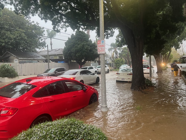
In downtown Santa Barbara, the flash point struck between 3 and 4 p.m. Sunday. The lower Eastside — down by Haley and Gutierrez streets were fit for kayaking and paddle-boarding but not for driving. The rains came so hard and fast that even in steep upland terrains — such as West Valerio Street just downslope from Elings Park — entire streets were covered and deep sheets threatened to stop cars in their tracks, particularly in the engineered dips in the road designed either to convey water or slow down speeding drivers.
On the lower reaches of De la Vina — below Haley Street — neighbors had formed their own de facto Bucket Brigade to get ready for the onslaught. One resident spent $3,000 in plywood and other materials to fend off the invading waters.
Last year’s rains deposited enough mud on the street to practically plant row crops; cars were swept away. This year, City Hall stepped up in advance, making city parking lots available as a safe parking refuge. As a result, only one car was reported seriously damaged.

City Councilmember Oscar Gutierrez emerged as the single most ubiquitous elected official, showing up in person with extra sand bags for residents. Earlier, Gutierrez extended the hours during which City Hall dispensed free sandbags to residents. Even so, Gutierrez recounted, there were lines around the block.
“There needs to be some kind of machine to fill those bags much more quickly,” he said. “People had to fill them manually; that’s why there were so many lines.”
In the half hour he left that stretch of De la Vina to go see how the Eastside was doing, Gutierrez said, the creek topped the Haley Street Bridge. It was the third time in three years and the third time since the new bridge had been installed as part of a creek-long, natural-bottomed, flood-control effort hatched after the 1995 floods scoured out the neighborhood and much of the city.
Even with the wider bridge, Haley Street remains a pinch point. That’s because the south-westerly abutment from the old bridge remains, making it a significant property protrusion. That remains a sticking point for onrushing waters and an element of the re-channelization project for Mission Creek that still needs to be done.
But that work is not restricted to just the abutment. Several key gaps in the work remain, starting where Canon Perdido Street crosses the creek and points down channel. To get the additional channel width necessary to carry the volume of water targeted by the improvements — 3,400 cubic feet per second — will require the purchase of considerable property that now functions as someone’s backyard.
That, however, is a fight for another day. For now, De la Vina Street resident and longtime neighborhood champion Sharon Byrne exclaimed, “We made it. It was pretty hairy. That creek was really raging.”
City Engineer Brian D’Amour added that further widening is still needed for the stretch from Canon Perdido to Gutierrez streets. While the improvements are not complete, he added, the work done so far greatly improved the carrying capacity of Mission Creek. Without those improvements, he noted, the creek could have only handled a maximum flow of 1,500 cubic feet per second, the equivalent of an eight-year storm event as opposed to the 20-year storm event to which the creek is currently calibrated. To put that in perspective, he said, last winter’s violent storms delivered the equivalent of a 100-year storm event. This weekend’s event, by contrast was the equivalent of a 10-year event.
For water managers, more concerned about long-term water supplies, this weekend’s rains were much more a help than a hindrance.
“Despite the pockets of localized flooding in town, this latest rain event was pretty ideal from a water supply perspective,” said city water czar Joshua Haggmark. “The rainfall came in steady over a long duration interval, which avoided major damage and sediment transport. The bulk of the rainfall was in the backcountry, where we get the biggest water supply benefit with rainfall exceeding eigh inches.”
That, Haggmark said, puts the City of Santa Barbara’s water supply on solid footing for the next three years. The city’s Ortega reservoir began spilling in December 2023 and Lake Cachuma — which supplies about half the water used by South Coast residents — is expected to spill sometime in the next few months. But for good measure, Haggmark added, “As you know, the next drought is always around the corner.”
Correction: An earlier version of this story reported that at the storm’s apex Sunday afternoon, rain gauges at El Capitan, Refugio, and Gaviota state parks registered rainfall of 3.6 inches in just one hour. However, those numbers appear to have been the result of malfunctioning sensors.
Related Posts


Premier Events

Sun, Jun 07
All day
Santa Barbara
SEIMANDI & LEPRIEUR – Hunt Slonem Exhibition Now – June 7

Fri, May 29
7:00 PM
Santa Barbara
Selah Dance Collective Presents Disco Elysium

Fri, May 29
10:00 PM
Santa Barbara
The Collective Band @ Seven Bar

Sat, May 30
12:00 PM
Los Olivos
90’s Unplugged at Firestone Winery

Sun, May 31
1:00 PM
Santa Barbara
Courtyard by Marriott Santa Barbara Presents Sunday Soundwaves

Sun, May 31
6:00 PM
Santa Barbara, CA
Blue Full Moon Ceremony

Sun, May 31
7:30 PM
Santa Barbara
Herman Matthews Presents: Phatback, Earl & Me! SOhO

Tue, Jun 02
5:00 PM
Santa Barbara
UCSB Media Arts & Technology End of Year Show (EoYS): “re:agency”

Tue, Jun 02
7:30 PM
Santa Barbra
Adelfos Ensemble presents: Enlightened Harmonies

Wed, Jun 03
11:40 AM
Santa Barbara
Women’s Prosperity Partners S.B. LEADS Club Virtual Meeting- Female Entrepreneurs

Wed, Jun 03
6:00 PM
Santa Barbara
Chaucer’s Book Talk – Greg Orfalea
Sun, Jun 07 All day
Santa Barbara
SEIMANDI & LEPRIEUR – Hunt Slonem Exhibition Now – June 7
Fri, May 29 7:00 PM
Santa Barbara
Selah Dance Collective Presents Disco Elysium
Fri, May 29 10:00 PM
Santa Barbara
The Collective Band @ Seven Bar
Sat, May 30 12:00 PM
Los Olivos
90’s Unplugged at Firestone Winery
Sun, May 31 1:00 PM
Santa Barbara
Courtyard by Marriott Santa Barbara Presents Sunday Soundwaves
Sun, May 31 6:00 PM
Santa Barbara, CA
Blue Full Moon Ceremony
Sun, May 31 7:30 PM
Santa Barbara
Herman Matthews Presents: Phatback, Earl & Me! SOhO
Tue, Jun 02 5:00 PM
Santa Barbara
UCSB Media Arts & Technology End of Year Show (EoYS): “re:agency”
Tue, Jun 02 7:30 PM
Santa Barbra
Adelfos Ensemble presents: Enlightened Harmonies
Wed, Jun 03 11:40 AM
Santa Barbara
Women’s Prosperity Partners S.B. LEADS Club Virtual Meeting- Female Entrepreneurs
Wed, Jun 03 6:00 PM
Santa Barbara

You must be logged in to post a comment.