On Sunday, the Rey Fire continued its eastward push, which began late Saturday night when a wind shift blew flames down toward the west side of Upper Oso Campground. At some point overnight, the fire burned across Oso Canyon, breaking through what firefighters had hoped would be the line that could contain the fire.
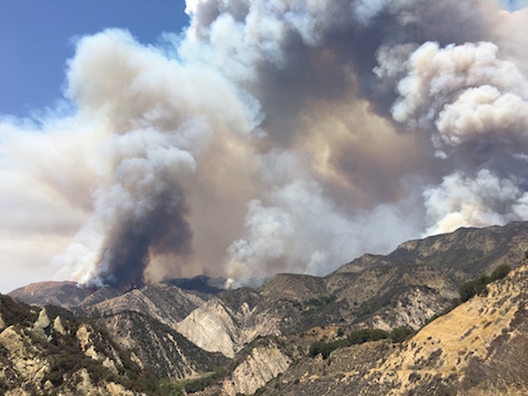
To make matters worse, at the point where the fire crossed Oso Canyon, two major landslides occurred, making it impossible for the engine crews to use the Buckhorn Jeepway to access the upper edge of the fire. By mid-morning on Sunday, two major columns of smoke began to rise several thousand feet in the air as years old brush began to ignite.
When the wind shifted slightly to the south, the massive columns could be seen from throughout the South Coast area, with reports coming from as far south as Thousand Oaks. Plumes towered over Santa Barbara for most of Sunday, in fact.
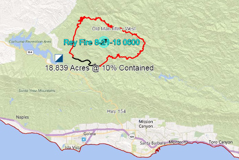
As of Sunday at 9 p.m., the Rey Fire had burned nearly 22,000 acres and was 20 percent contained. There are 1,260 personnel working on the blaze. Highway 154 remains open, but Paradise Road is still closed.
Big Plumes But Helpful Wind
By noon, the fire-driven columns had merged, creating a mile-long front that was moving slowly to the east. By 1 p.m., the front edge of the fire had moved along a high ridge towards Camuesa Peak, which looks directly down onto Gibraltar Reservoir. It appeared that, if the front were to continue east, it could reach the Santa Ynez River in the next several hours, posing a direct threat to the Santa Barbara area. Fortunately, just after 1 p.m., a 10 to 15 mph wind began blowing down river and to the interior, stalling the front and keeping the flames from dropping down into the river canyon.
For much of the day, this pattern played out, with the fire making slight gains to the east when the wind died down and then being pushed back when the winds picked up again. While the main front continued to stall out, fingers of fire began to appear on the steep hillsides on the north side of the Santa Ynez River. Flames could be seen in the upper reaches of many of the small side canyons leading directly down to the river.
Fortunately, the winds kept most of the fire line above the ridge and away from reaching the edge and dropping down into the canyon. However, in one larger side canyon just upstream from Live Oak Day Use Area, the flames came within several hundred yards of the river before helicopters and several retardant drops cooled things down.
For the next several hours, the canyon rim from Red Rock downstream to Upper Oso was the scene of airdrop after airdrop with the goal to cool down the edge of the fire until it had passed further to the east. Meanwhile, along the river, hand crews were busy cutting brush along the edge of the road and scraping out the dry grass to mineral soil so that firefighters would be able to burn out along the road should the fire begin to approach.
What’s Next?
While firefighters were able to prevent the Rey Fire from crossing the Santa Ynez River and posing an immediate threat to the South Coast on Sunday, the threat is far from over. As nightfall neared, the fire continued creeping eastward. Fire officials at Live Oak Command Center report that the fire crossed the Buckhorn Jeepway and is active in a number of canyons that lead directly down to Indian Canyon, Mono Creek, and the Dick Smith Wilderness. There are also reports the fire has already burned east of Camuesa Peak and is only five miles from Indian Creek.
The key objective on Monday will be to work from the east side of the fire to check it along Mono Creek, while other divisions focus on keeping the fire north of the Santa Ynez River. Given the drought conditions, dead or dying brush and scorching heat this will be a major challenge. It is possible the fire could reach the Santa Ynez River tomorrow.